When you picture a desert, the image that likely springs to mind is an endless expanse of golden sand dunes shimmering under a relentless sun. Yet this common perception barely scratches the surface of what these extraordinary environments actually offer. Deserts are geological laboratories, ecological treasure troves, and living museums that preserve both natural wonders and human history spanning millennia. From towering sandstone arches sculpted by wind over millions of years to ancient plant species that have adapted to survive with virtually no water, these arid landscapes challenge our assumptions about life, resilience, and beauty. The diversity found within desert ecosystems rivals that of any rainforest, whilst archaeological sites nestled in remote corners reveal sophisticated civilisations that flourished against impossible odds.
Geological formations and lithological diversity in arid ecosystems
Desert regions showcase some of the planet’s most spectacular geological phenomena, where the absence of vegetation allows the Earth’s geological history to be read like an open book. The lithological diversity—referring to the variety of rock types and formations—creates landscapes that seem almost sculptural in their complexity. Wind erosion, flash floods, extreme temperature fluctuations, and chemical weathering work together as patient artists, carving features that can take millions of years to achieve their current form. These processes create landforms that are both scientifically significant and visually stunning, attracting geologists and travellers alike.
Sandstone arches and natural bridges of wadi rum, jordan
Wadi Rum, often called the Valley of the Moon, presents a masterclass in how sandstone responds to desert weathering processes. The towering cliffs and natural arches here are composed primarily of Cambrian and Ordovician sandstone, estimated to be between 500 and 540 million years old. Natural arches form through a combination of joint enlargement, where parallel fractures in the rock gradually widen through freeze-thaw cycles and salt crystallisation, creating openings that eventually break through to form graceful spans. The Burdah Rock Bridge, standing approximately 35 metres high, is one of the highest natural arches in the world and demonstrates the remarkable structural integrity sandstone can maintain even when reduced to a slender ribbon of rock.
The iron oxide content within the sandstone gives Wadi Rum its characteristic red and orange hues, particularly dramatic during sunrise and sunset when the entire landscape appears to glow from within. These formations also preserve ancient Thamudic and Nabataean inscriptions, creating a palimpsest where human history and geological time intersect. The vertical rock faces reach heights exceeding 1,750 metres in some locations, making this desert a premier destination for rock climbing enthusiasts seeking routes through geological history.
Volcanic calderas and lava fields of the atacama desert, chile
The Atacama Desert’s geological character is shaped profoundly by its location along the Pacific Ring of Fire, where the Nazca Plate subducts beneath the South American Plate. This tectonic activity has created a landscape dominated by stratovolcanoes, some reaching altitudes exceeding 6,000 metres. The Licancabur volcano, standing at 5,916 metres, features a summit crater lake that remains partially frozen throughout the year, representing one of the highest bodies of water on Earth and harbouring extremophile microorganisms that offer insights into potential life on other planets.
Vast lava fields stretch across the desert floor, their black basaltic surfaces creating stark contrasts with the pale salt flats and rust-coloured mountains. These volcanic landscapes are relatively young in geological terms, with some flows dating back only a few thousand years. The Valle de la Luna, whilst not strictly volcanic, demonstrates how wind and water erosion can sculpt salt deposits, clay, and gypsum into alien-looking spires and valleys that genuinely resemble lunar terrain. The geological diversity here has made the Atacama a testing ground for Mars rover technology, as conditions closely simulate the Martian surface.
Hoodoo rock formations in goblin valley state park, utah
The hoodoos of Goblin Valley represent a particularly whimsical expression of desert erosion, where soft Entrada Sandstone has been carved into thousands of mushroom-
shaped pinnacles and squat, goblin-like figures. These hoodoos formed as harder caps of sandstone protected the softer layers beneath from erosion, leaving behind thousands of bizarre, anthropomorphic shapes clustered across a relatively small basin. Many stand only a few metres high, but their density and variety give the impression of wandering through a city built for giants. Differential weathering, driven by sporadic desert rainfall and intense temperature swings, causes some hoodoos to topple while new ones emerge, making Goblin Valley a dynamic landscape on human timescales. For visitors, the ability to walk freely among these formations, rather than observing them from a distance, creates an unusually immersive experience of desert geomorphology.
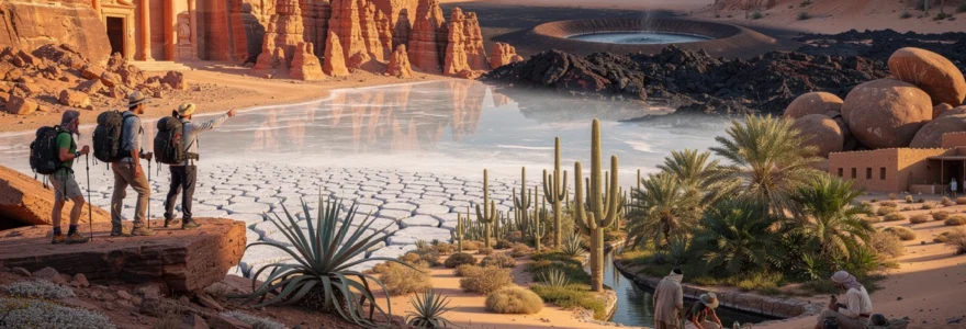
Salt pan crystallisation patterns at salar de uyuni, bolivia
Salar de Uyuni in southwestern Bolivia is the world’s largest salt flat, covering more than 10,000 square kilometres at an elevation of around 3,650 metres. What appears from afar as a uniform white expanse is, up close, a complex mosaic of polygonal salt crusts formed by repeated cycles of evaporation and mineral precipitation. As brine beneath the surface slowly dries, salt crystals grow and push against each other, fracturing into roughly hexagonal plates that resemble dried, cracked paint on a colossal scale. These geometric patterns are not random; they reflect the balance between upward capillary flow of brine and downward gravitational settling, a process scientists study to better understand similar features on Mars and ancient lake beds.
During the rainy season, a thin layer of water transforms Salar de Uyuni into a vast natural mirror, blurring the boundary between earth and sky. This reflective surface has turned the salt pan into a magnet for photographers and travellers searching for surreal desert landscapes that offer more than just sand and heat. The high albedo of the salt, combined with the flatness of the terrain—deviations are often less than a metre across tens of kilometres—has also led to its use in satellite calibration and even discussions about renewable energy projects. When you stand in the centre of the salar, surrounded by endless white and a 360-degree horizon, it becomes clear why this desert environment is often described as otherworldly.
Granite inselbergs and bornhardts of the namib desert
In the Namib Desert, some of the most striking landforms are not dunes but isolated granite mountains known as inselbergs and domed rock masses called bornhardts. These features, including famous sites such as Spitzkoppe and the Brandberg Massif, are remnants of ancient bedrock that resisted erosion while the surrounding material was stripped away over tens of millions of years. The result is a landscape where monolithic rock islands rise abruptly from the plain, their sheer faces glowing pink and orange in the low desert light. Weathering along joints and fractures has sculpted tafoni (honeycomb-like cavities), overhangs, and boulder fields that create a natural playground for climbers and a field laboratory for geomorphologists.
Because they capture scarce moisture and provide shade, granite inselbergs serve as biodiversity hotspots within an otherwise harsh desert. Shallow depressions collect rainwater, while cracks and ledges offer shelter for lichen, succulents, reptiles, and small mammals that would struggle to survive on the open gravel plains. From a distance, bornhardts can appear smooth and featureless, but as you approach, their surfaces reveal a tapestry of mineral veins, weathering rinds, and desert varnish—a thin coating of manganese and iron oxides that can take thousands of years to develop. Exploring these rocky islands is a reminder that desert landscapes are as much about stone and time as they are about sand and heat.
Endemic flora adaptations and xerophytic plant communities
Desert plant communities have evolved some of the most ingenious survival strategies in the natural world. Rather than being empty, these arid ecosystems support xerophytes—plants adapted to conserve water, tolerate extreme heat, and make the most of brief rainfall events. From deep taproots that mine groundwater to leaves reduced to spines that minimise transpiration, every structural detail tells a story of evolutionary problem-solving. When we focus only on dunes, we risk overlooking these living archives of adaptation, many of which are endemic and found nowhere else on Earth.
For travellers interested in desert biodiversity, understanding how plants survive in such hostile conditions adds a new layer of appreciation to the landscape. It transforms a seemingly uniform scrubland into a mosaic of microhabitats, each home to species with its own specialised niche. Many of these xerophytic plant communities are also key to stabilising soils, supporting pollinators, and providing resources for local communities that have lived in desert environments for thousands of years. As climate change intensifies droughts in many regions, researchers increasingly look to desert flora for clues about drought-resistant agriculture and sustainable land management.
Resurrection plants and cryptobiotic soil crusts in the negev
In Israel’s Negev Desert, so-called resurrection plants such as Sélaginelle lepidophylla and certain species of Anastatica can survive almost complete desiccation, reviving when exposed to moisture. Their tissues curl tightly as they dry, reducing surface area and protecting vital cells from UV radiation and oxidative damage. When rare rain arrives, they rehydrate within hours, unfurling and resuming photosynthesis—a biological feat akin to pressing “pause” on life itself. For scientists, these plants offer valuable models for understanding drought tolerance at the molecular level.
Equally remarkable are the cryptobiotic soil crusts that blanket many Negev slopes and plateaus. Composed of cyanobacteria, lichens, mosses, and fungi, these fragile communities bind soil particles together, reducing erosion and enhancing water infiltration. They also fix atmospheric nitrogen, improving fertility in an environment where nutrients are scarce. To the untrained eye, they may look like nothing more than dark, knobbly patches of dirt, but crushing them underfoot can destroy decades of slow growth. When you hike in the Negev—or any desert that hosts these crusts—sticking to established trails is a simple yet crucial way to protect these hidden ecosystems.
Ancient welwitschia mirabilis populations of namibia’s skeleton coast
Along Namibia’s Skeleton Coast and inland gravel plains, the bizarre Welwitschia mirabilis stands out as one of the world’s most unusual desert plants. Often described as a “living fossil,” this gymnosperm may live for more than 1,500 years, with some individuals estimated to be older than many human civilisations. Each plant produces only two leaves during its lifetime; these strap-like leaves grow continuously from the base but become shredded and tattered at the tips by wind and sand, giving Welwitschia its characteristic dishevelled appearance. Despite the harsh climate, it survives on minimal rainfall, drawing moisture from fog and deep taproots that tap subsurface water.
Welwitschia’s distribution is tightly linked to the cool, foggy currents of the Atlantic Ocean, making its populations both unique and vulnerable. Recent studies have highlighted concerns about climate change shifting fog patterns, potentially impacting this already restricted species. When you encounter a Welwitschia in the wild, you are essentially looking at a plant that has been performing the same quiet survival routine since before the rise of flowering plants. For visitors, guided tours in conservation areas such as the Namib-Naukluft National Park provide a responsible way to see these ancient organisms without damaging their fragile habitat.
Saguaro cactus forests and nurse plant relationships in sonoran wilderness
In the Sonoran Desert of Arizona and northern Mexico, towering saguaro cacti form some of the most iconic desert landscapes on Earth. These columnar giants can grow over 12 metres tall and live for 150 to 200 years, but their early life stages depend heavily on so-called nurse plants. Young saguaros often germinate in the shade of shrubs or trees such as palo verde and mesquite, which provide shelter from intense sun and temperature extremes, much like an umbrella shields a person on a scorching day. Without this protective canopy, many seedlings would not survive their first few summers.
This nurse plant relationship demonstrates how cooperation, rather than competition, can dominate in resource-scarce environments. As saguaros mature, they eventually overtop or outlive their nurses, providing new habitat for birds, bats, and insects that rely on their flowers, fruits, and internal cavities. For hikers exploring protected areas like Saguaro National Park, recognising these plant partnerships turns a simple cactus forest into a complex web of interactions. Staying on marked trails and avoiding damage to woody shrubs is a small but meaningful way to support the regeneration of these emblematic desert giants.
Date palm oases and underground qanat irrigation systems
Across North Africa, the Middle East, and parts of Central Asia, date palm oases demonstrate how humans have worked with desert flora to create sustainable agricultural systems. The classic “three-layer” oasis structure—tall date palms, mid-level fruit trees, and low-lying crops—maximises shade and reduces evaporation, effectively engineering a cooler microclimate in the midst of arid surroundings. At the heart of many traditional oases lies the qanat system: gently sloping underground channels that transport groundwater over long distances using gravity alone. This ancient technology, some examples of which are more than 2,500 years old, delivers water with minimal loss to evaporation, a critical advantage in hot, dry climates.
Walking through a functioning oasis, you can feel the temperature drop and the air grow more humid, a tangible reminder that desert ecosystems are not fixed but can be carefully nurtured. However, modern pressures such as over-pumping aquifers, salinisation, and urban expansion threaten many historic oases and their agro-ecosystems. Supporting responsible tourism initiatives, purchasing local date products, and learning about traditional water management practices are practical ways to help keep these cultural and ecological refuges alive. In many regions, the knowledge embedded in qanat systems is now being revisited as communities search for low-energy solutions to water scarcity.
Archaeological heritage sites and prehistoric human settlement evidence
Desert landscapes are not only geological and ecological wonders; they also preserve an exceptional archaeological record. Low humidity, sparse vegetation, and slow rates of soil formation mean that artefacts, rock art, and even entire cities can remain remarkably intact for millennia. From monumental stone facades carved into cliffs to delicate geoglyphs etched onto desert pavements, these sites reveal how past societies adapted to and thrived in arid environments. As you explore them, it becomes clear that deserts have long been crossroads of trade, innovation, and cultural exchange.
Because of their remoteness, many desert heritage sites escaped large-scale disturbance until relatively recently, allowing archaeologists to study ancient routes, water management systems, and settlement patterns in situ. Yet this same remoteness presents challenges for conservation, as limited oversight can leave them vulnerable to vandalism, unregulated tourism, and looting. When visiting desert ruins or rock art galleries, following local guidelines and refraining from touching or climbing on structures is more than a matter of etiquette—it is a direct contribution to safeguarding irreplaceable records of human history.
Nabataean rock-cut architecture at petra’s treasury and monastery
Perhaps the most famous example of desert archaeology is Petra in southern Jordan, the former capital of the Nabataean Kingdom. Hidden within a maze of sandstone canyons, Petra’s rock-cut architecture blends engineering prowess with artistic sophistication. The iconic Treasury (Al-Khazneh) and the Monastery (Ad-Deir) are carved directly into towering cliffs, their façades adorned with Hellenistic and Near Eastern motifs that testify to Petra’s role as a trading hub connecting Arabia, the Levant, and the Mediterranean. Approaching the Treasury through the narrow Siq gorge, with its high walls and slivers of sky above, feels like stepping through a geological time tunnel into a lost city.
Beyond the photogenic monuments, Petra’s true ingenuity lies in its water management systems. The Nabataeans constructed channels, cisterns, and dam structures to capture flash floods and store water for dry periods, effectively turning a desert valley into a flourishing urban centre. Archaeological surveys have revealed terraced agriculture and gardens that would have softened the starkness of the surrounding desert, much like modern oases do today. For visitors, exploring the less crowded trails that lead to viewpoints above the Monastery or to the High Place of Sacrifice offers a broader perspective on how intimately Petra is integrated into its rocky environment.
Pre-columbian nazca lines geoglyphs in southern peru
On the coastal desert plains of southern Peru, the Nazca Lines form one of the world’s most enigmatic cultural landscapes. These geoglyphs, created between roughly 500 BCE and 500 CE, consist of hundreds of straight lines, geometric shapes, and animal figures etched into the dark desert surface by removing the oxidised pebbles to reveal lighter soil beneath. Stretching for kilometres across an arid plateau, some figures—such as the hummingbird, monkey, and spider—are over 100 metres long and best appreciated from the air. The desert’s extreme dryness and lack of vegetation have helped preserve these designs for centuries, making them a remarkable example of how climate can act as a protective archive.
Researchers have proposed numerous interpretations of the Nazca Lines, from astronomical calendars to ritual paths associated with water and fertility. Whatever their precise meaning, they clearly reflect a sophisticated understanding of landscape, scale, and coordination among the people who created them. When you fly over the Nazca Desert or visit designated viewing platforms, it is important to remember that even a single careless footprint can damage these delicate features. Modern management efforts now restrict access to protect the geoglyphs, demonstrating a growing recognition that desert heritage is both priceless and fragile.
Ancient silk road caravanserais along the taklamakan desert
Bordering the vast Taklamakan Desert in China’s Xinjiang region, the ruins of ancient caravanserais and trading towns mark the arteries of the historic Silk Road. These fortified inns and settlements offered shelter, water, and trade opportunities to merchants and pilgrims crossing some of the harshest terrain on the planet. Positioned strategically along oases and river valleys, they formed a lifeline of connectivity between East Asia, Central Asia, and the Mediterranean world. Archaeological excavations have uncovered textiles, manuscripts, and everyday objects that reveal the cosmopolitan nature of these desert waystations.
Many of these sites, such as the ancient city of Niya or the ruins near the Khotan and Kuqa oases, are slowly being reclaimed by shifting sands and changing water courses. In this sense, the desert behaves like a vast archive with pages that can be both revealed and erased by wind and time. As modern infrastructure projects expand across Central Asia, balancing development with the preservation of Silk Road heritage has become a pressing concern. For travellers, choosing guided tours that work with local communities and respect access regulations is one way to ensure that these traces of overland trade survive for future generations.
Aboriginal rock art galleries in australia’s kimberley region
In the remote Kimberley region of northwestern Australia, sandstone escarpments and rock shelters host some of the most extensive and ancient rock art galleries in the world. Many of these paintings, including the striking Gwion Gwion and Wandjina figures, are found in semi-arid and desert margins where seasonal rivers carve through plateau country. The images depict ancestral beings, animals, and ceremonial scenes, forming an ongoing cultural record that, according to Indigenous traditions, stretches back tens of thousands of years. Dry conditions and sheltered locations have helped preserve pigments that would quickly degrade in wetter climates.
These rock art sites are not simply remnants of the past; they remain deeply embedded in the living cultural practices and law of Aboriginal communities. Access is often controlled by Traditional Owners, and visiting with an authorised guide provides not only context but also ensures that sacred places are respected. For those exploring desert landscapes in Australia, recognising that the land is a cultural as well as ecological entity can profoundly change how we understand “empty” spaces. In many cases, what appears to be uninhabited desert is, in fact, a densely storied landscape of songlines, creation stories, and ongoing custodianship.
Megafauna biodiversity and desert-adapted wildlife populations
Despite their reputation as lifeless wastelands, deserts support a surprising array of megafauna and smaller species exquisitely adapted to extreme conditions. Large mammals such as dromedary camels, Arabian oryx, addax antelope, and desert elephants have evolved physiological and behavioural strategies that allow them to cope with heat, dehydration, and sparse vegetation. Many are crepuscular or nocturnal, emerging at dawn or dusk to forage when temperatures are more tolerable. If you time your desert excursions carefully, you can witness these brief windows of intense activity that contrast with the midday stillness.
Smaller animals—including fennec foxes, jerboas, sidewinder rattlesnakes, and sandgrouse—often rely on specialised locomotion, burrowing behaviour, or feather and fur adaptations to navigate hot, shifting substrates. Some insects and reptiles even exploit temperature gradients across the sand surface, moving between sun and shade with the precision of a tightrope walker. These complex survival strategies have made deserts important natural laboratories for studying thermoregulation and water balance in animals. However, many desert species are now under pressure from habitat fragmentation, illegal hunting, and climate-induced shifts in vegetation patterns.
When planning wildlife-focused travel in desert regions, it’s crucial to choose operators that follow ethical wildlife viewing guidelines, maintain appropriate distances, and avoid disturbing den sites or waterholes. Simple choices—like using red-filtered lights at night, keeping noise to a minimum, and sticking to existing tracks—can reduce stress on sensitive species. As arid zones expand in some parts of the world, lessons learned from desert-adapted wildlife may also inform how other fauna cope with increasing heat and drought. In this way, deserts once again prove that they offer far more than just sand and heat; they offer insights into resilience that will matter across the planet.
Astronomical observation conditions and dark sky preserve status
One of the most overlooked advantages of desert landscapes is their exceptional quality for astronomical observation. Low humidity, minimal cloud cover, high elevation, and distance from urban light pollution combine to create some of the clearest night skies on Earth. In many hyper-arid regions, more than 300 nights per year are suitable for stargazing, a statistic that professional observatories and amateur astronomers alike take seriously. Standing under a truly dark desert sky, where the Milky Way casts a faint shadow on the ground, can be as transformative as any sunrise over dunes.
Recognising the scientific and cultural value of these pristine skies, a growing number of desert regions have sought dark sky preserve or dark sky reserve status from organisations such as the International Dark-Sky Association. These designations encourage communities to adopt responsible lighting practices—shielded fixtures, warm colour temperatures, and limited overnight illumination—that protect nocturnal wildlife as well as observation conditions. For travellers, destinations that prioritise dark skies often offer guided night walks, astrophotography workshops, and observatory tours that turn a desert visit into a cosmic experience.
ALMA observatory operations in chile’s high-altitude chajnantor plateau
On Chile’s Chajnantor Plateau in the Atacama Desert, the Atacama Large Millimeter/submillimeter Array (ALMA) operates at an elevation of about 5,000 metres. This extreme altitude, combined with the Atacama’s exceptionally low atmospheric moisture, makes the site ideal for observing cold gas and dust in distant galaxies and star-forming regions. ALMA’s 66 high-precision antennas can be rearranged across baselines up to 16 kilometres, functioning like a single giant telescope that reveals details comparable to resolving a golf ball from 15 kilometres away. The dry desert air is crucial here; water vapour in the atmosphere would otherwise absorb the millimetre and submillimetre wavelengths ALMA is designed to detect.
Because of the harsh conditions at Chajnantor, most of ALMA’s operations are controlled from a lower-altitude facility in the nearby town of San Pedro de Atacama. Visitors cannot tour the array site itself without special permission, but public outreach centres and guided tours explain how this desert observatory contributes to breakthroughs in cosmology and planetary science. If you are interested in combining desert travel with science, planning a stay in San Pedro provides opportunities to visit ALMA’s Operations Support Facility and participate in local stargazing excursions. It is a vivid reminder that some of our most advanced technologies depend on the raw, elemental qualities of desert environments.
Astrotourism infrastructure at NamibRand nature reserve
In Namibia, the privately managed NamibRand Nature Reserve has become a flagship destination for astrotourism in desert settings. Recognised as one of Africa’s first International Dark Sky Reserves, NamibRand has implemented strict lighting controls, ensuring that artificial light does not spill into the nightscape. Lodges and camps within the reserve often feature open-air viewing decks, roll-out star beds, and fixed telescopes, inviting guests to spend extended time under the stars. Because humidity is low and horizons are unobstructed, constellations, the Magellanic Clouds, and the Milky Way’s dusty lanes appear with remarkable clarity.
Astrotourism here is deliberately paired with conservation and education. Guides trained in both ecology and astronomy help visitors connect celestial cycles with desert rhythms on the ground—phases of the moon, for instance, influence nocturnal animal behaviour and navigation. When you choose a destination like NamibRand, you are not only gaining access to exceptional skies but also supporting a conservation model that values darkness as a natural resource. The experience can be akin to attending a planetarium show where the roof has been removed and replaced by the real universe.
Bortle scale measurements in morocco’s sahara erg chebbi
Morocco’s Erg Chebbi, a dramatic dune field near Merzouga on the edge of the Sahara, has become increasingly popular with travellers seeking both classic camel treks and pristine night skies. Away from village lights, Bortle Scale measurements—a standard for classifying sky darkness—often fall in the Class 2 to Class 3 range, indicating skies where the Milky Way is highly structured and zodiacal light is clearly visible. For comparison, most suburban areas in Europe or North America sit around Class 5 or 6, where only the brightest stars pierce the glow of light pollution. In Erg Chebbi, the night can feel almost three-dimensional, with layers of stars extending to the horizon above sweeping silhouettes of sand.
Many desert camps now incorporate basic astronomical equipment and orientation sessions into their offerings, helping guests distinguish constellations and understand seasonal changes in the sky. If you are planning a visit, choosing a camp that limits generator use, shields its lights, and promotes quiet hours after dark will significantly enhance your stargazing experience. Bringing binoculars and a red-light headlamp can turn even a short stay into a mini astronomical retreat. In an era when true darkness has become rare, these pockets of the Sahara highlight just how much our perception of the night has been altered by urbanisation.
Adventure tourism activities and extreme landscape navigation techniques
Beyond their scientific and cultural riches, desert regions have emerged as prime arenas for adventure tourism. From multi-day camel caravans and 4×4 expeditions to long-distance trail running and technical rock climbing, these landscapes attract travellers seeking both challenge and solitude. The combination of wide-open spaces, minimal infrastructure, and rapidly changing conditions means that safe exploration requires respect for local knowledge and a solid understanding of navigation. In many ways, learning to move responsibly through a desert is like learning a new language: once you grasp its grammar, the landscape becomes far more legible.
Reliable navigation in deserts often depends on a blend of traditional techniques and modern technology. Bedouin guides, Aboriginal trackers, and Tuareg nomads have long read subtle cues—wind ripples on dunes, the orientation of rock outcrops, and the distribution of plants—to chart safe routes and locate water. Today, GPS devices and satellite maps add another layer of security, but they are not infallible; batteries fail, signals drop, and digital maps rarely capture micro-scale hazards such as soft sand pits or flash flood channels. For anyone considering self-guided desert travel, carrying a paper map and compass, knowing how to use them, and being conservative with daily distance goals is non-negotiable.
Environmental conditions in deserts can change dramatically within hours, with temperatures swinging by more than 20°C between day and night and sudden sandstorms reducing visibility to a few metres. Hydration planning, sun protection, and layering for cold nights are critical, as is an honest assessment of your fitness and experience. Many experienced desert travellers follow a simple rule: move early and late, rest in the midday heat, and always carry more water than you think you need. Joining guided trips for technical activities—such as canyon descents in Wadi Rum, dune crossings in the Empty Quarter, or long traverses of Australia’s Simpson Desert—allows you to focus on the experience while benefiting from expert route-finding and risk management.
Ultimately, what makes desert adventure tourism so compelling is the way it strips travel down to essentials: navigation, water, shelter, and an acute awareness of the horizon. When you hike along the crest of a dune, scramble up a granite inselberg, or camp beneath a sky crowded with stars, you engage directly with landscapes shaped by deep time and extreme forces. These are environments that demand humility but reward curiosity, offering far more than just sand and heat to those who take the time to understand them.


