Floating silently through the morning sky in a wicker basket, suspended beneath a vibrant canopy of fabric, represents one of humanity’s most enchanting ways to experience the world from above. Hot air ballooning combines the ancient dream of flight with modern engineering precision, offering passengers an unparalleled perspective on Earth’s most spectacular landscapes. This aerial adventure transforms familiar terrain into intricate tapestries of colour and texture, revealing patterns and details invisible from ground level.
The sensation of drifting with wind currents, rising and descending through atmospheric layers, creates a unique connection between passenger and environment that no other form of aviation can replicate. Unlike the mechanical roar of aircraft engines, the gentle whisper of heated air and occasional propane burner ignition maintains the natural soundscape below, allowing wildlife observation and landscape appreciation in their purest forms.
Hot air balloon flight physics and atmospheric navigation principles
Understanding the fundamental physics behind hot air balloon flight reveals the elegant simplicity of this centuries-old technology. The principle of buoyancy, first articulated by Archimedes, governs every aspect of balloon operation. When air inside the envelope reaches temperatures significantly higher than the surrounding atmosphere, the density differential creates lift force sufficient to raise the entire balloon system, including basket, passengers, and equipment.
Buoyancy calculations and envelope heat distribution systems
Professional balloon operators rely on precise buoyancy calculations to determine optimal load capacity and flight duration. The mathematical relationship between envelope volume, air temperature differential, and total system weight determines ascent rates and maximum achievable altitudes. Modern balloon envelopes typically contain between 77,000 and 106,000 cubic feet of heated air, generating lift forces ranging from 1,000 to 3,000 pounds depending on atmospheric conditions.
Heat distribution within the envelope follows predictable thermodynamic patterns, with hottest air accumulating at the crown and gradually cooling towards the mouth opening. This temperature gradient creates internal convection currents that pilots must understand to maintain stable flight characteristics. Advanced envelope designs incorporate strategically positioned panels and venting systems to optimise heat retention and control descent rates during landing sequences.
Wind pattern analysis and Altitude-Dependent current utilisation
Successful balloon navigation depends entirely on understanding wind patterns at different atmospheric layers. Pilots study meteorological data to identify wind direction and velocity variations between surface level and potential flight altitudes, often finding dramatically different conditions separated by mere hundreds of feet. This three-dimensional wind analysis allows experienced pilots to plot approximate flight paths by ascending or descending into favourable current systems.
Atmospheric stability significantly affects balloon controllability, with thermal activity creating updrafts and downdrafts that can dramatically alter flight dynamics. Morning flights typically offer the most stable conditions, as overnight cooling creates minimal thermal activity and consistent wind patterns. However, skilled pilots can utilise thermal columns during afternoon flights to achieve extended flight durations and explore varied altitude ranges.
Basket load management and centre of gravity optimisation techniques
Proper weight distribution within the passenger basket directly impacts flight safety and comfort levels. Professional operators calculate precise centre of gravity positions based on passenger weights, equipment placement, and fuel distribution to maintain optimal balloon stability throughout the flight duration. Uneven weight distribution can cause basket tilting, creating uncomfortable conditions and potentially dangerous landing scenarios.
Load management extends beyond simple weight calculations to include dynamic weight shifts during flight operations. Passengers moving within the basket, fuel consumption reducing total system weight, and equipment repositioning all affect balance characteristics. Experienced pilots continuously monitor these changes and adjust burner operation accordingly to maintain smooth flight profiles.
Propane burner systems and thermal efficiency control methods
Modern propane burner systems represent sophisticated engineering achievements, delivering precise heat output control through electronically managed fuel injection systems. These thermal efficiency mechanisms allow pilots to make minute adjustments to envelope temperature, controlling ascent and descent rates with remarkable precision. Twin-burner configurations provide redundancy and enhanced heat distribution capabilities for larger balloon systems.
Fuel consumption calculations become critical during extended flights, with typical consumption rates ranging from 15 to 25 gallons per hour depending on atmospheric conditions and flight manoeuvres.
To maximise endurance and safety, pilots often operate below maximum burner power, using short, controlled bursts to maintain a stable envelope temperature. Flame length, nozzle configuration, and fuel pressure are all tuned so that as much heat as possible enters the envelope rather than dissipating into the surrounding air. Regular maintenance of hoses, valves, and regulators ensures consistent performance, while pre-flight fuel checks and contingency reserves provide vital redundancy in case of unexpected wind shifts or prolonged flight durations.
Premier global hot air ballooning destinations and landscape photography opportunities
From desert canyons to vineyard valleys, certain regions of the world are almost synonymous with hot air balloon rides. These premier destinations combine reliable flying conditions with striking visual contrasts that are ideal for aerial photography. While every balloon flight offers a unique view, planning a journey around these iconic locations allows you to capture landscapes from above that are instantly recognisable and profoundly memorable.
Each global hotspot for balloon rides has its own optimal season, typical flight profile, and signature photographic opportunities. By aligning your travel dates with local weather patterns and light conditions, you can dramatically improve your chances of both flying and returning with exceptional images. The following destinations illustrate how geography, culture, and climate converge to create some of the most spectacular hot air ballooning experiences on the planet.
Cappadocia turkey rock formation flights and dawn light capture
Cappadocia’s volcanic valleys and fairy chimneys have become the reference point for hot air ballooning holidays worldwide. Pre-dawn launches allow balloons to rise just as the first light spills across Göreme National Park, painting rock formations in soft pinks and golds. From above, eroded pillars, cave dwellings, and ancient churches form abstract patterns that are ideal for wide-angle landscape photography.
For photographers seeking to capture hundreds of balloons in a single frame, positioning your camera toward the densest part of the launch zone at blue hour yields particularly cinematic results. As sunrise progresses, you can shift your focus to side-lit ridges and shadow-filled canyons that reveal Cappadocia’s geological layering. Because flights here operate most frequently between April and October, it is wise to build in at least two or three extra mornings to mitigate weather-related cancellations and maximise your chances of ideal shooting conditions.
Serengeti tanzania wildlife migration aerial surveillance routes
In the Serengeti, hot air balloon rides function almost like silent wildlife surveillance missions, offering a non-intrusive vantage point over one of Earth’s greatest animal migrations. As you drift above the savannah at dawn, herds of wildebeest, zebra, and gazelle appear as shifting patterns on a vast yellow-green canvas. From altitude, predator–prey interactions, river crossings, and dust trails become visible in ways ground-based safaris can never match.
Most balloon safaris in Tanzania follow routes aligned with the seasonal movement of the Great Migration, typically between central and northern Serengeti from June to October. Photographers should favour fast telephoto lenses to isolate small groups of animals within the broader landscape, and be ready for rapidly changing compositions as the basket follows meandering wind currents. Because you cannot control the precise flight path, a flexible mindset—treating each ride as an unpredictable documentary assignment—will help you make the most of whatever scenes unfold beneath you.
Napa valley california vineyard canopy surveys and seasonal colour documentation
Napa Valley offers a very different kind of aerial spectacle: manicured vineyards, orderly rows of vines, and reflective reservoirs framed by gentle hills. Hot air balloon rides here often launch just after sunrise, when cool morning air settles over the valley and low ground fog can create ethereal layers. From the basket, geometric vineyard patterns resemble an agricultural quilt, ideal for capturing leading lines and repeating textures.
For those interested in documenting seasonal colour from above, autumn is the most visually rewarding time to fly. In October and early November, vine leaves turn shades of amber, crimson, and rust, while harvest activities add movement and human interest to otherwise peaceful scenes. Photographers can treat balloon flights in Napa like aerial vineyard canopy surveys, recording differences in soil, planting density, and drainage that become obvious only from altitude. Pairing a hot air balloon ride with visits to wineries later in the day creates a holistic understanding of how landscape, climate, and cultivation intersect.
Bagan myanmar ancient temple complex aerial archaeological perspectives
Bagan, with its thousands of temples and stupas scattered across a floodplain of the Irrawaddy River, delivers some of the world’s most compelling aerial archaeological views. Hot air balloons ascend into the soft morning haze as the first light catches gilded spires and brick pagodas emerging from the mist. From above, you can appreciate the alignment of religious structures along ancient processional routes and waterways, gaining a spatial understanding that ground tours rarely provide.
Balloon flights over Bagan usually maintain relatively low altitudes, often just a few hundred feet above the tree canopy, allowing passengers to clearly see weathered carvings, crumbling walls, and restoration work in progress. For photography, this close proximity encourages the use of mid-range zoom lenses rather than extreme telephotos, balancing architectural detail with enough context to show temples in their forested setting. Given the region’s sensitivity and evolving regulations, it is important to choose licensed operators who coordinate closely with heritage authorities to minimise disturbance and protect this unique cultural landscape.
Loire valley france château estate boundary mapping from altitude
The Loire Valley’s mosaic of châteaux, vineyards, and river meanders becomes especially legible when seen from a hot air balloon. Morning and late afternoon flights reveal how estate boundaries follow natural features: tree-lined avenues, hedgerows, and oxbow lakes form elegant curves that seemed abstract on the ground but read like a living map from above. Balloon rides often drift along the Loire River itself, giving you continuously changing perspectives on fortresses, Renaissance palaces, and manicured gardens.
For photographers, the Loire offers a chance to capture almost architectural diagrams in real time. You can trace geometric garden layouts, moat systems, and agricultural parcels that reflect centuries of landscape design. Using an ultra-wide lens, it is possible to frame both château and surrounding countryside in a single composition, emphasising how these historic buildings command their environment. Flying from April to October provides the best combination of stable weather, lush foliage, and extended golden hours for château estate photography from altitude.
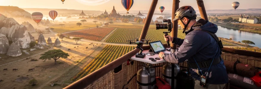
Professional aerial photography equipment and stabilisation technologies
Translating the emotional impact of hot air balloon rides into compelling images requires more than simply pointing a camera over the edge of the basket. While the ride feels smooth, subtle movements, burner vibrations, and changing light can all challenge image sharpness and exposure. By understanding which equipment functions best in a balloon environment, you can dramatically increase the success rate of your aerial photographs and come home with a portfolio that truly reflects the experience.
Unlike in helicopters or fixed-wing aircraft, you have limited space and no option to open windows or doors. This constraint favours compact yet capable camera systems, efficient stabilisation technologies, and a carefully curated selection of lenses. With thoughtful planning, you can travel light while still covering everything from sweeping landscapes to intimate wildlife scenes during your hot air balloon ride.
Gimbal-mounted camera systems for vibration compensation
Although hot air balloons are relatively gentle platforms, micro-movements from wind shifts and passenger motion can still introduce blur, especially at longer focal lengths. Gimbal-mounted camera systems, originally developed for drones and cinema rigs, provide highly effective vibration compensation in this context. By isolating the camera from your hand movements and minor basket oscillations, a gimbal allows you to shoot at slower shutter speeds without sacrificing sharpness.
Many photographers now pair mirrorless cameras or smartphones with compact three-axis gimbals specifically designed for travel. The gimbal’s motors continually adjust the camera’s orientation to keep the horizon level, which is particularly valuable when the balloon rotates slowly or tilts slightly during burner bursts. Think of the gimbal as an invisible tripod in the sky: it adds a small amount of weight to your kit but dramatically expands your creative options in challenging light.
Ultra-wide angle lens selection for landscape capture
When you are suspended hundreds or thousands of feet above the ground, ultra-wide angle lenses become essential tools for conveying scale and depth. Focal lengths between 12mm and 24mm (full-frame equivalent) allow you to include the curve of a valley, the sinuous path of a river, and even parts of the balloon envelope in a single frame. This perspective communicates the immersive nature of hot air balloon rides more effectively than tight crops alone.
However, not all wide lenses behave the same way from altitude. Prime lenses often offer superior sharpness and lower distortion, but modern zooms provide valuable flexibility as scenes change rapidly below. To avoid exaggerated stretching at the edges, you can keep key subjects away from the frame borders and slightly tilt the camera downward. Treat your ultra-wide lens like a storytelling device: use it when you want to place the viewer inside the basket with you, surrounded by sky and landscape.
Drone integration protocols for multi-perspective documentation
In some regions, professional crews combine hot air ballooning with drone operations to capture multi-perspective documentation of the same landscape. When permitted by local aviation authorities, drones can fly around or below balloons, recording dynamic external views that complement your in-basket photography. This approach requires strict protocols to ensure safety and regulatory compliance; in many jurisdictions, only licensed operators working under specific permissions may deploy drones near manned aircraft.
If you are considering integrating drone footage into your aerial project, always consult both the balloon company and relevant aviation regulations in advance. In most cases, drones must be launched and recovered from the ground, with flight paths planned to avoid any potential intersection with balloon routes. Think of drones as external observers and hot air balloons as human vantage points; together, they can provide a comprehensive visual record of landscapes from multiple altitudes and angles, but only when operated with meticulous planning and coordination.
High-altitude light metering and exposure bracketing techniques
Light behaves differently at altitude, especially during sunrise and sunset flights when contrast between sky and ground can be extreme. Automatic metering systems often struggle in these conditions, either overexposing bright clouds or underexposing shadowed terrain. To compensate, many aerial photographers rely on exposure bracketing: capturing a sequence of frames at different exposure settings that can later be blended for a balanced result.
A practical approach is to set aperture and ISO manually, then adjust shutter speed across a two- or three-stop range using your camera’s bracketing function. Evaluating the brightest portion of the sky with your light meter and deliberately underexposing by one stop can also help retain colour and detail in clouds. By treating the sky–ground relationship like a high-contrast studio scene, you maintain creative control rather than leaving critical decisions to automatic algorithms that were not designed for such complex lighting.
Commercial ballooning operations and passenger safety protocols
Behind every peaceful hot air balloon ride lies a meticulous web of safety checks, operational planning, and regulatory oversight. Commercial ballooning is governed by aviation authorities in much the same way as other forms of flight, with licensed pilots, certified equipment, and documented maintenance schedules. Understanding these safety protocols can help you feel more confident as a passenger and appreciate the professionalism involved in even the most relaxed sunrise flight.
Before passengers arrive at the launch site, crews conduct pre-flight inspections of the envelope, basket, burner assembly, and fuel system. Pilots verify weather briefings, confirm weight and balance calculations, and determine whether conditions meet safety thresholds. During the mandatory safety briefing, you will learn boarding procedures, in-flight conduct guidelines, and landing positions, ensuring that everyone in the basket responds consistently to pilot instructions throughout the flight.
Meteorological planning and flight risk assessment procedures
Because hot air balloons move entirely with the wind, meteorological planning is central to every commercial operation. Pilots routinely analyse surface observations, upper-air wind forecasts, and high-resolution weather models to predict how air masses will behave during the flight window. They look not just at wind speed and direction at ground level, but also at multiple altitudes, building a three-dimensional picture of how the balloon is likely to drift.
Risk assessment goes beyond simply deciding whether to fly or cancel. Operators must evaluate the potential for rapid weather changes, such as the development of low-level jets, fog formation, or convective activity that could produce strong downdrafts. If any of these risks exceed established safety margins, flights are postponed or rerouted, even if skies appear deceptively calm at the launch site. From a passenger’s perspective, accepting these conservative decisions is part of embracing the reality that ballooning is at the mercy of the atmosphere.
Landscape interpretation techniques from elevated observation points
One of the most rewarding aspects of hot air balloon rides is learning to read the landscape as if it were a living map. From altitude, patterns of vegetation, water, and human settlement reveal underlying geology, climate, and land-use history. Fields align with old riverbeds, roads follow ancient trade routes, and villages cluster around springs or defensible ridges. Once you know what to look for, every flight becomes an exercise in spatial storytelling.
To sharpen your landscape interpretation skills, begin by identifying major reference points such as rivers, mountain ranges, or coastlines, then work inward to finer details. Notice how soil colour changes along slope lines, how forest edges trace property boundaries, and how shadows at low sun angles highlight subtle terrain features like terraces or old fortifications. Asking yourself simple questions—why is that town here, why does that valley hold fog, why are trees absent from that ridge—turns a scenic ride into an ongoing investigation of how nature and human activity shape the view below.


