In an era where Instagram-worthy destinations become overcrowded within months of viral fame, a select collection of islands worldwide continues to resist the tide of mass tourism. These remote sanctuaries preserve their natural ecosystems, cultural authenticity, and ecological integrity through geographical isolation, deliberate conservation policies, or simply limited infrastructure. Whether protected by UNESCO designations, accessible only through expensive expedition cruises, or governed by indigenous communities with strict entry protocols, these islands offer experiences that mass market tourism cannot replicate. For travellers seeking genuine wilderness encounters and cultural immersion without the queues and commercialisation, understanding which destinations remain authentically untouched becomes increasingly valuable.
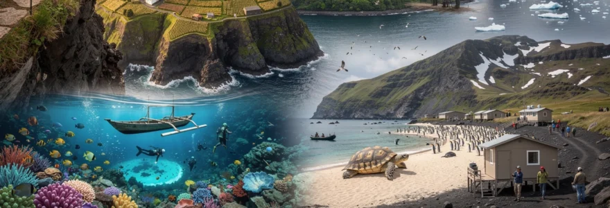
Remote atlantic archipelagos: azores, faroe islands and são tomé
The Atlantic Ocean harbours several archipelagos where geographical remoteness, challenging weather patterns, and limited transport infrastructure create natural barriers against excessive tourism. These island groups have developed sustainable tourism models that prioritise environmental preservation over visitor numbers, resulting in destinations that reward those willing to navigate their logistical complexities. The volcanic landscapes, unique cultural traditions, and endemic species found across these islands represent some of Europe and Africa’s most pristine ecosystems, maintained through both conscious policy and fortunate isolation.
Pico island’s volcanic landscape and UNESCO-Protected vineyards
Rising 2,351 metres above the Atlantic, Pico Mountain dominates Portugal’s Azorean archipelago with a presence that shapes both the island’s climate and its tourism patterns. The UNESCO World Heritage-designated vineyard landscape, created through generations of stone-walled cultivation plots called currais, produces wines with distinctive mineral profiles impossible to replicate elsewhere. These vineyards require manual labour for maintenance, limiting commercial wine production and creating an agricultural tourism model focused on small-scale experiences rather than industrial operations.
The island’s accommodation infrastructure deliberately remains small-scale, with approximately 500 tourist beds across guesthouses and rural properties rather than resort complexes. This capacity constraint, combined with limited ferry schedules and weather-dependent inter-island flights, naturally regulates visitor numbers. Most travellers arrive for mountaineering, whale watching expeditions, or wine tourism, activities that suit low-density visitation. The island’s permanent population of roughly 14,000 residents maintains traditional livelihoods in fishing, dairy farming, and viticulture, ensuring that tourism supplements rather than replaces the local economy.
Mykines island: puffin colonies and restricted daily visitor quotas
The westernmost inhabited island of the Faroe archipelago implements one of Europe’s strictest tourism management systems, capping daily visitors at approximately 300 during summer months. This quota system protects the island’s puffin colonies, which number approximately 70,000 breeding pairs and represent a critical North Atlantic seabird population. Access requires advance booking through a government-managed system, with ticket sales closing once capacity is reached, creating a planning barrier that effectively filters casual tourists.
The island’s single village of approximately 10 permanent residents maintains traditional grass-roofed houses and subsistence practices largely unchanged for centuries. A dramatic footbridge connects the village to the lighthouse and primary puffin viewing areas, requiring supervised crossings that further control visitor flow. This infrastructure limitation, combined with unpredictable Atlantic weather that frequently cancels ferry services, means many visitors who purchase tickets never actually reach the island. For those who do arrive, the experience offers unmediated wildlife encounters impossible at more accessible seabird colonies.
Príncipe island’s biosphere reserve and endemic species conservation
São Tomé and Príncipe’s smaller island received UNESCO Biosphere Reserve designation in 2012, recognising its exceptional biodiversity and low-impact development trajectory. The island’s 7,000 residents live primarily in the single town of Santo António, leaving the majority of the 136-square-kilometre island as primary rainforest habitat for endemic species including the Príncipe thrush, Príncipe sunbird, and several unique orchid varieties. Tourism infrastructure consists of fewer than 100 beds across eco-lodges and community guesthouses, with no conventional hotels or resorts permitted within the biosphere reserve zones.
Reaching Príncipe requires either a connecting flight from São Tomé (population 220,000
)
, or an expensive chartered flight, keeping arrival numbers in the low thousands per year. Strict zoning regulations prohibit large-scale coastal development and limit road construction, forcing most exploration to occur on foot or by boat with local guides. As a result, beaches remain undeveloped, and inland trails feel more like biological field sites than tourist paths. For travellers accustomed to crowded equatorial islands, Príncipe offers a rare chance to experience intact Gulf of Guinea ecosystems while directly supporting small community enterprises that depend on low-impact tourism rather than mass visitor turnover.
Flores island’s crater lakes and limited accommodation infrastructure
West of Pico, the Azorean island of Flores represents one of Europe’s most isolated territories, situated closer to North America than to mainland Portugal. The island’s name, meaning “flowers,” reflects its lush hydrangea-lined roads, but it is the string of volcanic crater lakes such as Lagoa Funda and Lagoa Rasa that define its interior landscape. Steep cliffs, cascading waterfalls like Poço do Bacalhau, and narrow coastal roads create a topography that naturally discourages large tour buses and cruise excursions. Instead, Flores attracts independent hikers, birdwatchers, and landscape photographers prepared for unpredictable Atlantic weather and limited services.
Accommodation on Flores remains intentionally sparse, with only a handful of small guesthouses, alojamento local rentals, and minimal hotel capacity, amounting to a few hundred beds at most. There are no large resorts, golf courses, or conference facilities, limiting the island’s appeal to mass-market operators seeking high-volume packages. Daily flight connections are few and often subject to cancellation due to fog or strong winds, meaning travellers must build flexibility into their itineraries and accept the possibility of being “weathered in.” Yet for those willing to embrace this uncertainty, Flores offers an island escape where hiking trails can remain empty for hours and night skies still reveal the full arc of the Milky Way without light pollution.
Indo-pacific coral atolls beyond commercial flight routes
Moving from the North Atlantic to the Indo-Pacific, a series of coral atolls and island clusters remain beyond the reach of conventional tourism infrastructure and scheduled jet services. Reaching many of these islands requires combinations of domestic propeller flights, cargo vessels, and locally operated boats rather than a single direct route. This logistical complexity acts like a natural filter, ensuring that only a fraction of travellers who dream of a remote island escape actually make the journey. The reward for those who do? Near-pristine coral reefs, small communities that still manage marine resources according to ancestral custom, and shorelines free of high-rise hotels and nightclub districts.
Palmerston atoll’s population of 35 and ancestral land management
Located in the Cook Islands, Palmerston Atoll is often cited as one of the world’s most isolated inhabited places, home to around 35 residents, most of whom are descendants of a single 19th-century settler. There is no airport; access is by infrequent supply ships or private yacht, making spontaneous tourism essentially impossible. Visitors anchor offshore and must request permission to land, with island families taking turns to host and manage the limited number of arrivals. This rotation system, rooted in ancestral land rights, ensures that any economic benefits from outsiders are shared fairly among the extended community.
Because Palmerston’s lagoon and reef are central to local subsistence, fishing and gathering activities follow customary rules rather than open-access exploitation. Lobster, parrotfish, and giant clams are harvested with an awareness that the community itself will suffer first if stocks decline, a stark contrast to many overfished reef destinations with transient visitor populations. You will not find dive shops, beach clubs, or spa resorts here; instead, experiences revolve around joining fishing trips, sharing meals of taro and fresh tuna, and listening to stories of storms and shipwrecks that shaped life on the atoll. For travellers seeking island escapes that remain untouched by mass tourism, Palmerston embodies what “remote” truly means in the 21st century.
Koh rong sanloem’s marine protected areas and seasonal access limitations
Off Cambodia’s southern coast, Koh Rong Sanloem sits just far enough from the mainland to escape the rapid resort development seen in more accessible beach destinations. While neighbouring Koh Rong has seen a surge in backpacker hostels and mid-range hotels, Koh Rong Sanloem remains quieter, with small bungalow operations tucked behind tree lines rather than lining the entire shoreline. Parts of the surrounding waters fall under marine protected area designation, limiting destructive practices such as trawling and dynamite fishing that have devastated reefs elsewhere in Southeast Asia. As a result, snorkellers and divers still encounter healthy coral gardens, seahorses, and bioluminescent plankton on night swims.
Monsoon-season storms and rough seas between approximately May and October regularly disrupt ferry services, turning what might appear as a simple island hop into a weather-dependent undertaking. Some smaller guesthouses close entirely during the wet season, while others operate with skeleton staff and reduced services, accepting fewer visitors instead of chasing volume at any cost. If you plan a trip, you need to factor in buffer days for potential delays and pack with power outages and limited mobile coverage in mind. The trade-off for this inconvenience is the ability to walk long stretches of sand without encountering jet skis, beach vendors, or neon-lit full moon parties.
Raja ampat’s remote dive sites and liveaboard-only accessibility
Indonesia’s Raja Ampat archipelago, often described as the global epicentre of marine biodiversity, offers some of the most spectacular coral reef diving on earth. Yet despite increasing international awareness, it remains relatively untouched by mass tourism due to its sheer remoteness and the need for specialised logistics. Reaching the main gateway town of Sorong usually involves multiple flights via Jakarta or Makassar, followed by ferries or dedicated transfer boats to individual islands. Many of the premier dive sites can only be reached by liveaboard vessels, which have limited berths and follow strict itineraries designed around seasonal conditions and conservation priorities.
Local authorities and indigenous communities have introduced a combination of marine park fees, no-take zones, and patrol systems funded partly by responsible dive tourism. Liveaboard operators are required to adhere to codes of conduct that limit anchoring on sensitive reefs, regulate diver group sizes, and prohibit feeding or harassing marine life. Because daily visitor numbers are constrained not by theoretical capacity but by the small fleet of boats and eco-resorts operating under these rules, even the most famous sites rarely feel crowded. Travellers who come to Raja Ampat are expected to respect local adat (customary law), treat freshwater as the scarce resource it is, and accept that high-speed Wi-Fi is far less available than manta cleaning stations and swirling barracuda schools.
For those willing to invest the time and cost required, Raja Ampat offers a textbook example of how remote island tourism can align with large-scale conservation goals rather than undermining them. It shows that “off the beaten path” is more than a marketing phrase here; it is an operational reality shaped by geography, policy, and community control. If you have ever wondered what coral reefs looked like before coastal overdevelopment and mass tourism, this is one of the few places where you can still see a close approximation.
Aldabra atoll’s giant tortoise sanctuary and research permit requirements
Part of the Seychelles but situated over 1,100 kilometres from Mahé, Aldabra Atoll is one of the largest raised coral atolls in the world and among the least disturbed. Its remoteness has protected a population of more than 100,000 giant tortoises, outnumbering humans by an almost unimaginable margin since there is no permanent civilian settlement. Aldabra’s lagoon and surrounding reefs provide critical habitat for sharks, manta rays, and nesting seabirds, while the atoll’s terrestrial environment supports unique plant communities adapted to harsh conditions. Recognised as a UNESCO World Heritage Site, Aldabra operates more like a living laboratory than a leisure destination.
Access is heavily restricted: there are no regular tourism cruises, no guesthouses, and no casual day trips from popular Seychelles beaches. Most visitors arrive on specially authorised expedition vessels or as part of scientific teams that must obtain research permits from the Seychelles Islands Foundation. Landing points are limited and strictly controlled to reduce disturbance, and walking routes are often confined to designated areas. For travellers who do secure a place on an expedition, activities focus on guided nature walks, snorkelling surveys, and educational briefings rather than conventional resort entertainment. Aldabra’s management model illustrates how an island can welcome a tiny number of highly engaged visitors each year while remaining effectively untouched by mass tourism pressure.
Sub-antarctic and polar island territories with scientific station access
At the frigid margins of the Southern Ocean, a cluster of sub-Antarctic and polar islands function primarily as research outposts rather than holiday destinations. Harsh climates, storm-lashed seas, and strict environmental regulations combine to keep annual visitor numbers extraordinarily low. When tourist ships do visit, they typically operate under expedition-style protocols with mandatory briefings, decontamination procedures, and tight caps on the number of people allowed ashore at any one time. These islands may not resemble the white-sand escapes most people imagine, but for travellers fascinated by megafauna, glaciology, and extreme environments, they offer some of the world’s most extraordinary—and least altered—island landscapes.
South georgia island’s king penguin colonies and expedition cruise protocols
South Georgia, a British Overseas Territory in the South Atlantic, is accessible only by multi-day sea voyages, most often as an extension of Antarctic Peninsula expedition cruises. The island’s rugged interior, dominated by mountains and glaciers, drops sharply into bays that host enormous king penguin colonies, some numbering over 100,000 breeding pairs. These gatherings create a living tapestry of sound and movement, with penguins, fur seals, and elephant seals sharing limited ice-free ground. It is here that you realise why strict visitor management is essential; a single careless group could trample nesting areas or introduce invasive species.
To reduce such risks, South Georgia enforces biosecurity checks, boot disinfection, and limitations on simultaneous shore landings, usually allowing no more than 100 passengers ashore at a site. Guides maintain set distances from wildlife, and marked walking routes keep human footprints within confined zones, much like carefully laid out museum paths through a priceless collection. Ships must apply for permits and follow pre-approved itineraries, and any breach of protocol can result in fines or future access being revoked. This framework ensures that while thousands of travellers now witness South Georgia’s wildlife each season, the experience remains controlled, low-impact, and far removed from mass tourism formats.
Kerguelen islands’ french research base and restricted landing zones
The Kerguelen Islands, often referred to as the “Desolation Islands,” lie in the southern Indian Ocean and belong to the French Southern and Antarctic Lands. With no indigenous population and only a rotating crew of scientists and technical staff at the Port-aux-Français research station, the archipelago functions almost entirely as a scientific outpost. Jagged peaks, vast windswept plains, and glacially carved fjords create an environment that is both starkly beautiful and profoundly inhospitable. You will not find tourist infrastructure, souvenir shops, or shore excursion desks here.
Access to Kerguelen is primarily via the French supply vessel Marion Dufresne, which services research bases a few times per year and occasionally allows a small number of paying passengers. Even then, landing opportunities are tightly controlled, with designated zones approved in advance based on wildlife sensitivities and weather conditions. Visitors must adhere to strict environmental protocols, including restrictions on where they can walk, what they can carry ashore, and how close they may approach animals. For those who undertake the long voyage, the Kerguelen Islands offer a rare chance to experience a landscape that feels more like a planetary outpost than a conventional island destination.
Macquarie island’s IUCN world heritage status and environmental monitoring
Situated in the Southern Ocean between Tasmania and Antarctica, Australia’s Macquarie Island is recognised as a World Heritage Site for its exceptional geological features and wildlife. Unique among sub-Antarctic islands, it exposes rocks from the Earth’s mantle above sea level, providing scientists with a window into plate tectonics that is normally hidden beneath the ocean floor. Its shores host vast colonies of royal penguins, king penguins, and various albatross species, as well as elephant seals that haul out in dense groups during breeding season. Such concentrations of wildlife make the island both a research hotspot and a fragile ecosystem requiring close oversight.
Tourism is limited to a small number of expedition ships each season, all operating under guidelines set by the Tasmanian Parks and Wildlife Service. Landing sites are carefully selected, and some areas remain off-limits to protect sensitive habitats and ongoing research projects. Visitors attend mandatory environmental briefings and must comply with decontamination procedures designed to prevent the spread of seeds or pathogens. Continuous environmental monitoring, including tracking vegetation recovery after the successful eradication of invasive rabbits and rodents, underpins decision-making about where and when people may go ashore. For travellers, this means accepting restrictions and strict schedules in exchange for the privilege of setting foot on one of the planet’s most carefully managed sub-Antarctic islands.
Mediterranean micro-islands with car-free policies and population caps
Closer to the European mainland, a number of micro-islands in the Mediterranean have taken deliberate steps to avoid the overcrowding that plagues some of the region’s better-known hotspots. Through car-free policies, population caps, and stringent building regulations, these islands have preserved human-scale environments where residents still outnumber tourists for most of the year. The absence of private vehicles changes the rhythm of daily life—streets become social spaces rather than traffic corridors, and distances are measured in walking minutes rather than driving time. For visitors, the result is a slower, more tactile experience of place, one in which historic architecture and traditional livelihoods retain centre stage.
Hydra island’s traditional architecture preservation laws
Hydra, one of Greece’s Saronic Islands, has long enforced a ban on private cars and motorcycles, relying instead on donkeys, water taxis, and human power for transport. This logistical limitation goes hand in hand with strict preservation laws that protect the island’s neoclassical mansions, stone alleys, and harbourfront from unsympathetic development. Building heights, facade colours, and even construction materials are regulated to maintain the visual harmony of the townscape. As a result, Hydra feels less like a typical Mediterranean resort destination and more like a living historical settlement where daily life unfolds within preserved architectural frameworks.
Tourist beds are finite, concentrated in small hotels, guesthouses, and restored mansions rather than large-scale complexes. Day-trippers do arrive from Athens during peak season, but the absence of cars keeps noise and congestion at manageable levels, especially in the evenings once boats depart. If you stay overnight, you will likely find yourself walking narrow lanes lit by house lanterns and the glow of tavernas rather than neon signage. While Hydra is far from undiscovered, its legal and physical constraints have prevented it from succumbing to the kind of mass tourism that transforms waterfronts into homogenised strips of bars and souvenir shops.
Gili meno’s motorcycle ban and low-impact tourism initiatives
In Indonesia’s Lombok region, Gili Meno sits between the busier islands of Gili Trawangan and Gili Air yet maintains a far more tranquil atmosphere. Local regulations prohibit motorised vehicles, meaning that transport is limited to walking, bicycles, and traditional horse-drawn carts known as cidomo. The lack of engine noise and fumes allows visitors to hear the sea and bird calls even in areas close to accommodation clusters. Coral restoration projects and turtle sanctuaries highlight the island’s commitment to low-impact tourism, with some local operators inviting guests to participate in reef clean-ups and conservation activities.
Gili Meno has deliberately avoided the dense bar scene and late-night parties associated with its neighbour Gili Trawangan, aiming instead at couples, divers, and travellers looking for a quiet island base. Power and freshwater supplies remain limited, naturally constraining the size and style of new developments. While simple beach bungalows and a few boutique properties exist, there are no high-rise structures or international chain hotels. For travellers, this means accepting a more rustic standard of comfort in exchange for the kind of peaceful, small-scale island environment that is increasingly rare in Southeast Asia’s more commercialised beach regions.
Procida island’s authentic fishing villages before UNESCO recognition
Before its selection as an Italian Capital of Culture and broader recognition by UNESCO-related initiatives, Procida in the Bay of Naples flew under the radar compared with nearby Capri and Ischia. Its colourful harbour of Marina Corricella, lined with pastel fishermen’s houses stacked almost like theatre scenery, remained primarily a working port rather than a luxury yachting hub. Narrow stairways and alleys climb the island’s volcanic slopes, revealing small piazzas where local residents gather and children play, often with few tourists in sight outside peak summer days. This everyday authenticity stems in part from the island’s limited accommodation capacity and lack of large-scale resort infrastructure.
Planning regulations historically favoured preserving existing building stock over greenfield hotel projects, keeping Procida’s built environment dense but low-rise and human in scale. Even as its profile rises, the physical constraints of the island—steep terrain, narrow streets, and finite waterfront space—make mass tourism unlikely to take hold in the same way it has on some larger Mediterranean islands. For now, visitors can still book rooms in small family-run guesthouses and wake to the sound of fishing boats heading out at dawn rather than to coach engines idling in hotel car parks. The challenge going forward will be maintaining this balance as cultural recognition increases demand, a tension that many “undiscovered” islands eventually face.
Southeast asian archipelagos with indigenous land rights and entry permits
Across Southeast Asia, several archipelagos have remained relatively untouched by mass tourism not just because of distance, but because indigenous communities retain legal and customary control over land and sea. Government-issued entry permits, seasonal closures, and community-level regulations shape who can visit and under what conditions. This framework stands in contrast to many coastal regions where rapid, investor-driven development has sidelined local voices. For travellers, it means that island escapes in these regions often involve more preparation and paperwork—but also deeper opportunities for cultural exchange and responsible travel.
Mergui archipelago’s moken sea nomad communities and government restrictions
The Mergui Archipelago in Myanmar comprises more than 800 islands scattered across the Andaman Sea, many of which remain uninhabited or home to small communities of Moken, often referred to as “sea nomads.” Decades of political isolation and security concerns kept the region almost entirely closed to foreign visitors, and even today, access is tightly regulated through government permits and licensed operators. Most travellers explore the area via liveaboard cruises or chartered boats that follow approved routes and anchorages. White-sand beaches, mangrove-fringed inlets, and coral reefs appear almost untouched, in part because industrial-scale tourism never had a chance to establish itself.
Moken communities traditionally followed a semi-nomadic lifestyle, spending much of the year on small boats and relying on extensive knowledge of tides, currents, and marine species. As state control has increased, many have been encouraged or compelled to settle in shore-based villages, but their customary rights and knowledge still play an important role in local resource management. Responsible operators prioritise engagement with Moken-led initiatives and avoid intrusive “village visits” that reduce culture to a spectacle. If you are considering a trip, it is essential to choose companies that respect government regulations and community preferences, accepting that the archipelago’s remoteness and political context make flexibility and patience part of the journey.
Togean islands’ coral triangle biodiversity and homestay-only lodging
Located in the Gulf of Tomini in central Sulawesi, Indonesia’s Togean Islands sit within the Coral Triangle, a region known for having some of the world’s highest marine biodiversity. Getting there typically involves a combination of domestic flights, long-distance buses, and overnight ferries, followed by smaller local boats—an odyssey that deters all but the most determined travellers. Once you arrive, you find a network of small islands where coconut palms, traditional wooden houses, and simple jetties replace large hotels and paved promenades. Coral reefs, seagrass beds, and mangroves lie within easy reach of shore, offering snorkelling and diving opportunities that feel like stepping into a natural aquarium.
Accommodation in the Togean Islands largely takes the form of homestays and small eco-lodges, often built on stilts above shallow lagoons. These operations are typically family-run, with set meal times and limited electricity, encouraging a slower daily rhythm aligned with daylight and tides. Many local communities have established informal rules about reef use, discouraging destructive fishing methods and promoting no-take zones around key dive sites. Because there are no large airports, cruise terminals, or all-inclusive resorts, the Togeans attract a relatively small, self-selected subset of travellers interested in low-impact stays rather than mass beach tourism. This model shows how homestay-only lodging can act as both an economic engine and a safeguard against overdevelopment.
Siargao island’s restricted development zones and surf break protection
Once a little-known surf destination in the Philippine Sea, Siargao has gained international attention in recent years, particularly for its world-class break at Cloud 9. Yet even as visitor numbers grow, local and national authorities have introduced measures to avoid the uncontrolled sprawl seen in other Southeast Asian surf towns. Certain coastal wetlands, mangrove forests, and offshore islets fall under protected status, limiting the construction of large hotels and commercial complexes. Zoning rules in key areas around General Luna and neighbouring barangays aim to channel development into designated corridors rather than allowing piecemeal building along every accessible shoreline.
Surf break protection comes in the form of regulations on boat traffic, restrictions on construction of artificial reef structures, and community-enforced etiquette in the water. Surf schools are required to follow safety protocols and limit student numbers to reduce crowding and accidents at popular peaks. While Siargao now offers a wide range of guesthouses and boutique hotels, road capacity, power infrastructure, and environmental oversight effectively cap how many visitors the island can handle at any one time. Travellers who come for the surf and stay for the lagoons, rock pools, and island-hopping tours quickly realise that the very qualities that drew them here—clean water, palm-fringed bays, and open horizons—depend on keeping mass tourism in check.
Arctic circle islands with climate-controlled visitation periods
At the northern edge of human habitation, islands within the Arctic Circle present an entirely different set of constraints on tourism. Extreme seasonality, shifting sea ice, and strict polar bear safety protocols limit when and how visitors can arrive. Rather than high and low seasons defined by school holidays, access windows here are determined by daylight hours, ice conditions, and the capacity of small communities to handle outside interest. For travellers seeking island escapes that remain untouched by mass tourism, these Arctic destinations offer stark, luminous landscapes where nature still dictates the rules.
Svalbard’s longyearbyen settlement and polar bear safety protocols
Svalbard, a Norwegian archipelago midway between mainland Norway and the North Pole, is one of the most accessible Arctic regions thanks to regular flights into its administrative centre, Longyearbyen. Yet despite this relative ease of access, the islands remain far from mass-market territory due to strict environmental regulations and the ever-present risk of encounters with polar bears. Outside designated safe zones around Longyearbyen, carrying a rifle or travelling with an armed guide is mandatory, underscoring that this is wilderness first and tourism destination second. Snowmobiles, boats, and dog sleds replace rental cars as the primary means of exploring beyond town.
Visitor numbers are managed through a combination of landing restrictions, protected areas, and rules governing cruise ship operations, including caps on passengers allowed ashore at certain sites. Tour operators must undergo certification and adhere to guidelines that limit wildlife disturbance and protect cultural heritage remains from early mining and polar expeditions. The long polar night and short, intense summer further control tourism flows, concentrating most activity into a few months when daylight is sufficient and sea ice retreats. For travellers, the result is an experience that may include seeing the northern lights, walking through glacial valleys, or visiting abandoned Soviet-era mining towns—without the crowds associated with more temperate attractions.
Jan mayen island’s norwegian military restrictions and volcanic activity
Jan Mayen, a remote Norwegian island in the Arctic Ocean, is dominated by the Beerenberg volcano, which rises over 2,200 metres and remains one of the world’s northernmost active volcanoes. The island hosts a small Norwegian military and meteorological station, with no permanent civilian population and no conventional tourism infrastructure. Access is limited to occasional scientific missions, supply flights, and a tiny number of expedition cruise landings authorised by Norwegian authorities. In many ways, Jan Mayen functions more like a restricted research site than an “island escape” in the conventional sense.
Landing permissions are tightly controlled, and most visitors must remain within designated coastal zones under the supervision of station personnel or licensed guides. Volcanic monitoring and sensitive Arctic ecosystems necessitate strict rules about where people can walk and what equipment they can bring ashore to avoid contamination. There are no souvenir shops, hotels, or cafes—only stark volcanic landscapes, black-sand beaches, and the imposing ice-clad cone of Beerenberg looming overhead. For the few travellers who do make it here, often as part of specialist geology or polar history expeditions, Jan Mayen offers an experience akin to visiting an off-limits scientific outpost rather than a tourist island.
Wrangel island’s UNESCO site and russian federal nature reserve status
Wrangel Island, situated in the Chukchi Sea and administered by Russia, is both a UNESCO World Heritage Site and a strict Federal Nature Reserve. Often called the “polar bear maternity ward of the Arctic,” it supports one of the highest densities of polar bear dens in the world, as well as large populations of walrus, musk ox, and migratory birds. Human presence is limited to a small contingent of rangers and researchers based at seasonal outposts, with no permanent civilian settlements. Permafrost landscapes, braided rivers, and tundra slopes dotted with wildflowers in summer give the island a remote, primordial character that few places on earth can match.
Tourism access is heavily regulated: a handful of expedition cruises each year receive permits to approach Wrangel, with shore landings allowed only under ranger supervision and in pre-approved locations. Group sizes are restricted, and visitors must follow strict wildlife viewing distances and waste management protocols. Sea ice conditions can change rapidly, sometimes preventing landings altogether even when permits are in place, reminding travellers that nature has the final say here. For those who do step ashore, the experience of standing on an island that remains almost entirely governed by ecological rather than economic considerations is a powerful reminder of what “untouched by mass tourism” can still mean in the modern world.


