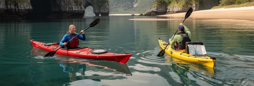
The allure of gliding silently through sheltered bays and discovering secluded coastal enclaves has captivated paddlers for generations. Kayaking in protected waters offers a unique perspective on marine ecosystems, combining the tranquillity of nature observation with the physical engagement of self-propelled watercraft navigation. These environments provide ideal conditions for developing advanced technique whilst minimising exposure to challenging sea states. Whether exploring flooded valleys rich in maritime history or navigating between karst formations in tropical waters, the appeal lies in accessing locations unreachable by conventional vessels. The growing popularity of calm water kayaking reflects a broader shift towards sustainable tourism and low-impact outdoor recreation that prioritises intimate environmental engagement over speed or distance.
Essential paddling techniques for sheltered coastal navigation
Mastering fundamental paddling mechanics forms the cornerstone of efficient and enjoyable kayaking experiences in protected waters. Whilst these environments may appear forgiving compared to open ocean conditions, proper technique significantly enhances control, reduces fatigue, and enables you to explore for extended periods without discomfort. The biomechanics of effective paddling involve coordinated movement patterns that engage core musculature rather than relying solely on arm strength. Understanding these principles transforms kayaking from an exhausting arm workout into a sustainable full-body activity that allows for hours of exploration through scenic waterways and coastal inlets.
Forward stroke biomechanics and torso rotation mechanics
The forward stroke represents the most frequently employed paddling motion, yet many recreational kayakers execute it inefficiently by pulling with their arms rather than rotating their torso. Proper forward stroke technique originates from the core muscles, with the torso rotating to plant the paddle blade whilst the opposite hand pushes forward across the centreline. This rotation generates significantly more power than arm muscles alone whilst distributing effort across larger muscle groups. The catch phase involves fully submerging the blade near your toes, followed by a smooth pull alongside the hull, ending when the blade reaches your hip. Research indicates that proficient paddlers generate approximately 70% of their propulsive force from torso rotation, whilst novices typically reverse this ratio, leading to premature fatigue and reduced speed.
Sweep strokes and stern rudder control in confined spaces
Navigating narrow channels, manoeuvring around moored vessels, and exploring the intricate geography of hidden coves requires precise directional control beyond simple forward paddling. The sweep stroke accomplishes sharp directional changes by describing a wide arc from bow to stern on one side of the kayak, with the paddle blade held at a shallow angle to the water surface. A forward sweep on the right side turns the bow left, whilst a reverse sweep on the right turns the bow right. For more subtle course corrections whilst maintaining momentum, the stern rudder technique proves invaluable. By trailing the paddle blade vertically in the water behind your hip and angling it slightly away from or towards the hull, you create a continuous steering effect without interrupting your forward motion—particularly useful when approaching landing sites or navigating through confined passages between rock formations.
Bracing techniques for stability in glassy water conditions
Paradoxically, perfectly calm water can present stability challenges for kayakers accustomed to relying on subtle wave action for balance feedback. The low brace and high brace techniques provide instant stability recovery when you feel your balance shifting unexpectedly. The low brace involves slapping the back face of the paddle blade flat on the water surface whilst your knuckles point downward, creating immediate downward pressure that arrests a capsize. The high brace employs the power face of the blade with knuckles pointing upward, offering greater leverage but requiring more precise timing. In glassy water conditions, anticipatory low braces can prevent capsizes during activities like wildlife photography or when reaching for equipment. Practising these techniques in shallow, warm water builds the muscle memory that proves invaluable during unexpected stability challenges in more remote locations.
Low-angle vs High-Angle paddle blade positioning
The angle at which you position your paddle shaft relative to the water surface significantly influences paddling efficiency, muscle recruitment, and suitability for different kayaking styles. Low-angle paddling maintains the paddle shaft at approximately 20-30 degrees to the water surface
and favours a relaxed cadence suitable for long-distance touring on calm lakes and sheltered coves. This low-angle style reduces strain on the shoulders and wrists, making it ideal for recreational paddlers who prioritise comfort and energy conservation over raw speed. High-angle paddling, by contrast, brings the shaft closer to vertical (around 60–70 degrees) and places the blade nearer the kayak’s hull, generating more powerful strokes and quicker acceleration. The trade-off is increased muscular demand and a slightly higher likelihood of blade splash, which may disturb wildlife in very quiet environments. For most sheltered coastal navigation, you may find a hybrid approach works best—using low-angle strokes for relaxed crossings and transitioning to high-angle bursts when you need extra manoeuvrability in narrow channels or when punching through light headwinds.
Premium kayaking destinations for tranquil water exploration
Calm-water kayaking shines brightest in destinations where sheltered inlets, hidden coves, and protected bays create natural havens from ocean swell. Around the world, marine parks, fjord systems, and inland seas offer glassy conditions that are perfect for refining technique whilst immersing yourself in spectacular scenery. When you plan a kayaking adventure in calm waters and hidden coves, it is worth considering not just the postcard views but also factors like access, local regulations, and seasonal weather patterns. Some locations reward early-morning paddlers with mirror-flat conditions and wildlife encounters, whilst others come into their own at slack tide when currents ease. Below, we explore several world-class destinations where sheltered coastal navigation and tranquil water exploration come together.
Channel islands national park sea caves and painted cave
Off the coast of Southern California, Channel Islands National Park offers a network of sea caves, kelp forests, and protected coves that feel a world away from the mainland. The star attraction for many paddlers is Painted Cave on Santa Cruz Island, one of the largest and deepest sea caves in the world, extending over 370 metres into the cliff. On calm days with low swell, experienced kayakers can paddle into the cave’s twilight zones, where mineral-stained rock walls glow with reds, yellows, and greens that inspired its name. Accessing these sea caves safely demands careful timing around wind, swell, and tide—you will want to avoid days with significant surf or onshore winds, which can funnel waves into narrow entrances like a natural wave machine. Many visitors opt for guided tours with local outfitters who provide sea kayaks, safety gear, and local knowledge about marine wildlife, including sea lions, harbour seals, and migrating whales.
For those seeking quieter water away from surge-prone cave entrances, the leeward sides of Santa Cruz and Anacapa Islands often provide ideal conditions for sheltered paddling. Kelp beds act like underwater breakwaters, smoothing the surface and creating calm lanes that are perfect for practising sweep strokes and bracing techniques. You may find yourself gliding over forests of giant kelp where bright orange Garibaldi fish dart between fronds, offering a vivid reminder of the rich coastal ecosystems that thrive in protected marine areas. Because the Channel Islands lie within a national park and marine sanctuary, regulations limit landing sites and protect sensitive breeding areas, so it is crucial that you follow Leave No Trace principles and respect seasonal closures. Planning your route around ferry schedules, park permits, and weather forecasts ensures that your Channel Islands kayak trip feels like an immersive expedition rather than a rushed excursion.
Milford sound fiordland and doubtful sound paddling routes
In New Zealand’s South Island, Fiordland National Park offers some of the most dramatic yet surprisingly sheltered paddling environments on the planet. Milford Sound and Doubtful Sound are classic examples of deep glacial fjords where steep mountain walls shield the water from prevailing winds, often resulting in glassy, reflective surfaces. In Milford Sound, kayakers can paddle beneath sheer cliffs that rise over 1,000 metres almost vertically from the sea, passing beneath waterfalls like Stirling and Bowen Falls that cascade directly into the fjord. The sheltered character of the inner sound makes it ideal for beginners seeking calm water, whilst more experienced paddlers can venture further towards the mouth, where swell and wind become more pronounced. Doubtful Sound, accessible only by a combination of bus and boat, offers an even more remote experience with fewer vessels and a strong sense of isolation that amplifies every sound of paddle blades dipping into the water.
Weather in Fiordland is famously changeable, with over 200 days of rain each year, yet this high rainfall is precisely what creates the area’s signature two-layer water system. A thin layer of dark, tannin-stained freshwater floats atop denser saltwater, reducing light penetration and creating unique marine habitats—including black corals typically found at much greater depths. Paddlers must be prepared for sudden showers and shifting winds, but these micro-climate variations often come with rewards such as ephemeral waterfalls cascading down every rock face. Local operators provide stable sea kayaks, dry gear, and guided routes through the quieter arms and side-coves where the water remains sheltered even when conditions outside the fjord are rough. If you are planning self-guided trips, it is wise to study tide tables, marine forecasts, and recommended launch windows, as some landings become challenging at low water due to sharp barnacle bands and slippery rock shelves.
Halong bay karst formations and floating village access
On Vietnam’s northern coast, Halong Bay’s labyrinth of limestone karsts and sheltered channels has made it a flagship destination for calm-water kayaking holidays. Over 1,600 islands and islets rise abruptly from the water, creating maze-like passages, hidden lagoons, and sheltered coves that feel tailor-made for small craft exploration. Many traditional junk-boat cruises now include kayaking as a core activity, allowing you to leave the main vessel and slip into quiet lagoons through low sea arches and narrow rock gates. Once inside these enclosed basins—sometimes only accessible at mid-to-high tide—the water often becomes perfectly still, providing a serene environment for observing birdlife and intricate stalactite formations. Because motorboats cannot reach many of these hidden spots, kayakers enjoy a rare sense of exclusivity and tranquillity even in a busy tourism hub.
Kayaking in Halong Bay also offers a window into local culture, particularly around the traditional floating fishing villages that still dot parts of the bay. While some villages have transitioned towards tourism and aquaculture, others maintain long-standing fishing practices that have adapted to the bay’s sheltered conditions and tidal rhythms. Ethical paddling here means keeping a respectful distance from homes and work areas, avoiding intrusive photography, and following your guide’s advice on culturally appropriate behaviour. The bay’s semi-enclosed geography can sometimes trap haze and humidity, giving the scenery a dreamlike, muted palette best appreciated at slower paddling speeds. Tidal planning is crucial for routes that involve passing under rock arches or into interior lagoons—arriving at the wrong time can mean either scraping over sharp barnacles or finding the passage completely blocked by exposed rock.
Scottish highlands lochs: loch lomond and loch ness protected bays
The Scottish Highlands deliver a very different kind of calm-water kayaking adventure, where freshwater lochs framed by rugged hillsides provide a blend of wilderness and accessibility. Loch Lomond, part of Loch Lomond & The Trossachs National Park, offers multiple sheltered bays and island-dotted sections that are ideal for beginners and families. The loch’s southern end is wide and relatively shallow, with beaches and marinas that make launching straightforward even for first-time paddlers. As you move north, the scenery becomes more dramatic, with narrower reaches and steepening hillsides, yet numerous inlets remain protected from prevailing winds. Kayaking among the loch’s 30-odd islands allows for short crossings punctuated by rest stops on wooded shores, a perfect setting to practise navigation, ferry glides, and low-angle paddling on calm water.
Loch Ness, by contrast, is long, deep, and more exposed, but still offers secluded pockets where the water lies flat despite breezy conditions in the main channel. Small bays such as those near Dores or Foyers can remain sheltered thanks to headlands that break up wind and wave action, providing safe training grounds for edging and bracing skills. Given Scotland’s variable weather, layering and dry storage are essential: even on sunny days, a sudden shower or katabatic breeze sliding down a glen can drop temperatures rapidly. Access rights under Scotland’s outdoor access code make it easier to launch from many points along the shore, provided you respect private property and avoid disturbing wildlife or livestock. For paddlers interested in multi-day lake touring, the Highlands’ network of lochs and canals—including the Caledonian Canal linking Loch Ness with neighbouring waters—offers extended routes with a mix of sheltered and semi-exposed sections.
Abel tasman national park golden beaches and tidal lagoons
On New Zealand’s north South Island coast, Abel Tasman National Park is renowned for its golden sand beaches, turquoise water, and reliable summer weather patterns that favour calm-water paddling. The coastline is indented with crescent-shaped bays and headlands that provide natural shelter from prevailing swells, creating a series of short, manageable crossings interspersed with protected landings. Many of the park’s signature lagoons—such as those at Torrent Bay and Sandfly Bay—are strongly influenced by tides, filling with water at high tide and draining to reveal sandflats and channels at low tide. For kayakers, this creates exceptional opportunities to paddle over shallow, sun-warmed water where marine life is easy to spot, provided you time your visit around mid to high tide. When the tide drops, some lagoon entrances become dry or turbulent, underscoring the importance of understanding tidal windows in apparently tranquil environments.
Abel Tasman’s clear water and sheltered coves make it an excellent classroom for refining forward stroke biomechanics, edging, and rescue skills in comfortable conditions. Wildlife encounters are common, with fur seals, shorebirds, and occasionally dolphins frequenting the inshore zone, particularly near offshore islands like Adele and Tonga. The park operates under a well-developed permitting and concession system, so guided trips, water taxis, and campsite bookings must be planned in advance during peak season. Because the coastal track parallels much of the paddling route, combination hike-and-kayak itineraries are popular, allowing you to paddle one section and walk another. This blend of reliable weather, accessible logistics, and sheltered water has made Abel Tasman one of the Southern Hemisphere’s premier destinations for calm-water sea kayaking holidays.
Sit-on-top versus sit-inside kayak selection for protected waters
Choosing between a sit-on-top and a sit-inside kayak for calm coastal waters is a bit like choosing between a convertible and a saloon car—both can take you on the same journey, but the experience and comfort trade-offs differ. Sit-on-top kayaks offer open, self-bailing decks that are extremely forgiving for new paddlers, making re-entry after a capsize straightforward and low-stress. In warm climates and sheltered bays, this design is particularly appealing because you can slide off for a swim, scramble back on, and continue exploring without complex rescue techniques. However, sit-on-tops often sit higher on the water and catch more wind, which can make them slightly slower and more susceptible to being pushed off course in breezy conditions. Storage is typically on-deck in wells or dry bags, so you need to think carefully about waterproofing when planning longer calm-water kayaking adventures.
Sit-inside kayaks, by contrast, provide a closed cockpit that envelops your lower body, improving connection with the boat and allowing more efficient power transfer through your hips and thighs. In cooler climates or shoulder seasons, the ability to pair a sit-inside kayak with a spraydeck dramatically improves warmth and dryness, expanding your comfortable paddling window. For sheltered coastal navigation that occasionally skirts open stretches or encounters small wind chop, the lower profile and usually finer hull shape of a sit-inside design can feel more composed and responsive. The trade-off is that capsize recovery requires more training; you will need to be familiar with wet exits and assisted or self-rescue techniques, particularly if paddling beyond swimming distance from shore. For many paddlers, the decision comes down to how and where they intend to use their kayak most often—hot, shallow coves with frequent swimming favour sit-on-tops, while longer exploratory journeys in mixed weather lean towards sit-inside touring or sea kayaks.
Tidal pattern analysis and launch window optimisation
Even in seemingly placid coves and sheltered inlets, tides exert a powerful influence on water depth, current speed, and access to hidden features such as sea caves and inland lagoons. Understanding how to read tide tables and anticipate local tidal behaviour turns an average paddle into a well-timed, energy-efficient journey. When you synchronise your launch and landing with favourable tidal currents, you effectively harness a moving conveyor belt of water rather than fighting against it. Conversely, misjudged timing can turn a tranquil channel into a draining slog, especially where currents accelerate around headlands or through constricted entrances. Effective launch window optimisation is therefore as much a part of calm-water trip planning as checking the weather forecast and packing appropriate safety equipment.
Spring tide versus neap tide impact on cove accessibility
Many sheltered coves, sea caves, and tidal lagoons are only accessible during specific parts of the tidal cycle, and the difference between spring and neap tides can dramatically change what you can reach. Spring tides, which occur roughly every two weeks around new and full moons, produce the largest tidal range and therefore the greatest variation in water depth. During a large spring high tide, kayak-accessible routes may open into hidden basins behind sandbars or allow you to glide over otherwise exposed reefs, revealing a secret network of calm channels. Yet that same spring low tide can strand unwary paddlers in shallow mudflats or leave cave entrances high and dry, forcing long portages or re-routing. Neap tides, associated with quarter moons, have a smaller range, which often means more predictable access windows but fewer extreme opportunities for accessing very shallow features.
For calm-water kayaking holidays that focus on exploration of hidden coves, it is often wise to consult local guides or charts to identify which features are tidal-dependent. Some lagoons only remain safely navigable for an hour or two either side of high water, and arriving late can mean dealing with faster ebb currents funnelling through narrow entrances. In estuarine environments, spring tides may also produce stronger currents even several kilometres inland, subtly increasing your paddling effort on what appears to be flat water. By plotting your intended route against predicted tide heights and times, you can plan to visit the most tide-sensitive locations when conditions are most forgiving. This approach not only enhances safety but also maximises the tranquillity of your experience, as you are less likely to share those ephemeral lagoons and coves with larger vessels constrained by deeper drafts.
Slack water timing for current-free paddling sessions
Slack water—the period when tidal current slows to a near standstill as the tide turns—can feel like nature’s invitation to relaxed, current-free paddling. In many harbours, estuaries, and narrow channels, current strength builds towards mid-tide and then tapers off as high or low water approaches, creating a short window of almost motionless surface conditions. For kayakers exploring calm inlets or passing through constricted passages, planning to arrive near slack can significantly reduce the effort required and minimise the risk of being swept towards hazards. How long does slack water last? It depends on local geography, but in many areas the most benign period is 30–60 minutes either side of the official high or low water time listed in tide tables. However, peak slack may be offset from those times where channels or basins constrict or delay the flow.
For beginners and intermediate paddlers, scheduling crossings of harbour entrances, river mouths, or ferry lanes during slack water is one of the simplest ways to enhance safety without sacrificing adventure. You will notice the difference when eddies flatten, standing waves dissipate, and your boat tracks straight without constant corrective strokes. In some fjord and lagoon systems, slack water also coincides with the best visibility for wildlife observation, as sediment stirred up by strong currents has time to settle. When planning a calm-water kayaking day trip, it can be helpful to work backwards from your ideal slack crossing time to determine when you should launch. This disciplined approach may mean early starts or late returns, but the reward is unhurried paddling that lets you focus on scenery and technique rather than constant current management.
Nautical chart interpretation and bathymetric contour reading
Nautical charts may seem like tools reserved for yacht captains, yet for serious kayakers they are invaluable for understanding how underwater topography influences calm-water paddling. Bathymetric contours—the lines showing depth—reveal where shallow shelves transition to deeper basins, where submerged ridges could create tide races, and where gently shelving beaches offer safe landing spots at different tide heights. In sheltered coves and bays, closely spaced contours often indicate steep drop-offs that can concentrate currents, even when the surface appears placid. Wider-spaced contours, on the other hand, suggest gradual slopes that are more forgiving if you misjudge the tide and need to haul your kayak further up the beach. By learning to read these patterns, you effectively gain a three-dimensional mental model of the paddling environment.
Charts also mark navigational hazards, such as rocks awash, sandbars, and wrecks, which might not be visible at higher tides despite their potential to snag a kayak hull. In calm, clear water, you can sometimes cross shallow features safely, but you need to be confident that you will not become trapped behind them as the tide falls. Interpreting chart symbols for buoys, beacons, and shipping channels helps you anticipate where boat traffic is likely to be concentrated, allowing you to plan quieter, more tranquil routes. Many modern charts are available in digital form with GPS integration, giving you real-time position updates overlaid on depth and hazard information. Treat these tools as aids rather than substitutes for situational awareness; combining visual observation with chart interpretation creates a more resilient approach to coastal navigation in protected waters.
Admiralty tide tables and mobile prediction applications
Traditional Admiralty tide tables remain a gold standard for accurate tidal predictions in many parts of the world, offering authoritative reference data for high and low water times and heights at standard and secondary ports. For kayakers planning detailed calm-water trips, these tables provide the baseline from which you can estimate current strength, slack water windows, and access to tide-dependent features. The learning curve is similar to developing basic chart-reading skills: at first it may feel technical, but with practice you will quickly be able to identify favourable paddling windows at a glance. In the last decade, mobile applications and web-based services have made this information more accessible, layering graphical tide curves, current arrows, and even colour-coded risk levels on interactive maps. Many apps also account for daylight savings time automatically and offer offline caching, which is particularly useful in remote fjords or island chains with patchy reception.
However, the convenience of mobile tide prediction tools should not distract from the importance of cross-checking data sources and understanding their limitations. Not all apps incorporate the latest harmonic constants or local corrections, and some may round times or heights in ways that are acceptable for beachgoers but less ideal for route planning. A robust approach combines the reliability of official tide tables with the usability of modern apps, using the former as a reference and the latter for on-the-water confirmation. Before embarking on a multi-hour exploration of hidden coves, it is wise to screenshot tide graphs and note critical times in a waterproof notebook or on your deck chart. This redundancy ensures you retain situational awareness even if batteries fail or devices become waterlogged, maintaining the calm, unhurried character that defines safe sheltered-water kayaking.
Wildlife observation ethics in secluded coastal ecosystems
One of the great rewards of exploring calm waters and hidden coves by kayak is the opportunity to observe wildlife at close quarters, often in complete silence. Yet this same intimacy carries a responsibility to minimise disturbance, particularly in sensitive breeding or feeding areas. As a low-profile craft, kayaks can approach birds, seals, and other marine life far more closely than larger boats without being seen or heard until the last moment. Without clear guidelines, it can be tempting to edge ever closer in search of the perfect photograph, but doing so risks flushing animals from nests, interrupting feeding, or causing them to expend precious energy escaping. Ethical wildlife watching in secluded coastal ecosystems centres on giving animals the space and time they need to behave naturally, treating your presence as that of a discreet guest rather than an intrusive spectator.
A practical rule of thumb is to adopt a “bubble of respect” around any animal you encounter, typically at least 50 metres for seals and sea lions, and even more during pupping or moulting seasons when they are particularly vulnerable. If you notice changes in behaviour—such as birds taking flight repeatedly, seals lifting their heads in alarm, or dolphins altering course to avoid you—it is a clear sign you are too close and should back away using slow, predictable paddle strokes. Whenever possible, approach wildlife from the side rather than head-on, and avoid encircling animals or blocking their route to open water. In nesting colonies or rookeries, it is often best to pass by steadily rather than loiter, reducing cumulative disturbance for the colony as a whole. Remember that while a single close approach may seem harmless, popular calm-water routes can see many kayaks each day, and the combined impact of repeated disturbance can be significant.
In many marine protected areas, local regulations specify minimum approach distances and seasonal closures for certain coves or islands, designed to protect breeding birds or haul-out sites. Before launching, take time to familiarise yourself with these rules—often posted at access points or outlined on park websites—and integrate them into your route planning just as you would tide or weather data. Responsible paddlers also consider noise and light pollution: loud conversations, music, or high-powered torches at dusk can disrupt wildlife even when you maintain physical distance. Instead, use the natural quiet of sheltered coves to enhance your experience, listening for bird calls, surfacing breaths, and the subtle sounds of foraging along the shoreline. By adopting a wildlife-first mindset, you not only help preserve fragile coastal ecosystems but also cultivate more meaningful, unhurried encounters that align with the ethos of calm-water kayaking.
Meteorological conditions and micro-climate assessment for sheltered paddling
While calm bays and coves often feel insulated from the full force of ocean weather, they are still shaped by subtle meteorological patterns that can transform conditions over the course of a single day. Understanding how wind, temperature gradients, and local topography interact allows you to anticipate changes rather than react to them, a key skill when planning safe kayaking adventures in calm waters and hidden coves. Sheltered areas can sometimes amplify specific hazards: katabatic winds funnelled down steep valleys, sudden fog banks rolling through inlets, or gusts accelerating around headlands. Reading marine forecasts is essential, but learning to interpret on-the-water cues—such as ripples moving across previously glassy surfaces or cloud formations signalling incoming fronts—adds a real-time layer of decision-making. Ultimately, the goal is not to avoid all weather variation, but to select conditions that match your skill level and desired experience.
Beaufort scale wind force classification for kayaking safety
The Beaufort scale, originally developed for sailing ships, remains a practical framework for translating forecast wind speeds into real-world paddling conditions. For sheltered coastal navigation, many coaches recommend that novice kayakers stick to Beaufort Force 2 or below (light breeze up to 6–7 knots), when ripples form on the water but small craft remain easy to control. At this level, calm-water routes retain their tranquil character, and you have ample opportunity to practise efficient forward strokes and manoeuvres without battling wind-driven drift. As conditions reach Force 3 (gentle breeze, 7–10 knots), small wavelets and occasional whitecaps begin to appear even in partially sheltered areas, making high-angle strokes, edging, and bracing more relevant. For many recreational paddlers, Force 3 in exposed sections is an upper comfort limit, especially when combined with outgoing tides or adverse currents.
Beyond Force 3, even protected waters can quickly feel busy, with reflected waves bouncing off cliffs and breakwaters to create confused chop. Force 4 (moderate breeze, 11–16 knots) may still be manageable for experienced paddlers in well-designed sea kayaks, but it erodes the relaxed, glassy quality that defines calm-water kayaking holidays. When assessing forecasts, remember that reported wind speeds are often averaged over ten minutes and measured at standard heights, whereas gusts funnelling through valleys or around headlands can exceed these figures significantly. A conservative planning approach treats the forecast as a baseline and considers local amplifying factors, such as funnelling effects or thermal breezes. By matching the Beaufort range to your skills and staying within a comfortable margin, you preserve the sense of ease and control that makes sheltered paddling so appealing.
Fog formation in coastal inlets and visibility protocols
Fog is one of the most insidious weather phenomena for kayakers because it can descend quickly, drastically reducing visibility in otherwise calm and benign conditions. Coastal inlets and estuaries are particularly prone to advection fog, which forms when warm, moist air moves over cooler water, causing condensation. In these situations, you may launch into clear skies only to find distant headlands fading within an hour as a white curtain creeps inland. For paddlers exploring hidden coves or intricate shorelines, losing visual reference points can make navigation challenging, even when the water remains flat and windless. Suddenly, features that had been reassuring markers—like a particular rock outcrop or tree line—merge into a uniform grey horizon, and the risk of disorientation or accidental entry into shipping lanes increases.
Effective visibility protocols start long before fog appears, by equipping your kayak with basic safety gear such as a compass, chart or GPS, whistle, and light-coloured or reflective clothing. When forecasts mention possible fog, plan conservative routes that hug the shoreline and avoid crossing wide, open bays where losing sight of land could be dangerous. If fog begins to build, ask yourself: can we still safely identify our position and maintain a clear route to shore? If the answer is uncertain, the prudent choice is often to shorten the trip and head for a nearby landing rather than pressing on. In some regions, sound signals from buoys, foghorns, or passing vessels can provide additional orientation cues, but they are no substitute for visual references. By treating deteriorating visibility with the same seriousness as increasing wind, you maintain control over your risk exposure in otherwise deceptively calm environments.
Thermal wind patterns and katabatic flow in fjord systems
Fjord systems and steep-sided coastal valleys often exhibit pronounced thermal wind patterns, where temperature differences between land and sea generate predictable daily breezes. On sunny days, land heats faster than water, causing air to rise over the shore and draw cooler marine air inland—creating an afternoon sea breeze that can oppose your return leg if you paddled out in the morning calm. In the evening or on clear nights, the process reverses as cool, dense air drains downslope under gravity, producing katabatic winds that can accelerate dramatically through narrow fjords. These downslope flows may arrive suddenly, transforming a mirror-like surface into short, steep chop aligned with the valley axis, challenging kayakers caught far from sheltered bays or landing options.
Planning calm-water trips in fjords and similar topography means thinking in terms of daily wind cycles rather than just static forecast values. Many experienced paddlers choose to launch early, riding gentle morning tailwinds up-fjord and returning before afternoon sea breezes peak. When you study local guidebooks or talk to resident paddlers, you will often hear about “usual wind directions” at different times of day—anecdotal yet valuable information for timing your outings. Recognising visual cues such as dust or spray lifting from ridge lines, ripples marching steadily down the fjord, or flags stiffening at shoreline cabins can provide early warning of strengthening katabatic flow. By aligning your route choices with these micro-climate tendencies, you preserve the calm, contemplative character of your sheltered-water experience and avoid being surprised by abrupt, topographically driven winds.


