There’s something profoundly transformative about setting your alarm for an ungodly hour, lacing up your boots in darkness, and ascending a mountain trail with nothing but a headtorch to guide you. The reward? That singular moment when the sky transitions from inky black to soft pastels, then explodes into brilliant oranges and golds as the sun breaks the horizon. Sunrise hiking has become increasingly popular among outdoor enthusiasts, not simply for the photographic opportunities, but for the meditative quality of witnessing the world’s daily rebirth from an elevated vantage point. Whether you’re drawn to volcanic calderas, alpine peaks, or coastal cliffs, each sunrise hike offers a unique perspective on nature’s most reliable spectacle. The trails we’ll explore demand varying levels of physical commitment and technical skill, but they all share one common thread: the unforgettable sensation of achievement that comes from greeting the new day from somewhere extraordinary.
Pre-dawn alpine ascents: mount rinjani’s crater rim trek and half dome’s cable route
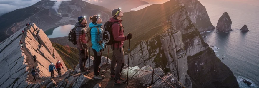
Alpine sunrise hikes represent the pinnacle of pre-dawn trekking experiences, combining significant elevation gain with technical challenges that test even experienced hikers. These high-altitude routes demand careful planning, proper acclimatisation, and respect for rapidly changing mountain weather. The payoff, however, is witnessing sunrise from positions that most people will never experience, where you’re literally standing above the clouds as daylight floods the valleys below.
Mount rinjani summit trail navigation and plawangan senaru crater viewpoint timing
Indonesia’s Mount Rinjani towers 3,726 metres above Lombok, making it the country’s second-highest volcano and one of Southeast Asia’s most challenging trekking destinations. The Plawangan Senaru crater rim serves as the primary sunrise viewing platform, positioned at approximately 2,700 metres elevation. Most guided expeditions begin the summit push around 2:00 AM, allowing three to four hours to navigate the steep scree slopes that characterise the final approach. The volcanic sand underfoot can feel like climbing through quicksand, with every step forward resulting in a half-step slide backwards. This section typically covers just 1.5 kilometres horizontally but gains nearly 600 metres in elevation, creating gradients that exceed 35 degrees in places.
Trail navigation on Rinjani becomes particularly crucial during the pre-dawn hours when visibility drops to whatever your headtorch can illuminate. The path isn’t always clearly marked, and the volcanic landscape offers few distinctive features to orient yourself. Local guides prove invaluable here, as they’ve memorised the route through countless ascents and can identify subtle landmarks invisible to first-time climbers. Weather conditions on the crater rim can shift dramatically within minutes, with temperatures dropping to near freezing before sunrise despite Lombok’s tropical location. Wind speeds frequently exceed 40 kilometres per hour at the summit, creating wind chill factors that make proper layering absolutely essential for comfort and safety.
Half dome permit system and sub dome granite switchback approach
Yosemite’s iconic Half Dome presents an entirely different alpine challenge, combining strenuous hiking with technical cable-assisted climbing. The National Park Service limits daily access through a strict permit lottery system, with approximately 300 permits available per day during the May-to-October hiking season. Successful applicants face a round-trip distance of 22 kilometres with 1,463 metres of cumulative elevation gain, typically requiring 12-14 hours to complete. Sunrise attempts add considerable complexity, as you’ll need to navigate the notorious cable section in darkness or pre-dawn twilight, which significantly increases risk factors.
The Sub Dome section, reached after approximately 11 kilometres of hiking, features approximately 600 granite steps carved directly into the rock face. These switchbacks gain 122 vertical metres in less than 200 horizontal metres, creating one of the trail’s most physically demanding segments. Your quads will burn, your lungs will labour in the thinner air at 2,590 metres elevation, and you’ll question your life choices. But reaching the cable section marks the psychological turning point where the summit suddenly feels achievable. The cables themselves extend 122 metres up the dome’s final 45-degree granite face, with wooden planks placed every few metres to provide
wooden footholds and brief resting points. For a sunrise ascent, factor in extra time for this section, as congestion and cautious movement in the dark can slow your pace considerably. Gloves with good grip are essential on the often cold, damp cables, and many hikers choose to clip into the steel lines with a via ferrata lanyard for additional security.
Because of the exposure and objective hazards, a sunrise Half Dome hike is best suited to experienced hikers confident with heights and route-finding under headtorch light. Start no later than midnight from Yosemite Valley if you plan to catch first light from the summit, and build in generous buffers for photo stops, snack breaks, and cable queues. Always monitor weather forecasts closely; afternoon thunderstorms are common in summer, and being high on an exposed granite dome with metal cables during lightning is a serious risk. If conditions deteriorate, be prepared to turn around before the cables, no matter how tempting that sunrise view might be.
Altitude acclimatisation protocol for high-elevation sunrise trailheads
Many of the world’s most memorable sunrise hikes begin at or climb above 2,500 metres, where altitude sickness becomes a genuine concern. To give your body time to adapt, follow a simple acclimatisation protocol whenever possible: sleep low, hike high, and increase your sleeping elevation by no more than 300–500 metres per night once above 2,500 metres. If you’re flying in from sea level, spending at least one or two nights in an intermediate-altitude town before attempting a high trailhead dramatically reduces your risk of acute mountain sickness.
Typical early signs of altitude issues include headache, nausea, loss of appetite, and unusual fatigue, all of which can be exacerbated by a pre-dawn start and lack of sleep. You can mitigate these symptoms by hydrating consistently (aim for 3–4 litres per day in dry mountain climates), avoiding alcohol before your hike, and keeping your pace conversational rather than competitive. For ambitious objectives like Mount Rinjani or other 3,000-metre-plus peaks, some hikers consult a doctor about prophylactic medications such as acetazolamide, though these are not a substitute for proper acclimatisation. Most importantly, adopt a conservative mindset: if symptoms worsen as you climb, descending is the only safe choice, no matter how close sunrise feels.
Headtorch lumens requirements and trail marker visibility assessment
On sunrise hikes, your headtorch is effectively your lifeline for the first hour or two, so treating it as essential safety gear rather than a last-minute add-on is crucial. As a rule of thumb, choose a headlamp with at least 200–300 lumens for well-marked forest or park trails, and 350–450 lumens for alpine routes with loose rock, steep scree, or poorly defined paths. Higher output provides better depth perception and allows you to scan for cairns, reflective markers, or junction signs without constantly stopping to peer into the darkness.
Before you commit to a pre-dawn ascent, research how well the route is marked and what kind of terrain you will encounter. Are there painted blazes on trees, rock cairns every 20–30 metres, or reflective signposts at junctions? Or will you be relying primarily on a GPX track and your own route-finding skills? Think of your navigation setup as a layered system: a bright headtorch, a fully charged GPS app or device, an offline map, and a paper map and compass as backup. During the first kilometres in the dark, consciously check for confirmation markers every few minutes. If you go more than 10–15 minutes without seeing a blaze, cairn, or familiar feature, pause, reassess your position, and avoid the temptation to simply “keep going” in the wrong direction.
Coastal cliff formations: praia da adraga portugal and koko head crater hawaii
Not all unforgettable sunrise hikes involve high altitude; some of the most dramatic early-morning views are found where rugged cliffs meet the ocean. Coastal sunrise trails have their own character: salt-laden air, the sound of waves crashing below, and skies that can turn every shade of pink and gold as the sun climbs above the horizon. They also introduce unique considerations such as slippery rock, steep stair climbs, and strong sea breezes that can turn a gentle stroll into a more serious undertaking. If you’ve ever wanted to combine a leg-burning workout with expansive ocean vistas, Koko Head Crater and Praia da Adraga are compelling places to start.
Koko head railway sleeper gradient analysis and 1,048-step ascent strategy
On the Hawaiian island of Oʻahu, the Koko Head Crater Trail offers one of the most intense short sunrise hikes you can tackle. The route follows an old military railway line straight up the crater’s western face, with approximately 1,048 wooden railway sleepers acting as makeshift steps. Over just 1.3 kilometres, you gain more than 300 metres of elevation, resulting in gradients that feel more like a stair machine than a conventional hiking trail. Some sections exceed a 30% incline, and the uniformly steep angle means there are few natural rest spots.
Because of the relentless gradient, having a clear ascent strategy matters if you want to reach the summit ridge in time for first light without burning out. Many hikers find it useful to adopt an interval approach: climb 50–75 steps at a sustainable pace, then pause on a safe, flat sleeper to slow your breathing and check the sky. Think of it like structured hill repeats rather than a single all-out sprint. Trekking poles can help distribute the effort from your quads to your upper body, though you’ll need to manage them carefully on the narrow steps and short “rail bridge” section with a drop beneath.
For a sunrise hike on Koko Head, most people start between 4:30 and 5:00 AM, depending on the season, allowing 45–75 minutes for the ascent plus time at the top. The trail is extremely popular, but pre-dawn starts are often quieter and cooler, reducing your exposure to Oʻahu’s intense daytime sun. At the summit ridge, you’ll be rewarded with a sweeping panorama over Hanauma Bay, the Kaʻiwi Coastline, and the Pacific stretching to the horizon, all bathed in soft morning light. Don’t underestimate the descent: those same steep steps can be hard on your knees, so take your time and use a controlled, short-stride technique to avoid stumbles on the uneven railway ties.
Praia da adraga limestone pinnacle approach via sintra-cascais natural park
On Portugal’s Atlantic coast, within the Sintra-Cascais Natural Park, Praia da Adraga offers a very different style of sunrise hike. Instead of a punishing stair climb, you get a moderate coastal path that winds past dunes, sea cliffs, and jagged limestone pinnacles jutting dramatically from the surf. The beach itself sits in a sheltered cove, but the most rewarding sunrise vantage points are found by ascending the headlands on either side, where you can look down on the waves curling around the rock formations below.
Starting from the small parking area near the beach, you can follow informal fisherman’s paths up onto the surrounding cliffs. These trails are often narrow and can be overgrown in places, with loose soil and occasional hand-and-foot scrambles near the edge. Because the Atlantic’s moisture frequently creates morning mist or low cloud, a pre-dawn start here can feel otherworldly, with silhouettes of sea stacks gradually emerging as the light increases. Aim to reach a safe, setback viewpoint at least 15–20 minutes before the published sunrise time; on partially cloudy days, the best colours often appear in this window as the sky slowly ignites behind the offshore rock spires.
As with many coastal routes, the terrain around Praia da Adraga can be fragile, with soft, eroding cliff edges that may undercut without obvious cracks from above. Keep a conservative distance from any unprotected drop-offs and stick to established paths wherever possible. After sunrise, you can descend to the beach itself to watch the changing light on the pinnacles at eye level, or continue along the cliff-top trail towards neighbouring beaches such as Praia Grande for a longer coastal hike. The combination of rugged geology, Atlantic swell, and golden hour atmosphere makes this corner of Sintra-Cascais one of the most photogenic sunrise coastal walks in Portugal.
Ocean horizon golden hour photography settings for cliffside vantage points
Photographing sunrise over the ocean presents a unique set of opportunities and challenges; the simplicity of the horizon can be both a blank canvas and a technical test. As a starting point for DSLR or mirrorless cameras, many sunrise hikers use manual or aperture priority mode with an aperture of f/8–f/11 to keep both foreground and distant waves acceptably sharp. Pair this with a low ISO setting (ISO 100–200) to preserve image quality, then adjust your shutter speed to properly expose the sky, not the dark land. Because the dynamic range between bright sky and shadowed cliffs can be high, consider using exposure bracketing to blend multiple frames later or employ a graduated neutral density filter to balance the scene in-camera.
For smartphone photographers, enabling HDR mode can help retain highlight detail in the sunrise while preserving texture in rocks and water. To avoid blown-out suns and flat images, tap to focus slightly beside the sun rather than directly on it, then drag down on the screen to reduce exposure until the sky’s colours look rich but not clipped. A small, lightweight tripod is invaluable for coastal sunrise photography, especially if you want smooth, milky water at slower shutter speeds or to include yourself in the frame. Just remember that salty air and sea spray can be corrosive; wipe down your gear afterwards and keep lenses covered when you’re not shooting.
Coastal wind speed impact on trail stability and safety margins
One factor many hikers underestimate on coastal sunrise trails is wind. A steady breeze might feel refreshing, but gusts exceeding 40–50 kilometres per hour can make narrow cliff paths feel precarious, especially when you’re carrying a backpack or using trekking poles that can catch the wind. Think of a strong crosswind like walking with someone lightly pushing your shoulder at random intervals; your balance demands more constant attention, and small slips near exposed edges can quickly escalate into serious incidents.
Before committing to a sunrise hike along exposed cliffs, check both general weather forecasts and marine reports, which often include predicted wind speeds and gusts. If forecasts call for gale-force winds, it’s wise to swap your route for a more sheltered woodland or low-level coastal path. On marginal days, widen your safety margins by staying well back from unprotected edges, shortening your stride, and keeping your centre of gravity low when gusts hit. In some situations, simply crouching and waiting out a passing squall is the safest approach. As always, your goal is to return from the trail with memories and photos, not close calls that could have been avoided with a more conservative decision.
Volcanic caldera observatories: mount batur bali and haleakalā maui crater trails
Few sunrise experiences rival standing on the rim of a volcanic caldera as the first light spills over a landscape shaped by fire. Volcanic sunrise hikes combine lunar-like terrain with far-reaching views, and on active volcanoes, you may even see thin plumes of steam or smell faint sulphur in the air as a reminder that the Earth beneath your feet is still very much alive. Mount Batur in Bali and Haleakalā on Maui both offer accessible yet unforgettable ways to witness sunrise from high above the clouds, provided you prepare for cold temperatures, loose rock, and occasionally crowded trails.
Mount batur 1,717-metre active volcano trek and sulphur vent proximity zones
Mount Batur, rising to 1,717 metres above sea level in Bali’s Kintamani region, is one of the island’s most popular sunrise hikes. Despite its active status—it last erupted in the year 2000—the standard trekking routes are considered safe when the volcano is at normal alert levels, and local guides work closely with authorities to monitor any changes. Most sunrise hikes begin around 3:00–3:30 AM from trailheads near Toya Bungkah, giving you roughly two hours to climb the 600–700 vertical metres to the main caldera rim viewpoints.
The lower half of the trail winds through farmland and forest before emerging onto bare volcanic slopes composed of loose ash and jagged lava rock. In the upper sections, footing can be slippery, particularly after rain, and the narrow path can become congested with groups. Certain areas near the summit have active sulphur vents, where warm steam escapes through cracks in the rock. While these zones can feel pleasantly toasty in the pre-dawn chill, it’s important not to linger too close or inhale the fumes for long periods, as sulphur dioxide can irritate your lungs and eyes. Guides will typically steer you to safe, well-used viewpoints a short distance from the vents, where you can enjoy expansive views over the Batur caldera lake and, on clear mornings, across to Mount Agung and even Lombok’s Rinjani.
Because of Mount Batur’s popularity, sunrise crowds are common, but the atmosphere is often convivial, with local guides serving hot drinks or simple breakfasts as the horizon brightens. To enhance your experience, bring a lightweight insulating layer, windproof jacket, and perhaps a sit pad to stay warm while you wait for the sun. After sunrise, some hikers choose to descend a longer loop route across older lava flows, offering a closer look at the volcano’s geological history before soaking sore legs in the nearby hot springs.
Haleakalā national park summit district and pu’u’ula’ula high point access
On the Hawaiian island of Maui, Haleakalā National Park is synonymous with sunrise, and with good reason. The park’s Summit District rises above 3,000 metres, and from the high point at Puʻuʻulaʻula (Red Hill), you can watch the sun rise over a vast volcanic depression often filled with a sea of clouds. Because of its fragile ecosystem and immense popularity—tens of thousands of visitors each year—Haleakalā now operates a reservation system for sunrise visits, requiring advance online bookings for vehicles between 3:00 AM and 7:00 AM.
Most visitors park near the Haleakalā Visitor Center (at roughly 2,970 metres) or drive a bit higher to the Puʻuʻulaʻula summit parking area. For a more active sunrise, you can arrive slightly earlier and walk between these viewpoints, or take a short pre-dawn stroll along trails like Pa Kaʻoao (White Hill) for subtly different perspectives on the crater. The air at this altitude is thin and often bitterly cold, with winter wind chills dropping below freezing, so dressing as if you were visiting a high alpine environment rather than a tropical island is essential. Layering multiple thin garments under a windproof outer shell, plus gloves and a warm hat, will make the difference between shivering through sunrise and actually enjoying it.
Once the sun is up and crowds begin to thin, consider extending your visit with a hike down into the crater on the Sliding Sands (Keoneheʻeheʻe) Trail. Descending even a short distance gives you a more intimate connection with Haleakalā’s cinder cones, ash fields, and otherworldly colours, but remember that every step down must be climbed back up in thinner air. Keep an eye on cloud build-up; while early mornings are usually clear, weather can change rapidly, and you don’t want to be caught far below the rim in deteriorating conditions.
Volcanic rock trail surface traction and lava field navigation techniques
Hiking on volcanic terrain is unlike walking on compact dirt or granite; the surfaces can vary from fine ash that behaves like deep sand to sharp, loose rocks known as aʻa or smoother, ropy formations called pāhoehoe. Each demands slightly different footwork and attention. On loose ash or cinder slopes, your feet may slide back with each step, so use a shorter stride and plant your feet flat rather than pushing off aggressively from your toes. Think of it as walking up a steep gravel driveway; slow, deliberate movements maintain traction better than rushed steps.
On hardened lava fields, rock edges can be sharp enough to tear lightweight footwear or cause nasty cuts during a fall. A sturdy pair of hiking shoes or boots with solid soles and good toe protection is far safer than trail runners with thin outsoles. When the route crosses irregular lava formations, scan two or three steps ahead and choose a line that avoids unstable boulders or deep crevices. Cairns often mark safe passage through these labyrinthine landscapes, but in low light or fog, they can be easy to miss, so always carry a GPS track and pay close attention to how the trail looks behind you for reference on your return journey.
Thermal layer clothing systems for sub-zero summit temperature management
One of the most surprising aspects of sunrise hikes on volcanoes like Batur and Haleakalā is just how cold it can feel before dawn. Even in the tropics, clear skies and elevation combine to produce temperatures close to or below freezing, especially when wind is factored in. A good thermal layering system is like an adjustable climate control for your body: you can add or remove layers as your exertion level and the ambient temperature change.
At minimum, aim for three layers on your upper body: a moisture-wicking base layer to pull sweat away from your skin, an insulating mid-layer such as a fleece or lightweight down jacket to trap warm air, and a windproof, preferably water-resistant shell to block wind chill. For your legs, a pair of synthetic or wool base layer tights under hiking pants can make pre-dawn waits far more comfortable. Don’t forget extremities—thin gloves, a warm beanie, and wool socks all play an outsized role in how warm you feel. If you tend to cool down quickly when you stop moving, consider packing a compact, oversized “belay” jacket that you only wear during extended breaks at the summit.
Desert sandstone formations: delicate arch utah and masada fortress israel
Desert landscapes transform dramatically at sunrise, when the low-angle light ignites sandstone formations in shades of fiery red, soft pink, and burnished gold. Two places where this daily light show is particularly compelling are Delicate Arch in Utah’s Arches National Park and Masada in Israel, where history and geology intersect. Both hikes are relatively short compared to high alpine ascents, but hostile midday conditions—blazing sun, reflective rock, and limited shade—make their pre-dawn starts not only aesthetically rewarding but also practically wise.
The trail to Delicate Arch is a 4.8-kilometre round trip with roughly 150 metres of elevation gain, most of it across open slickrock. Starting 60–90 minutes before sunrise lets you navigate the route while temperatures are still cool and crowds thin. As you approach the final ledge that curves around a sandstone bowl, the iconic arch comes into view, perfectly framed against a gradually brightening sky and the distant La Sal Mountains. In Israel, Masada’s Snake Path zigzags up 300 vertical metres over about 3 kilometres to reach the ruins of King Herod’s desert fortress. Many hikers time their ascent so they can watch the sun rise over the Dead Sea from the plateau, with the stark Judean Desert glowing beneath them.
Because both locations are extremely exposed, hydration and sun protection are non-negotiable even for sunrise missions. Carry more water than you think you’ll need—at least two litres per person in summer—and apply sunscreen before you leave the trailhead, not once you’re already sweating. A wide-brimmed hat and light, long-sleeved clothing can make conditions feel significantly more bearable as the morning warms up. If you’re planning photography, arrive early enough to scout foreground elements—such as weathered trees, ancient walls, or textured rock surfaces—that will help anchor your images as the colour builds in the sky.
Glacial peak approaches: trolltunga norway and ben nevis scotland highland routes
Glacially carved mountains deliver some of the most dramatic sunrise vantage points on Earth, with sheer cliffs, deep valleys, and often a patchwork of snow and rock. Trolltunga in Norway and Ben Nevis in Scotland require more commitment than many other sunrise hikes in this guide, both in terms of distance and weather resilience. They reward that effort with sweeping vistas that feel like the very definition of wild, especially when you share them with only a handful of other early risers or, occasionally, no one at all.
The Trolltunga hike is a demanding full-day outing of around 20–28 kilometres (depending on the starting point and seasonal shuttle options) with roughly 800–1,200 metres of elevation gain. For a true sunrise experience on the famous rock tongue jutting 700 metres above Lake Ringedalsvatnet, many hikers choose to wild camp nearby or hike through part of the night. The Ben Nevis ascent via the Mountain Track (often called the Tourist Path) is shorter but still serious, at about 16 kilometres round trip with 1,345 metres of climbing. A pre-dawn start from Glen Nevis can see you on the UK’s highest summit just as first light reveals the surrounding Highlands in all their rugged glory.
Weather is the decisive factor on both peaks. In Norway, even in midsummer, low cloud and rain can turn Trolltunga’s trail into a slippery obstacle course, and snowfields may linger well into the season. In Scotland, Ben Nevis is famously capricious; summit conditions can be winter-like while the valley is experiencing a mild morning. Before attempting a sunrise hike, consult detailed mountain forecasts rather than general city weather apps, and be prepared to navigate in low visibility using map and compass or GPS. On Ben Nevis in particular, cornices and steep drops near the summit plateau demand precise navigation in poor visibility; a wrong turn here is not something you can simply walk back from.
Rainforest canopy overlooks: adam’s peak sri lanka and machu picchu huayna picchu gate
Finally, some of the most spiritually resonant sunrise hikes take place not on bare rock or desert plateaus, but in lush, humid environments where jungle-clad mountains rise steeply above cloud-filled valleys. Adam’s Peak in Sri Lanka and Huayna Picchu overlooking Machu Picchu in Peru both combine cultural significance with breathtaking scenery, offering dawn views that feel like glimpses into another world. The trade-off? Steep staircases, humidity, and in peak seasons, plenty of company on the trail.
Adam’s Peak (Sri Pada) is a 2,243-metre conical mountain revered by multiple faiths, and during the pilgrimage season from December to April, thousands of devotees climb its roughly 5,000–5,500 steps each night. Most begin around midnight from the main trailhead in Dalhousie to arrive at the summit temple in time for sunrise worship. The path is well lit and lined with tea stalls, but the sustained stair climb is physically demanding, especially in the humid air. At the top, if clouds cooperate, you’ll see a distinctive triangular shadow of the peak projected onto the surrounding landscape as the sun rises—a phenomenon that has inspired awe for centuries.
In Peru, permits to climb Huayna Picchu (the steep, pointed mountain behind Machu Picchu in many classic photos) are limited and tied to specific entry times. While you won’t be watching the actual sunrise from the summit due to the site’s opening hours, early morning slots still provide that magical low-angle light over the ruins and neighbouring peaks. The trail itself is narrow and steep, with sections of stone steps carved into the rock and handrails or cables in more exposed spots. With humidity, early morning condensation, and significant drop-offs, good footwear and a steady head for heights are essential.
Both rainforest sunrise hikes highlight the importance of pacing, hydration, and respectful behaviour in culturally significant sites. On Adam’s Peak, you are sharing the path primarily with pilgrims, not tourists, so modest dress and quiet conduct are expected, especially near the summit temple. At Machu Picchu and Huayna Picchu, strict regulations exist to protect fragile stonework and vegetation; staying on marked paths and following ranger instructions is non-negotiable. In return for your effort and care, you’ll be granted some of the most memorable sunrise views on the planet: mist lifting from terraced slopes, jungle-clad peaks emerging from cloud, and the sense that, for a brief moment, you’re watching the world wake up from a privileged balcony above the trees.


