Berlin stands as one of Europe’s most sprawling capital cities, covering approximately 900 square kilometres—a metropolitan expanse so vast that Munich, Dresden, and Frankfurt could comfortably nestle together within its boundaries. This geographic reality presents unique challenges for urban mobility, yet the German capital has emerged as a fascinating case study in how cities can adapt their transport infrastructure to meet modern demands. With roads originally designed for horse-drawn carriages now accommodating diverse mobility solutions, Berlin’s transport ecosystem reflects both historical constraints and forward-thinking innovation. The city’s publicly owned transport authority, BVG (Berliner Verkehrsbetriebe), currently facilitates roughly 3.5 million journeys daily, representing 10% of all short-distance public transport trips across the nation. This impressive foothold demonstrates not merely operational efficiency but a commitment to reimagining what urban mobility can become in an era demanding sustainability, accessibility, and seamless integration across multiple transport modes.
Berlin’s integrated public transport network: BVG, S-Bahn, and regional rail connectivity
The foundation of Berlin’s transport success rests upon a meticulously coordinated network that brings together multiple operators under a unified system. This integration represents decades of planning and investment, creating what many urban planners consider a model for metropolitan transport. The VBB (Verkehrsverbund Berlin-Brandenburg) transport association orchestrates this complex dance, ensuring that various services function as complementary rather than competing elements within a cohesive whole.
The operational harmony between BVG’s local services and Deutsche Bahn’s regional offerings exemplifies how public transport can transcend organisational boundaries. When you board a U-Bahn train, transfer to an S-Bahn service, and complete your journey on a bus, you’re experiencing the result of careful coordination across distinct operational entities. This seamless integration extends beyond mere timetabling—it encompasses fare structures, station design, real-time information systems, and maintenance scheduling that minimises passenger disruption.
U-bahn metro system: nine lines covering 146 kilometres across berlin’s districts
Berlin’s U-Bahn network comprises nine colour-coded lines spanning 146 kilometres and serving 173 stations throughout the capital. This underground railway system forms the arterial core of the city’s public transport infrastructure, with some lines dating back to 1902. The network’s distinctive yellow trains have become iconic symbols of Berlin mobility, recognised instantly by residents and visitors alike. Each line serves specific districts and neighbourhoods, creating a web of connectivity that reaches from the historic centre to suburban peripheries.
The U-Bahn operates with remarkable frequency during peak hours, with trains arriving at central stations every two to five minutes. This frequency transforms how you plan your journey—eliminating the need to consult timetables for most trips. The system’s reliability has been honed over decades, with punctuality rates consistently exceeding 95%. Recent investments totalling €3 billion have been allocated for fleet modernisation, ensuring that aging rolling stock receives necessary upgrades whilst maintaining the service levels Berliners have come to expect.
S-bahn commuter rail: deutsche bahn’s ringbahn and radial route architecture
Operated by Deutsche Bahn rather than BVG, the S-Bahn system provides crucial connectivity between Berlin’s outer districts and surrounding Brandenburg municipalities. The network’s crown jewel is undoubtedly the Ringbahn—a circular route encircling central Berlin that functions as both a transport service and a cultural landmark. This ring line intersects with radial routes extending outward like spokes, creating intuitive navigation patterns that simplify journey planning even for first-time visitors.
The S-Bahn’s above-ground operation provides passengers with street-level views of Berlin’s diverse architectural landscape, from pre-war buildings to stark Soviet-era structures and contemporary glass facades. This visual journey adds cultural value to functional transport, transforming daily commutes into opportunities for urban observation. The system’s integration with regional rail services extends Berlin’s effective transport reach far beyond municipal boundaries, connecting commuters from towns 50 kilometres distant with the same fare structure governing inner-city travel.
BVG bus network: MetroBus, ExpressBus, and night bus route classification
BVG operates approximately 1,400 buses across Berlin, providing essential
coverage to areas that rail cannot reach. The bus network is organised into clearly defined categories: MetroBus routes (prefixed with “M”) run at high frequencies around the clock on major corridors, ExpressBus lines (often marked with “X”) connect important hubs with limited stops, and an extensive Night Bus system replaces sections of the U-Bahn and complements the S-Bahn when rail services wind down. For many neighbourhoods, especially in the outer districts, buses provide the crucial last mile connection between homes, workplaces, and rail stations.
Service levels on these bus routes are tailored to demand, with central corridors seeing headways as low as 5–10 minutes during the day. Modern low-floor vehicles dominate the fleet, improving accessibility for wheelchair users, parents with prams, and travellers with luggage. As Berlin moves towards its goal of transitioning all 1,400 buses from diesel to electric power by 2030, passengers will increasingly experience quieter, cleaner journeys. If you are planning urban mobility in Berlin late at night or early in the morning, the dense bus network often becomes your most flexible option.
Tram operations in eastern districts: M10, M1, and heritage streetcar infrastructure
Trams, or Strassenbahnen, are another defining feature of transportation in Berlin, particularly in the eastern districts where the network survived post-war redevelopment. BVG operates one of the largest tram systems in Germany, with over 20 lines and more than 190 kilometres of track serving districts such as Prenzlauer Berg, Friedrichshain, Lichtenberg, and Köpenick. Unlike the U-Bahn, trams run predominantly at street level, weaving through neighbourhoods and offering more granular stop spacing. This makes them ideal for shorter journeys and for connecting dense residential areas to major S- and U-Bahn interchanges.
Flagship lines such as the M10, often dubbed the “party tram”, link Warschauer Strasse in Friedrichshain to Hauptbahnhof via popular nightlife areas, while the M1 connects the central district of Mitte with Pankow and the northern suburbs. These MetroTram routes operate at high frequencies, sometimes every 5 minutes, mirroring metro-style service on rails embedded in the road. Beneath the modern rolling stock, however, lies a heritage streetcar infrastructure that has been incrementally upgraded rather than fully replaced—a bit like updating the operating system on an old but reliable computer. Track renewals, signal priority at junctions, and low-floor vehicle deployment have gradually brought this legacy system in line with contemporary expectations for speed and accessibility.
Fare zone integration: AB and ABC tariff structure within VBB transport association
What ties Berlin’s U-Bahn, S-Bahn, buses, and trams together is an integrated fare system managed by the VBB transport association. The city and surrounding region are divided into concentric tariff zones: Zone A covers the inner city within the S-Bahn Ring, Zone B extends to the city boundary, and Zone C includes the outlying Brandenburg area, such as Potsdam and Berlin Brandenburg Airport (BER). Most everyday journeys within the city fall into the AB zone, while occasional trips to the airport, lakes, or satellite towns require an ABC ticket. The beauty of this system is its simplicity—you choose your zone combination once and then move freely across any mode within that area.
A single ticket allows you to transfer between U-Bahn, S-Bahn, regional trains, buses, and trams without worrying about different operators. For commuters and visitors alike, this integrated tariff structure dramatically reduces friction when planning urban mobility in Berlin. Instead of juggling multiple passes, you can think in terms of distance and zones, much like moving between rings on a dartboard. For someone staying in central Berlin but planning a day trip to Potsdam or Wannsee, upgrading from AB to ABC is often the most cost-effective and stress-free choice.
Multimodal ticketing systems and contactless payment solutions
As digitalisation reshapes transportation in Berlin, the city has invested heavily in multimodal ticketing and contactless payment to make journeys smoother. Gone are the days when paper tickets from platform machines were your only option; today, smartphone apps, smartcards, and open-loop payments are key pillars of the system. These technologies support everything from long-term subscription holders to occasional visitors who just want to tap in and ride. But how does this digital ecosystem actually work in practice for daily travel?
At the heart of this evolution is the drive toward a single, user-friendly interface that brings public transport, micromobility, and even car-sharing under one roof. By minimising the number of separate apps and tickets you need, Berlin aims to make sustainable transport more attractive than private car ownership. It is a bit like moving from a wallet full of loyalty cards to a single digital wallet that manages everything for you.
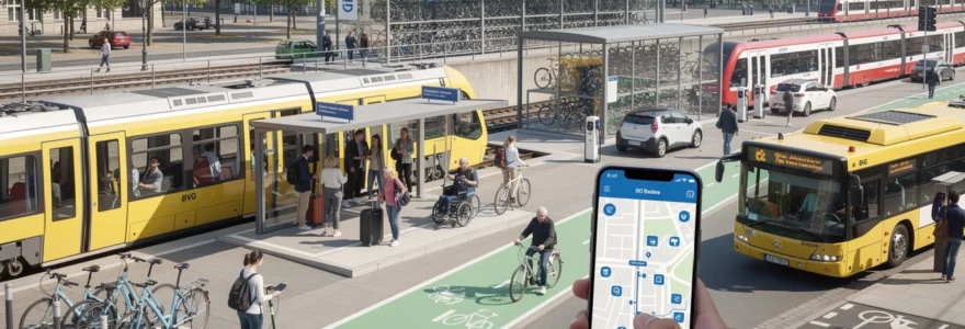
Jelbi mobility app: unified platform for BVG, deutsche bahn, and micromobility services
The Jelbi mobility app, launched by BVG in 2019, embodies this ambition to unify urban transport in Berlin. Through a single interface, you can plan journeys that combine U-Bahn, S-Bahn, trams, buses, bike-sharing, e-scooters, and car-sharing offers from multiple providers. Rather than switching between different apps for each leg of your trip, Jelbi lets you search, book, and pay for multimodal routes in one place. For residents who frequently mix public transport with micromobility, this consolidation significantly reduces friction.
Jelbi also serves as a testbed for future mobility services, including on-demand shuttles and, potentially, autonomous vehicles as the technology matures. By integrating Deutsche Bahn’s regional and S-Bahn services alongside BVG operations, the app reflects a holistic view of mobility rather than a narrow focus on one operator. In practical terms, if you are heading from a residential area in Pankow to a co-working space in Neukölln, Jelbi can propose a combination of tram, U-Bahn, and a final e-scooter hop, complete with live departure times and price estimates. This kind of door-to-door planning is central to reducing dependence on private cars.
VBB fahrcard subscription models: monthly abo and annual season ticket options
For frequent travellers, the VBB Fahrcard is a contactless smartcard that stores various subscription products, most notably the monthly Abo and annual season tickets. Instead of buying individual paper tickets, you simply carry your card and validate it when required, with fare inspectors using handheld readers to check its validity. The monthly Abo typically renews automatically, spreading the cost of commuting and often offering discounts compared with buying single or day tickets. Many employers in Berlin also participate in corporate schemes that subsidise staff Abos, further encouraging public transport usage.
Annual season tickets, loaded onto the Fahrcard, provide even greater savings and are particularly attractive if you know you will be using transportation in Berlin every day. These passes often come with additional perks, such as the ability to take along a companion or children during off-peak times, which can make a tangible difference for families. From a policy standpoint, shifting riders from occasional pay-as-you-go travel to stable subscriptions helps BVG and VBB forecast revenue and plan capacity more effectively. For users, it turns mobility into a predictable utility, much like your monthly internet bill.
Single-journey tickets versus day passes: cost analysis for tourists and commuters
Choosing between single-journey tickets and day passes is one of the most common dilemmas for visitors navigating transportation in Berlin. Single tickets in the AB zone allow travel for up to 120 minutes in one direction, with unlimited transfers between modes, and are ideal if you plan only one or two trips. However, if you foresee multiple hops—perhaps from your hotel to a museum, then to a different district for dinner, and back again—a day pass (Tageskarte) usually offers better value. As a rule of thumb, three or more standard rides in a day will often justify the cost of a day ticket.
For commuters, a stack of single tickets or even daily passes quickly becomes uneconomical compared with weekly or monthly products. The cost savings of moving to a week, month, or year ticket can be substantial, often cutting per-trip costs by half or more. When planning your budget, ask yourself: “How many days per week will I actually ride?” If the answer is four or five, stepping up to a longer-term pass is almost always the smarter choice, in both financial and psychological terms—you remove the small daily decision of whether a ticket is “worth it” and simply travel when you need to.
Berlin WelcomeCard: transport and museum access combined discount scheme
The Berlin WelcomeCard is tailored for tourists who want a simple way to combine transportation in Berlin with sightseeing and cultural experiences. Available for durations ranging from 48 hours to six days and in AB or ABC variants, it includes unlimited travel on public transport plus discounts at hundreds of attractions, tours, and museums. For visitors planning to explore major sites like Museum Island, the Berlin TV Tower, or boat tours on the Spree, the bundled savings can quickly outweigh the upfront cost of the card.
In addition to convenience, the WelcomeCard serves as a strategic tool for the city, channelling tourists toward sustainable urban mobility rather than taxis or rental cars. Think of it as a “mobility and culture passport” that lowers the barrier to using buses and trains by making them the default choice from day one of your trip. When evaluating whether the card suits your itinerary, list the sights you want to visit and compare the sum of standard ticket prices plus individual transport fares against the WelcomeCard package. In many cases, especially for first-time visitors who enjoy spontaneous exploring, the all-in-one simplicity is itself worth the investment.
Cycling infrastructure and velomobility development initiatives
Cycling has become a cornerstone of sustainable transportation in Berlin, with the city steadily enhancing its bike infrastructure to match rising demand. An estimated 18–20% of all trips in Berlin are now made by bicycle, and the local government has set ambitious targets to increase this modal share further. As climate goals and congestion concerns sharpen, velomobility—mobility based on bicycles and related vehicles—offers a low-cost, space-efficient alternative to cars. But what makes cycling in Berlin increasingly attractive compared with other European capitals?
The answer lies in a combination of protected lanes, expanding express routes, bike-sharing options, and secure parking facilities at key nodes. Together, these elements help remove the main barriers that discourage people from cycling: safety concerns, lack of continuity in routes, and fear of theft. By treating cycling as a fully fledged mode of urban transport rather than a leisure activity, Berlin is gradually redesigning its streetscape to accommodate two wheels as comfortably as four.
Protected cycle lanes: friedrichstrasse’s car-free zone and separated track expansion
One of the most visible symbols of Berlin’s cycling shift is the transformation of Friedrichstrasse, a major central artery that has been partially converted into a car-free zone. In this stretch, wide, protected cycle lanes and generous pedestrian areas replace what were once car lanes, sending a clear signal about future priorities for transportation in Berlin. Early evaluations show increased foot traffic, more comfortable cycling, and a calmer urban atmosphere, all of which support local businesses and quality of life. The experiment has also sparked debate: should more central streets follow a similar model?
Beyond flagship projects, the city has been systematically expanding separated bike tracks on busy corridors, often using physical barriers or raised curbs to shield cyclists from motor traffic. These protected cycle lanes function like “expressways” for bikes, making journeys faster and less stressful, especially for less experienced riders. The approach mirrors how the U-Bahn provides dedicated right-of-way for trains: by giving bikes their own safe space, Berlin encourages a broader demographic—including children, seniors, and casual riders—to choose cycling for everyday mobility.
Bike-sharing schemes: nextbike, call a bike, and dockless operator regulations
Bike-sharing has become an integral part of urban mobility in Berlin, filling gaps where personal bike ownership is less convenient. Systems like Nextbike and Deutsche Bahn’s Call a Bike allow users to pick up cycles at docking stations or via app-based locking mechanisms. These schemes are particularly useful for visitors or occasional riders who prefer not to worry about storage or maintenance. For Berliners commuting multimodally, shared bikes often handle the last kilometre from a station to home or office.
The city has also seen waves of dockless bike operators, which initially led to cluttered pavements before tighter regulations were introduced. Today, Berlin works with providers to establish designated parking areas and clearer rules for fleet size and distribution, striking a balance between flexibility and public space management. From the user’s perspective, the choice of multiple operators means more availability and competitive pricing. If you already rely on public transport, adding bike-sharing to your toolkit can feel like adding a versatile “gear” to your personal mobility system, giving you more control over door-to-door travel times.
Radschnellwege: express cycle highway routes connecting suburbs to city centre
To support longer bike commutes, Berlin and the surrounding state of Brandenburg are developing Radschnellwege, or express cycle highways. These are wide, largely uninterrupted routes designed to connect outer suburbs with the city centre, often following railway lines or former industrial corridors. The goal is to make 10–15 kilometre bike trips as viable and comfortable as shorter inner-city rides, offering a sustainable alternative to car or regional rail commuting. In practice, this means fewer intersections, priority at crossings, and high-quality surfaces that allow for steady speeds.
Several Radschnellweg corridors are in planning or early construction stages, linking areas such as Spandau, Tegel, and Adlershof to central Berlin. For daily riders, these express routes can cut travel times significantly while providing a more predictable journey than traffic-dependent car travel. If you live outside the S-Bahn Ring and have hesitated to cycle due to fragmented infrastructure, these cycle highways could change your calculus. Think of them as the cycling equivalent of the S-Bahn Ring and radial lines, giving structure and cohesion to the broader velomobility network.
Secure bicycle parking: fahrradstationen at hauptbahnhof and alexanderplatz hubs
Secure parking is a crucial yet often overlooked component of cycling infrastructure. In Berlin, Fahrradstationen—large, guarded bicycle parking facilities—at major hubs like Hauptbahnhof and Alexanderplatz help address fears of theft and vandalism. These stations typically offer hundreds of covered spaces, maintenance services, and sometimes rental bikes, turning them into comprehensive bike service centres. For commuters arriving by regional or S-Bahn trains, being able to leave a bike safely at the station makes intermodal journeys much more appealing.
Beyond these flagship facilities, Berlin has been increasing the number of on-street bike racks, lockable boxes, and residential parking solutions. Some new housing developments now include secure indoor bike rooms as standard, further integrating bicycles into everyday life. As with car parking, the availability of reliable bike parking directly influences whether people choose to ride in the first place. By treating bike security as seriously as vehicle garages, the city reinforces the idea that cycling is not just a hobby, but a core component of transportation in Berlin.
Micromobility solutions: e-scooters, car-sharing, and last-mile connectivity
In recent years, micromobility has emerged as a flexible bridge between public transport and destinations that lie just beyond convenient walking distance. E-scooters, free-floating car-sharing, and compact electric vehicles are now familiar sights on Berlin’s streets, offering new ways to cover the “last mile” of your journey. These services thrive in dense districts where parking is scarce and short trips are frequent. Yet they also raise new questions about regulation, safety, and integration into existing transport systems.
For transportation in Berlin, the challenge is to harness micromobility’s benefits—speed, convenience, and reduced emissions—while minimising downsides like pavement clutter or unsafe riding behaviour. This balance requires coordinated policies, designated parking zones, and data-sharing agreements between operators and the city. When managed well, micromobility can function like a set of “mobility spices”, adding just the right flavour of flexibility to an already rich public transport base.
E-scooter operators: tier, lime, and voi deployment across designated parking zones
E-scooters burst onto Berlin’s streets in 2019, led by operators such as Tier, Lime, and Voi. These lightweight, app-activated vehicles are particularly popular for short urban hops of one to three kilometres, often connecting S- or U-Bahn stations with workplaces or nightlife areas. Users simply unlock a scooter with their smartphone, ride to their destination, and park within a designated zone displayed in the app. Pricing usually combines a fixed unlock fee with a per-minute rate, making scooters most economical for quick trips rather than long rentals.
To address concerns about safety and public space, Berlin has implemented rules that restrict scooter speeds, limit operation to certain areas, and define no-parking or slow-speed zones. Designated parking areas, sometimes marked on the street or collected in virtual “corrals” in apps, help reduce clutter on pavements and at busy junctions. If you are considering e-scooters as part of your mobility mix, it is worth familiarising yourself with local rules—riding on pavements, for example, is prohibited and subject to fines. When used responsibly and in conjunction with public transport, e-scooters can significantly shrink perceived distances in the city.
Station-based car-sharing: SHARE NOW and MILES free-floating vehicle networks
Car-sharing in Berlin offers a middle ground between full car ownership and exclusive reliance on public transport. Services like SHARE NOW and MILES operate large fleets of free-floating cars that can be picked up and dropped off within defined business areas across the city. Instead of paying for a vehicle 24/7, you pay by the minute or kilometre, with fuel, insurance, and parking in public spaces typically included. This model is particularly attractive for occasional trips that are cumbersome by transit, such as bulk shopping or visits to friends in less well-connected suburbs.
Some providers also operate station-based or hybrid schemes, where cars must be returned to specific locations, often near major transit hubs. This creates natural integration points between transportation in Berlin’s public network and flexible car access. From an urban planning perspective, widespread car-sharing can help reduce private car ownership, freeing up street space for cycling infrastructure, greenery, or wider pavements. For individuals, a useful question to ask is: “How often do I really need a car?” If the answer is “once or twice a week,” car-sharing may be more economical and sustainable than owning a private vehicle.
Electric vehicle charging points: integration with EnBW and vattenfall infrastructure
As Berlin pushes toward climate neutrality, electric vehicles (EVs) play an expanding role in its mobility mix. Public charging infrastructure, supported by energy providers such as EnBW and Vattenfall, is being rolled out across the city, from residential districts to commercial zones and key transit hubs. These charging points cater both to private EV owners and to shared fleets, including e-car-sharing vehicles and, increasingly, electric taxis. Many are integrated into parking bays along streets or in multi-storey car parks, making charging a routine part of parking rather than a special trip.
For users of EV-based car-sharing, the charging network largely remains in the background—operators manage battery levels and route vehicles to chargers as needed. However, if you own an EV or plan to do so, checking the spatial distribution and capacity of public charging points becomes essential for planning daily life. In the broader context of transportation in Berlin, the development of this infrastructure supports the city’s goal of phasing out fossil-fuel buses and private combustion-engine cars, aligning everyday mobility choices with long-term environmental objectives.
Accessibility standards and universal design in berlin’s transport system
Accessibility and universal design are central pillars of Berlin’s transport strategy, ensuring that mobility options work for everyone—regardless of age, disability, or income. This commitment is visible in the steady retrofitting of older infrastructure and the stringent requirements placed on new projects. Low-floor vehicles, tactile guidance systems, lifts, and audible announcements are no longer optional extras but standard features. For many residents, these measures determine whether they can participate fully in city life.
On the U-Bahn and S-Bahn, an increasing share of stations now offers step-free access via lifts or ramps, with clear signage indicating accessible routes. Buses and trams feature boarding ramps and dedicated spaces for wheelchairs, prams, and mobility aids. Real-time passenger information systems display not only delays but also disruptions affecting lifts or escalators, helping users plan alternative routes where necessary. By designing transportation in Berlin around the needs of its most vulnerable users, the city ultimately creates a more comfortable experience for everyone—after all, luggage, shopping bags, and tired legs benefit from universal design just as much as wheelchairs do.
Real-time journey planning: VBB apps, google maps integration, and disruption management
Real-time journey planning has become an indispensable part of using transportation in Berlin, especially in a network as complex and interconnected as this one. Official VBB and BVG apps provide live departure times, route options, and notifications about service changes across U-Bahn, S-Bahn, trams, buses, and regional trains. These tools allow you to adapt on the fly when disruptions occur, such as signal failures, construction work, or weather-related delays. Instead of waiting passively on a platform, you can quickly evaluate alternative routes, including walking or cycling segments.
Popular third-party platforms like Google Maps and other navigation apps integrate VBB data, making it easy for visitors to access reliable directions without learning a new interface. This interoperability means that whether you prefer the official app or a familiar global service, you still benefit from up-to-date information. During major planned works, such as U-Bahn line closures for upgrades, apps highlight replacement bus services and suggest modified routes. In a sprawling city like Berlin, the ability to re-route in real time is more than a convenience—it is a key ingredient in keeping the entire mobility system resilient and user-friendly.


