The world’s most celebrated cities contain layers that conventional tourism rarely penetrates. Beneath the surface of guided tours and carefully curated attractions lies a parallel urban realm—one characterised by derelict infrastructure, forgotten architectural movements, and subterranean networks that reveal cities as living, evolving organisms rather than static postcards. This alternative approach to discovering urban environments requires different skills, perspectives, and ethical considerations than mainstream sightseeing. For those willing to look beyond the obvious, cities transform from collections of landmarks into complex texts written in concrete, steel, and decay.
The motivations driving this unconventional exploration extend far beyond simple curiosity or the thrill of trespassing. Urban explorers engage with spaces that embody historical transitions, architectural experimentation, and social memory in ways that manicured heritage sites cannot. These practitioners—whether photographers, psychogeographers, or architecture enthusiasts—seek authentic encounters with urban fabric, finding beauty in deterioration and significance in abandonment. Their documentation serves purposes ranging from artistic expression to historical preservation, creating archives of structures and spaces that might otherwise vanish without record.
Psychogeography and dérive: navigating cities through situationist urban exploration techniques
The Situationist International movement of the 1950s and 1960s developed methodologies for understanding cities that remain remarkably relevant to contemporary urban exploration. Psychogeography—the study of how geographical environments affect emotions and behaviour—provides a theoretical framework for moving through urban spaces in ways that challenge conventional navigation. Rather than following tourist maps or efficiency-optimised routes, psychogeographic exploration prioritises emotional resonance and unexpected discovery.
Guy debord’s theory of the dérive applied to contemporary city walking
The dérive, or “drift”, represents a deliberate abandonment of typical motivations for movement through urban space. Guy Debord conceptualised this practice as a means of experiencing cities beyond their utilitarian functions, allowing the psychogeographical contours of neighbourhoods to guide direction rather than predetermined destinations. Contemporary practitioners adapt this approach by disabling navigation applications, following architectural features or material traces, and permitting chance encounters to shape their routes. A dérive through Manchester’s Northern Quarter might begin with following cast-iron drainage covers from different eras, leading from Victorian industrial sites through 1960s brutalist interventions to contemporary redevelopments—a journey that reveals temporal layering invisible to purposeful navigation.
Mapping emotional topographies in london’s forgotten industrial quarters
London’s deindustrialised zones offer particularly rich terrain for psychogeographic investigation. The Lea Valley, stretching from Hackney Wick through Tottenham to Enfield, contains remnants of manufacturing infrastructure gradually being absorbed into residential and commercial redevelopment. Mapping these transitions requires attention to affective atmospheres—the emotional qualities that linger in spaces even after their original functions have ceased. A walk along the River Lea reveals shifts between post-industrial melancholy, creative appropriation, and sanitised regeneration within metres, creating emotional topographies more complex than any official planning document acknowledges.
Unplanned routes through berlin’s hinterhöfe and courtyards
Berlin’s distinctive courtyard architecture—the Hinterhöfe system developed during rapid 19th-century urbanisation—creates semi-public spaces that most visitors never encounter. These interconnected interior courtyards were designed to maximise density whilst providing light and air to rear buildings, resulting in labyrinthine networks invisible from street level. Psychogeographic exploration of these spaces in districts like Kreuzberg and Prenzlauer Berg reveals how historical working-class housing has been transformed through gentrification, with some courtyards retaining industrial character whilst others have become curated cultural spaces. The practice of moving through these zones without predetermined routes exposes the tension between preservation and transformation that characterises contemporary Berlin.
Recording ambient soundscapes in manchester’s Post-Industrial canal networks
Psychogeography extends beyond visual observation to encompass the acoustic dimensions of urban environments. Manchester’s extensive canal system, developed during the Industrial Revolution to transport goods between factories and ports, now provides corridors through the city where ambient sound differs dramatically from street-level noise. Recording expeditions along
the Rochdale, Ashton and Bridgewater canals might focus on capturing the subtle echoes of footfalls under brick bridges, the sudden roar of passing trains above, or the muffled resonance of water against warehouse foundations. By comparing recordings from different stretches and at different times of day, explorers can map how sound reflects changing land use—from dormant mills and empty loading bays to converted lofts and new cultural venues. For many urban explorers, these ambient soundscapes become as important as photographs, offering an alternative archive of post-industrial transition that can be revisited, remixed, and shared.
Accessing derelict infrastructure: legal frameworks and urban exploration ethics
Moving from drift and ambience to doors, fences, and property lines inevitably raises questions of legality and responsibility. Urban exploration may romanticise forgotten places, but it also operates in a world of trespass laws, liability concerns, and genuine safety hazards. Understanding how different legal systems treat access to abandoned infrastructure—and developing an ethical framework that goes beyond “not getting caught”—is essential if you want to explore cities beyond typical tourist attractions without causing harm to yourself, others, or the sites you visit.
Trespass laws across european jurisdictions: belgium’s abandoned sites vs uk restrictions
In Europe, the legal status of entering abandoned buildings varies markedly between jurisdictions. In England and Wales, simple trespass on non-residential land is usually a civil matter rather than a criminal offence, but it becomes criminal if you ignore explicit orders to leave, damage property, or enter certain protected infrastructure such as railways or military facilities. Scotland, with its tradition of broader access rights to land, still protects buildings and curtilage more strictly than open countryside. The UK’s relatively tight regulation around critical infrastructure means that many iconic “urbex” targets—substations, tunnels, transport depots—sit behind firm legal red lines.
Belgium offers a contrasting case study often cited in urban exploration forums. The country has a high concentration of abandoned industrial sites, sanatoria, and châteaux, some of which have become semi-tolerated destinations for photographers and explorers. While trespass remains unlawful, enforcement can be inconsistent, and some municipalities quietly acknowledge that low-impact visitation brings soft cultural capital and, occasionally, heritage interest. This does not confer a right of access, but it illustrates how informal local norms sometimes diverge from national legal frameworks. Serious practitioners research cadastral records, planning notices, and local regulations rather than relying on hearsay, recognising that “everyone goes there” is not a legal defence.
Photographing detroit’s michigan central station without commercial exploitation
Detroit’s Michigan Central Station—long emblematic of American deindustrialisation—highlights the tension between documentation and exploitation. For years, access to the derelict station was informally tolerated, leading to a proliferation of atmospheric images that helped cement Detroit’s global reputation for “ruin porn”. As redevelopment plans accelerated and ownership shifted, informal entry became more tightly controlled, and ethical questions about representing the site grew sharper. Using images of neglected spaces purely as aesthetic backdrops, divorced from the economic and social histories that produced them, risks turning complex urban narratives into consumable spectacle.
Responsible photographers navigating sites like Michigan Central Station adopt clear guidelines. They avoid staging fashion shoots or brand content without permission, resist selling prints or licensing images commercially unless rights and revenue-sharing are negotiated, and provide contextual captions that foreground labour history, displacement, and ongoing community initiatives. You might, for instance, pair images of peeling plasterwork with references to local preservation campaigns or redevelopment plans rather than framing them as anonymous decay. Treat the camera not as a tool for extraction, but as a medium for critical storytelling and, where possible, for amplifying local voices.
Safety protocols for exploring abandoned soviet-era installations in eastern europe
Abandoned Soviet-era installations across Eastern Europe—radar bases, missile silos, industrial combines—offer some of the most visually compelling urban exploration environments, but they also carry specific risks. Structural degradation is often advanced, with corroded steel, spalling concrete, and unmarked shafts or basements. In former industrial and military zones, contamination by asbestos, oils, heavy metals, or residual radiation can be a non-obvious hazard; the absence of warning signs does not equate to safety. Unlike managed “dark tourism” sites such as Chernobyl’s most-visited routes, these locations rarely benefit from professional monitoring or remediation.
Experienced explorers mitigate these risks with protocols that resemble a pared-down version of industrial safety practice. This typically includes wearing respirators with P3 filters in dusty interiors, using helmets and gloves, and carrying at least two independent light sources with spare batteries. People plan exit routes in advance, log coordinates with trusted contacts, and adopt a strict “no solo exploration” rule in remote zones. If you are travelling across borders to visit Soviet-era sites, it is worth cross-referencing online trip reports with official environmental data where available, and recognising that some installations may still fall under security legislation even decades after decommissioning.
Collaborative relationships with urban conservation trusts and heritage bodies
As urban exploration moves from fringe hobby to widely shared visual culture, heritage organisations have begun to see serious explorers as potential allies rather than nuisances. In many cities, conservation trusts are understaffed and struggle to monitor the condition of dispersed, semi-abandoned assets. Carefully documented site visits—photographs, measured sketches, written observations—can provide early warning of structural failure, vandalism, or theft. In return, formal collaborations can open doors to legal access, guided inspections, and opportunities to exhibit work or contribute to interpretation materials.
Building these relationships requires a shift in mindset. Instead of treating locations as secret trophies, you approach them as shared heritage resources. This might mean agreeing not to publish precise coordinates, submitting image sets to archives under Creative Commons licences, or participating in supervised survey days for at-risk structures. Heritage bodies, for their part, can acknowledge the value of “bottom-up” documentation practices that capture buildings in their raw, pre-restoration state. When trust develops, urban explorers often find themselves invited into spaces that remain off-limits to mainstream tourism but are explored in a way that aligns with long-term preservation goals.
Underground networks: storm drains, catacombs, and subterranean architecture
Below the curated surfaces of cities lies a parallel world of tunnels, culverts, and carved chambers that has long fascinated urban explorers. These subterranean environments compress history and infrastructure into close quarters: medieval quarries repurposed as ossuaries, Victorian sewers running beneath glass office towers, Cold War bunkers hidden behind innocuous service doors. For many, descending into these spaces feels less like tourism and more like slipping through a crack in the everyday city, entering a backstage where the logistical underpinnings of urban life are suddenly exposed.
Paris catacombs beyond the official tourist route: accessing restricted ossuary chambers
The Paris Catacombs illustrate the tension between regulated access and clandestine exploration perhaps more sharply than any other site. The official ossuary route receives hundreds of thousands of visitors each year, guided along a controlled, lit path through a small fraction of the tunnel network. Beyond locked gates, however, stretches more than 200 kilometres of former limestone quarries, wartime shelters, and informal art spaces frequented by cataphiles. For decades, these unofficial visitors have mapped, decorated, and occasionally inhabited sections of the network, creating a subculture with its own norms, rituals, and codes of conduct.
From a legal perspective, unauthorised entry into non-public quarry sections is prohibited and routinely policed by a dedicated underground unit of the Paris police. Ethically, the question becomes more complex: does the existence of a rich, community-maintained subterranean culture justify breaking formal rules? Many contemporary commentators argue for a middle path, in which the creative and exploratory energy of cataphile culture is acknowledged while advocating for expanded legal access through managed tours, cultural events, or artist residencies. For visitors tempted by the allure of “secret” Paris, the safest and most responsible choice is to seek out sanctioned experiences rather than risking unstable ceilings, flooding, or arrest in restricted chambers.
Melbourne’s victorian-era stormwater system and drainage infrastructure
In Melbourne, urban exploration has long gravitated towards the extensive Victorian-era stormwater drains that coil beneath the city’s inner suburbs. Unlike catacombs filled with human remains, these systems are utilitarian spaces—brick-lined ovoid tunnels, junction chambers, and culverts that channel runoff towards the Yarra River and Port Phillip Bay. Their appeal lies in the engineering elegance of nineteenth-century brickwork, the acoustic qualities of water echoing along curved surfaces, and the eerie sense of walking through a hidden river that surfaces only during storms. For some explorers, traversing these drains is akin to reading an inverted map of the city, following contours and catchments rather than streets and tram lines.
However, storm drain exploration poses specific and serious hazards that go beyond those of abandoned buildings. Flash flooding can occur with little warning, especially in cities experiencing more intense rainfall events due to climate change. Toxic gases may accumulate in poorly ventilated sections, and the smooth, algae-coated floors of drains become treacherous when wet. Local exploring communities therefore tend to impose strict self-regulation: no entry during or shortly after rain, constant monitoring of weather radar, and a culture of mentoring newcomers in risk assessment. If you are drawn to such infrastructure, ask yourself whether the thrill justifies the compounded risks—and whether photographing a brick arch is worth gambling with rapidly rising water levels.
Budapest’s labyrinth beneath castle hill and medieval cave network
Beneath Buda’s Castle Hill lies a naturally formed cave system that has been expanded and repurposed over centuries as cellars, wartime shelters, and, more recently, tourist attractions. The so-called “Labyrinth” accessible to visitors today represents only a curated portion of this subterranean topology, complete with interpretive displays and atmospheric lighting. Yet archival records and specialist surveys indicate that a more extensive honeycomb of passages, wells, and interlinked basements continues beyond the official boundaries, connecting to town houses, churches, and historic institutions on the hill above. This layered underworld provides a vivid three-dimensional cross-section of Budapest’s urban evolution.
For explorers interested in subterranean architecture, Castle Hill raises key questions about the difference between adventure tourism and genuine discovery. Is navigating the official Labyrinth with a ticket in hand any less “authentic” than slipping into unlit side tunnels via unsecured cellars? Or can we see the curated route as one path along a broader continuum of engagement with the underground city? In practice, Hungarian authorities have tightened controls on informal access in response to collapses and unregulated commercial events. The more constructive avenue for deep engagement may lie in joining speleological societies, participating in licensed surveys, or supporting conservation projects that balance public curiosity with the structural stability of centuries-old rock and masonry.
Brutalist architecture trail mapping: identifying lesser-known concrete landmarks
Not all urban exploration involves decay or disuse; sometimes it is about tracing overlooked architectural lineages through still-functioning cityscapes. Brutalism—often caricatured as monolithic concrete and looming shadows—has undergone a significant reassessment in recent years, with enthusiasts mapping trails that link major icons to lesser-known local landmarks. Treating a city as an open-air archive of post-war experimentation allows you to move beyond familiar postcard views and into estates, office complexes, and civic centres that rarely feature in standard tourist itineraries but reveal how societies imagined their futures in concrete.
Robin hood gardens documentation before demolition: smithson architecture legacy
London’s Robin Hood Gardens estate, designed by Alison and Peter Smithson and completed in the early 1970s, became a focal point for debates about Brutalism’s cultural value. Long stigmatised in popular discourse as an example of failed social housing, the estate nevertheless attracted architects, photographers, and urban theorists who saw in its “streets in the sky” an ambitious attempt to reconfigure urban living. As demolition loomed in the late 2010s, a surge of documentation projects emerged: measured drawings by architecture schools, oral histories with residents, 3D scans, and extensive photographic series capturing everything from concrete textures to improvised gardens on access decks.
For urban explorers, Robin Hood Gardens exemplified a different kind of “abandoned” space—one that was socially and politically abandoned before it was physically erased. Rather than sneaking into boarded-up flats, many chose to engage publicly: attending open days, collaborating with resident groups, or contributing images and reflections to online archives. If you are mapping brutalist trails today, you inevitably navigate the absence of Robin Hood Gardens, tracing its ghost through fragments in museums and the altered skyline of Poplar. The lesson is clear: documentation is most powerful when it happens before structures slip into outright dereliction, when lived experience and daily routines can still be recorded alongside architectural form.
Belgrade’s genex tower and yugoslav socialist modernism
Belgrade’s Western City Gate, more commonly known as Genex Tower, stands as one of the most striking examples of Yugoslav socialist modernism. Comprising twin concrete towers linked by a skybridge and a circular restaurant pod, it once symbolised technological optimism and a gateway to a modern capital. Today, with one tower largely residential and the other largely vacant, the complex straddles the line between everyday utility and monumentality. Many visitors see only a distant silhouette from the highway; urban explorers, by contrast, map approaches through surrounding housing blocks, service roads, and neglected green spaces to experience the structure at multiple scales.
Engaging critically with Genex Tower means situating it within the broader landscape of post-socialist transition. What does it mean for a building designed as a corporate headquarters and showcase object to stand half-empty amid shifting ownership and redevelopment schemes? When you photograph its raw concrete and panoramic views, are you documenting resilience, obsolescence, or both? Local guides and architecture groups increasingly offer contextual tours that blend rooftop vistas with discussions of energy efficiency, maintenance challenges, and heritage listing debates. Using these frameworks, explorers can turn a brutalist icon from mere backdrop into a lens on regional history and contested futures.
Boston city hall plaza and paul rudolph’s government service center
Across the Atlantic, Boston offers its own cluster of contentious brutalist landmarks concentrated around the Government Center area. Boston City Hall, with its inverted ziggurat form and deeply recessed windows, anchors a windswept plaza often criticised for its lack of human scale. Nearby, Paul Rudolph’s Government Service Center—partially realised from a larger masterplan—adds even more aggressively sculpted concrete volumes to the ensemble. For decades, these structures have been lightning rods in debates about “ugly” government architecture, security theatre, and the legacy of mid-century urban renewal projects that razed older neighbourhoods.
Exploring this district as an urban explorer rather than a casual passerby involves looking closely at circulation patterns, thresholds, and how people actually inhabit the spaces. You might trace the routes of protest marches across the plaza, document informal uses like skateboarders or food trucks, or compare archival photographs with current security modifications and landscaping interventions. Rather than seeking physical abandonment, the focus shifts to underused or psychologically “abandoned” zones where design intentions and lived experience diverge. In mapping such sites, you join ongoing efforts by architects, planners, and activists to reimagine how these buildings might be adapted or softened without erasing their radical formal qualities.
Documenting vernacular architecture in transitional urban zones
Beyond headline-grabbing ruins and iconic brutalist complexes lies a vast field of vernacular architecture: workshops behind terraced houses, ad hoc rooftop extensions, informal kiosks, and hybrid live-work units. These structures rarely appear in guidebooks or heritage registers, yet they shape the everyday experience of transitional neighbourhoods undergoing gentrification, deindustrialisation, or demographic shifts. For urban explorers, paying attention to vernacular forms is akin to reading the city’s marginalia—scribbled notes and corrections at the edges of official plans.
Documenting such spaces demands a slower, more conversational form of exploration. Instead of slipping anonymously into empty factories, you might talk with repair-shop owners about how they adapted former stables into garages, or observe how migrant communities repurpose ground-floor units into cultural hubs and grocery stores. Photographs can capture hand-painted signage, improvised shading devices, or the layering of different construction techniques over decades. Yet ethical practice is crucial: ask permission before photographing private premises, avoid exoticising poverty or precarity, and consider whether publishing precise locations might accelerate speculative investment and displacement.
In many cities, grassroots heritage campaigns now recognise the importance of these modest architectures as repositories of craft knowledge and community memory. Urban explorers contribute by assembling visual atlases that trace, for example, the gradual replacement of corrugated sheds with glass-fronted studios, or the survival of certain building types despite zoning pressure. The question we must keep asking is: who benefits from our attention? Ideally, documentation should support local claims to space—strengthening arguments for conservation, adaptive reuse, or social infrastructure—rather than simply feeding a global appetite for images of “authentic” city life.
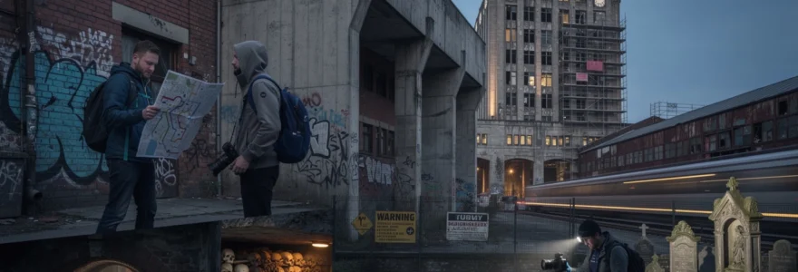
Night photography techniques for capturing urban liminal spaces
Many of the most evocative urban liminal spaces—railway sidings, canal towpaths, empty plazas, and cemeteries—reveal different personalities after dark. Sodium-vapour lamps carve out pools of orange light, LED signage spills colour across facades, and long-shutter exposures transform passing vehicles into ribbons of motion. For photographers, night-time urban exploration becomes both a technical and conceptual challenge: how do you render the atmosphere of partial abandonment and intermittent activity without losing detail to darkness or digital artefacts?
Long-exposure settings for abandoned railway stations and goods yards
Abandoned or semi-active railway stations and goods yards are particularly rewarding subjects for long-exposure night photography. Their repetitive structural elements—tracks, gantries, canopies—provide strong leading lines, while intermittent train movements or distant city glow introduce dynamic light sources. As a starting point, many photographers work in manual mode with apertures between f/5.6 and f/11, shutter speeds from 10 to 30 seconds, and ISO settings kept as low as practical (100–400) to minimise noise. A sturdy tripod and remote shutter release or timer are essential to avoid camera shake during long exposures.
Compositionally, consider whether you want to emphasise stillness or motion. A completely abandoned yard might benefit from static, high-detail captures that reveal rust, weeds, and weathered textures under ambient light. In contrast, a semi-operational line passing in the background can be rendered as smooth light trails that suggest the persistence of networked mobility beyond the dereliction in the foreground. Always maintain a safe distance from active tracks, obey railway by-laws, and be aware that trespass on rail property is often treated as a serious criminal offence. No image is worth compromising your personal safety or disrupting operations.
Light painting techniques in glasgow’s victorian necropolis
Cemeteries like Glasgow’s Victorian Necropolis, with their dense assemblages of monuments, obelisks, and mausolea, provide richly textured environments for creative night photography—when accessed legally during permitted hours or special events. Light painting involves using handheld torches, LED wands, or even small flashes to selectively illuminate parts of a scene during a long exposure. By “scribbling” light across gravestones or tracing the outlines of iron railings, you can sculpt depth and contrast in ways that ambient street lighting alone cannot achieve.
To keep results subtle rather than theatrical, many practitioners use low-output, diffused light sources and move continuously during exposure to avoid hotspots. Working at around ISO 200–400 with 20–30 second exposures gives enough time to paint multiple elements within a single frame. Ethically, it is important to treat such sites with respect: avoid stepping on graves, refrain from gimmicky poses that trivialise memorial landscapes, and be mindful of nearby residents who may interpret unusual nocturnal activity as suspicious. Think of light painting less as a special effect and more as a way to gently reveal inscriptions, carvings, and sculptural forms that daylight often flattens.
Minimising digital noise in low-light industrial ruin photography
Low-light photography in industrial ruins presents a familiar technical enemy: digital noise. Pushing ISO levels to compensate for dim interiors or night-time exteriors quickly introduces grainy artefacts, particularly in shadow areas and uniform colour fields such as skies or concrete walls. One of the most effective ways to control this is simply to embrace slower workflows: use a tripod, keep ISO low, and extend shutter speeds as needed, checking histograms to avoid crushing shadows or blowing out highlight sources like bare bulbs and windows.
In-camera noise reduction can help for JPEG shooters, but for maximum control it is often better to shoot RAW and apply targeted noise reduction in post-processing software. Here, the analogy of conservation work is useful: you are carefully cleaning an image, not sandblasting it. Apply global luminance noise reduction sparingly, then mask in stronger adjustments only where necessary, preserving edge sharpness and fine detail like rust textures or peeling paint. Finally, remember that a certain level of grain can actually reinforce the mood of urban exploration photography, echoing the material roughness and ambiguity of the spaces themselves. The goal is not clinical perfection, but a balance between technical clarity and atmospheric depth that does justice to the fragile, liminal worlds you are documenting.


