Scotland’s Highland region presents one of Europe’s most formidable landscapes for remote travel, where ancient geological forces have carved deep glens, towering peaks, and isolated peninsulas that challenge even the most experienced adventurers. The sheer scale and ruggedness of this terrain, spanning over 25,000 square kilometres, creates unique obstacles for those seeking to explore its pristine wilderness areas. From the weather-beaten summits of the Cairngorms to the remote sea lochs of the northwest coast, accessing these remarkable landscapes requires careful planning, specialised equipment, and an understanding of the complex logistical challenges that define Highland travel.
The infrastructure limitations, communication blackouts, and unpredictable weather patterns that characterise the Scottish Highlands transform what might appear as straightforward journeys on maps into complex expeditions requiring mountaineering-level preparation. These challenges have shaped the region’s character for centuries, creating pockets of wilderness that remain as untouched today as they were during the clan era.
Geographic challenges and terrain analysis of scotland’s highland regions
The Scottish Highlands encompass a geological wonderland where Precambrian rocks dating back over 1.2 billion years create some of Britain’s most challenging terrain. This ancient landscape, sculpted by successive ice ages, presents a complex mosaic of mountain ranges, deep valleys, and isolated plateaus that create natural barriers to conventional travel routes. The region’s topography varies dramatically from the rolling hills of the southern Highlands to the knife-edge ridges and corries of the Torridon mountains, each presenting distinct challenges for remote access.
Weather patterns across the Highlands can change within minutes, with mountain summits experiencing conditions vastly different from valley floors. The western regions receive over 3,000mm of annual rainfall in some areas, while eastern slopes may experience significantly drier conditions due to the rain shadow effect. These microclimates create unpredictable conditions where visibility can drop to mere metres on mountain peaks while valleys remain clear, fundamentally altering the accessibility of remote areas.
Munro accessibility assessment: ben nevis to cairn gorm traverse routes
The 282 Munros scattered across the Scottish Highlands present varying degrees of accessibility challenges, with some requiring multi-day expeditions through trackless wilderness. Ben Nevis, Britain’s highest peak at 1,345 metres, attracts over 150,000 annual visitors, yet its proximity to Fort William makes it one of the more accessible summits. In contrast, remote Munros like A’ Mhaighdean in the Fisherfield Forest require 12-kilometre approaches through pathless terrain where navigation skills become critical for safe passage.
The Cairngorms plateau, covering over 100 square kilometres above 1,000 metres elevation, creates unique challenges due to its vast, featureless terrain where whiteout conditions can disorientate even experienced mountaineers. Compass navigation becomes essential when GPS signals fail or batteries drain in sub-zero temperatures that can persist for months across these high-altitude areas.
Glen coe and torridon weather pattern impact on remote access
Glen Coe’s reputation as Scotland’s most dramatic valley extends beyond its visual impact to encompass some of the country’s most challenging weather conditions. The valley’s orientation creates a natural funnel for Atlantic weather systems, generating wind speeds that regularly exceed 100 mph on exposed ridges. These conditions can transform straightforward ridge walks into life-threatening expeditions within hours, particularly during winter months when avalanche risk adds another layer of complexity.
The Torridon region experiences similarly extreme weather variations, where the proximity to the Atlantic Ocean creates rapid temperature fluctuations and sudden onset of severe conditions. Weather windows for safe passage through remote areas often last only hours rather than days, requiring flexible itineraries and contingency planning that extends expedition timelines significantly.
Single track road infrastructure limitations from fort william to mallaig
The West Highland Line corridor from Fort William to Mallaig exemplifies the infrastructure challenges facing Highland travel, where single-track roads with passing places create bottlenecks that can delay journeys by hours during peak seasons. This 46-mile route, while scenically spectacular, demonstrates how geographical constraints limit road development in mountainous terrain where engineering costs
remain prohibitively high and environmental protections restrict large-scale widening projects. For drivers, this means allowing generous time buffers, understanding how to use passing places correctly, and accepting that journey times in the Scottish Highlands often bear little resemblance to equivalent distances in lowland or urban areas. In poor weather, especially during winter storms, sections of this road can become temporarily impassable due to flooding, fallen trees, or coastal spray, further complicating access to remote communities along the route.
Isle of skye bridge dependency and alternative ferry route analysis
The Skye Bridge has fundamentally reshaped access to the Isle of Skye, turning what was once a ferry-dependent journey into a year-round, road-based connection. This dependency on a single fixed link, however, creates vulnerability: accidents, high winds, or essential maintenance can cause delays or closures, temporarily isolating the island for road traffic. For travellers planning remote hiking or mountaineering itineraries on Skye, these potential disruptions must be factored into both arrival and departure planning.
Alternative ferry routes provide valuable redundancy but operate on limited schedules. Services from Mallaig to Armadale, and from Glenelg to Kylerhea during the summer season, offer scenic crossings but are highly weather-dependent and can be suspended in strong winds or heavy swell. When planning remote travel in the Scottish Highlands, particularly if you have fixed accommodation or guiding bookings, it is wise to monitor CalMac advisories, build in at least half a day of flexibility, and avoid scheduling key connections immediately before international flights or onward rail journeys.
Transportation infrastructure and remote connectivity solutions
Despite its reputation for wildness, the Scottish Highlands are supported by a surprisingly intricate web of transport infrastructure that threads through glens, across sea lochs, and along exposed coastal fringes. Understanding how rail, ferry, and road networks interact is crucial if you want to reach the most remote corners without unnecessary delay or risk. While the system is robust by rural European standards, it remains highly sensitive to weather events, seasonal demand, and maintenance closures, which means that real-time information and contingency planning are key components of successful Highland travel.
In recent years, regional authorities and national agencies have invested in resilience measures designed to maintain access to remote communities even under adverse conditions. These include landslide mitigation on key trunk roads, upgraded harbour facilities for lifeline ferries, and timetabling changes on rail lines to better connect with ferry departures. Nevertheless, travellers venturing into the Highlands should think of the transport network as a living system rather than a fixed timetable, adjusting their expectations in line with the realities of a sparsely populated, weather-exposed region.
West highland line railway services: kyle of lochalsh terminal operations
The West Highland Line, often cited as one of the world’s most scenic rail journeys, forms a critical backbone for access to remote areas including Mallaig and, via connections, the Isle of Skye and the Small Isles. A related branch line from Inverness to Kyle of Lochalsh terminates within sight of the Skye Bridge, making Kyle an important multimodal node for travellers aiming to combine rail, bus, and foot travel in the northwest Highlands. For those without a car, this line can be the difference between a feasible remote itinerary and one that is simply impractical.
Terminal operations at Kyle of Lochalsh have adapted to the demands of both tourism and local communities. Coordinated bus links to Portree and other Skye settlements, luggage facilities, and weather-protected waiting areas all contribute to smoother transitions between modes of transport. However, services are relatively infrequent, particularly in winter, so you should plan around fixed train times rather than assuming spontaneous travel. When heading into remote areas beyond Kyle, building your hiking or camping schedule around the last return train can be as important as watching the weather forecast.
Calmac ferry network integration with outer hebrides access points
The Caledonian MacBrayne (CalMac) ferry network is the lifeline for many island communities and an essential component of remote travel planning in the Scottish Highlands. Routes from Ullapool to Stornoway, Uig to Tarbert and Lochmaddy, and Oban to Castlebay and Lochboisdale form primary access points to the Outer Hebrides, each with its own operational nuances. For example, the long crossing from Ullapool is more exposed to North Atlantic weather systems, while shorter crossings from Skye often run multiple times per day in peak season but may still be cancelled at short notice when conditions deteriorate.
Integration between ferry schedules, local buses, and mainland rail services has improved in the last decade, but gaps remain, particularly outside summer. If your remote travel plans involve multi-stage journeys, such as connecting from the West Highland Line to an evening ferry and then driving to an isolated croft or bothy, it is prudent to plan conservative buffers between each leg. Booking ferries well in advance is essential in high season, not only for vehicles but also, on popular routes, for foot passengers. In remote contexts, missing a ferry can mean losing an entire day, which can cascade through an itinerary built around narrow weather windows or limited accommodation options.
A82 and A87 road condition monitoring systems
The A82 and A87 are two of the most important arterial roads for reaching key Highland regions, including Glencoe, Fort William, Loch Ness, and the Isle of Skye. Both routes traverse areas prone to landslides, snow accumulation, and ice formation, making real-time condition monitoring vital for both local authorities and travellers. Transport Scotland employs a combination of roadside sensors, CCTV, and patrols to track surface temperatures, precipitation, and traffic flow, feeding into roadside variable message signs and online updates.
For those planning remote journeys, especially in winter or shoulder seasons, accessing this data before departure can significantly reduce risk. Websites and apps that aggregate live traffic information, weather warnings, and incident reports help you decide whether to delay a journey, reroute via an alternative corridor, or adjust your end destination for the day. Treat these roads as dynamic environments rather than static corridors: a section that was clear in the morning can be closed by afternoon due to a sudden snow squall or a rockfall triggered by heavy rain, and diversions can add hours to a day’s travel in the Highlands.
Highland council transport partnership strategic planning
Strategic planning for transport in the Scottish Highlands is coordinated through partnerships between Highland Council, Transport Scotland, and regional bodies such as HiTrans (the Highlands and Islands Transport Partnership). Their long-term goal is to balance the needs of local residents, tourism, and environmental protection while preserving the unique character of the landscape. This involves difficult decisions about where to invest in road widening, where to introduce or expand public transport services, and where to limit growth to protect fragile ecosystems.
For remote travellers, the outcomes of this planning are felt in the availability of seasonal bus routes to trailheads, the presence of park-and-ride schemes in congested glens, and the gradual improvement of parking and toilet facilities in high-pressure locations like Glen Coe and the Fairy Pools on Skye. These measures not only support visitor experience but also reduce the impact of growing footfall on communities that may only have a few hundred residents. Keeping an eye on consultation documents and route changes can give you early insight into future access improvements or restrictions in the areas you most want to explore.
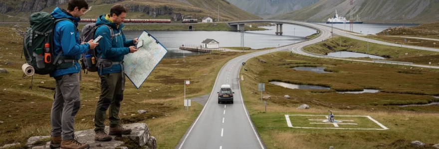
Emergency helicopter landing site requirements in remote glens
In many remote glens and mountain regions of the Scottish Highlands, helicopter evacuation is the only feasible means of rapid medical assistance. As a result, identifying and maintaining suitable landing zones forms a quiet but critical part of emergency planning. These sites must offer relatively flat ground, minimal obstructions, and adequate approach paths, all while being close enough to popular trails, bothies, and climbing routes to reduce response times when every minute counts.
Mountain rescue teams and local land managers often pre-survey and record potential landing sites using GPS coordinates and detailed notes on seasonal conditions, such as snow cover or bog formation. For serious expeditions in the Cairngorms or Northwest Highlands, understanding that rescue crews may need to move casualties to these pre-identified zones can influence your own route planning. Choosing camp locations near known clearings, avoiding deep ravines when possible, and carrying equipment suitable for short carries or drags can make a critical difference if you or a member of your party requires air evacuation.
Digital communication barriers in highland wilderness areas
Despite ongoing investment in rural broadband and 4G coverage, large swathes of the Scottish Highlands remain digital black spots where mobile signals are intermittent or non-existent. Remote glens, deep corries, and sea lochs flanked by steep mountainsides can block line-of-sight to cell towers, leaving you without connectivity just when you might most need it. For remote travellers, this means that familiar assumptions from urban life – such as being able to check a live forecast, call a taxi, or share your location – simply do not apply.
Relying solely on smartphones for navigation and safety in these conditions is risky. Battery drain is accelerated by cold temperatures and constant signal searching, and apps that depend on live data can become useless as soon as you leave major roads or settlements. As a result, experienced Highland travellers adopt a layered approach: pre-downloading offline maps, carrying independent navigation tools, and treating any mobile reception as a bonus rather than a guarantee. Awareness of these communication barriers is the first step towards building a resilient, self-reliant travel strategy in the Highlands.
Essential navigation technology for cairngorms and northwest highlands
Navigating the Cairngorms and the remote ranges of the Northwest Highlands requires more than a casual glance at a smartphone map. Vast plateaus, complex ridge systems, and featureless moorland can feel like open seas, where tiny errors in direction compound into major deviations over several kilometres. To travel safely and confidently, especially in poor visibility, you need to combine traditional skills with modern tools, selecting equipment that will still function when weather, temperature, and terrain push everything to its limits.
Think of your navigation setup as a redundancy system: if one element fails, others should still keep you on course. A printed topographic map, a reliable baseplate compass, a GPS device or smartphone with offline mapping, and a power bank or spare batteries each play a role in this layered approach. Before stepping into the wilderness, it is worth asking yourself: if my primary device failed right now, could I still reach safety using what I have in my pack and the skills in my head?
Ordnance survey explorer map series 1:25,000 coverage gaps
The Ordnance Survey (OS) Explorer series at 1:25,000 scale is the gold standard for detailed navigation in the Scottish Highlands, offering contour lines, land cover, paths, and key features at a resolution suitable for precise route-finding. However, coverage is divided across multiple sheets, and travellers sometimes overlook the need to carry more than one map when routes traverse large plateaus or cross regional boundaries. In the Cairngorms, for instance, longer traverses can easily move between three or more Explorer sheets in a single day.
Certain remote corners of the Northwest Highlands highlight another subtle challenge: while OS coverage is comprehensive in theory, some paths, new hydro tracks, and informal routes can lag behind on printed editions. This does not mean these areas are unmapped, but rather that you must be prepared for discrepancies between what you see on the paper and what you encounter underfoot. Treat the map as a framework rather than a script, cross-checking with satellite imagery or digital mapping tools during the planning phase at home, when you still have reliable connectivity.
GPS signal reliability in ben mor assynt and schiehallion regions
GPS technology has transformed how many of us navigate, but it is not infallible in the Highland environment. In mountainous regions such as Ben Mor Assynt and Schiehallion, steep-sided corries, narrow glens, and dense cloud cover can degrade signal quality or temporarily reduce the number of satellites visible to your device. While complete signal loss is rare in open ground, positional drift or lag can mislead you, particularly if you are relying on a breadcrumb trail or smartphone app without cross-checking against a physical map.
Practical mitigation strategies include using GPS as a confirmation tool rather than your sole reference. Marking key waypoints – such as bealachs, river crossings, and escape routes – in advance can help you reorient rapidly if visibility drops. Equally important is managing power: cold temperatures on Cairngorms summits in winter can drain batteries in hours, so insulating devices, limiting screen-on time, and carrying backup power are essential habits. Think of GPS as a highly capable but occasionally temperamental companion: invaluable when used wisely, but dangerous if trusted blindly.
Mountain rescue team coordination technology requirements
Scottish Mountain Rescue teams operate at the intersection of traditional hillcraft and cutting-edge technology. Their coordination systems must function reliably across vast, sparsely populated areas, often in severe weather and total darkness. To achieve this, teams combine VHF radios, satellite communication devices, digital mapping software, and increasingly, drone reconnaissance where conditions allow. Centralised incident control points track team locations in real time, overlaying them on topographic maps to ensure safe deployment and efficient search coverage.
For remote travellers, understanding how these systems work has two main benefits. First, it clarifies why providing accurate information during an emergency call – such as grid references, recent route choices, and group size – can dramatically speed up response. Second, it highlights the value of carrying compatible tools yourself: a simple handheld radio tuned to emergency channels is not usually necessary, but the ability to relay a precise grid reference from an OS map or GPS device is. Effective coordination depends on a common language of location, and learning to express your position clearly can make you a far easier party to assist if trouble arises.
What3words integration for remote bothies and shelters
In recent years, the location-based service what3words has gained traction as a complementary tool for identifying precise positions in the Scottish Highlands. By dividing the globe into 3m x 3m squares, each assigned a unique three-word code, the system offers an intuitive way for non-specialists to communicate exact locations without resorting to grid references. Many mountain rescue teams and emergency services in Scotland now accept what3words references as part of their standard call-handling procedures.
Remote bothies, shelters, and popular wild camping spots are increasingly being catalogued with both grid references and what3words addresses, shared on walking forums and guide websites. While this can be helpful, especially for newcomers, it is important not to let convenience erode core navigation skills. You should treat what3words as a backup or supplementary layer, not a replacement for understanding maps and terrain. Before a trip, saving both the grid references and three-word addresses of key refuges can provide multiple avenues for communication in an emergency, particularly if you are guiding less experienced companions.
Seasonal access restrictions and weather-dependent route planning
Seasonality shapes almost every aspect of remote travel in the Scottish Highlands. Winter brings snow-covered passes, frozen lochans, and avalanche risk on lee slopes; spring can see swollen rivers and lingering snow patches; summer introduces midges but also longer daylight hours; and autumn often delivers powerful Atlantic storms. Each season shifts the balance of what routes are viable, what equipment is necessary, and how much time you should allow for even modest distances.
Access restrictions add another layer of complexity. During the stag stalking season, typically from late summer into autumn, certain estates request that walkers avoid specific glens or follow indicated stalkers’ paths to minimise disturbance. In some areas, forest operations or hydroelectric construction can temporarily close tracks or change access points. Responsible travellers check estate websites or local signage, adapting routes to respect land management needs. Building weather-dependent flexibility into your plans – identifying low-level alternatives, out-and-back options, and safe escape routes – allows you to respond intelligently when forecasts deteriorate or on-the-ground conditions differ from expectations.
Emergency preparedness protocols for isolated highland expeditions
Venturing into the more isolated corners of the Scottish Highlands demands a mindset closer to that of an expedition than a casual weekend walk. Once you leave roadheads and popular Munro circuits behind, self-sufficiency becomes the primary safety net. This begins with robust pre-trip planning: leaving a clear route plan with a trusted contact, including expected timings, alternative routes, and check-in points, and agreeing on what to do if you fail to make contact by a set time.
On the hill, carrying an appropriate emergency kit is non-negotiable. At a minimum, this should include a group shelter or bivvy bag, spare insulating layers, a headtorch with fresh batteries, a basic first aid kit, high-energy food reserves, and tools for fire-lighting. An emergency beacon, such as a Personal Locator Beacon (PLB) or satellite communicator, can provide a vital last line of defence in areas without mobile coverage, especially for solo travellers or small groups far from established paths. Used responsibly, these devices complement rather than replace risk-aware decision-making.
Finally, effective emergency preparedness in the Highlands is as much about judgement as equipment. Knowing when to turn back, how to assess river crossings, and when to shorten a route in response to changing weather are all skills honed over time. By combining respect for the environment with realistic self-assessment, you transform the challenge of remote Highland travel from a potential liability into a profound source of adventure and connection with one of Europe’s last great wilderness landscapes.


