Cape Town’s transport landscape tells a story of deep contrasts, where world-class infrastructure coexists alongside informal networks that serve millions daily. The city’s mobility options range from modern bus rapid transit systems to ubiquitous minibus taxis, each revealing something about the socioeconomic divides that characterize South Africa’s legislative capital. Understanding how to navigate Cape Town requires more than simply knowing which bus to catch—it demands awareness of how geography, investment, and historical inequalities have shaped vastly different transport experiences across neighbourhoods. For visitors and residents alike, getting from point A to point B can be straightforward in affluent suburbs yet remarkably challenging in peripheral townships, where the majority of the population actually lives.
The disparities in transport accessibility reflect broader patterns of urban development that continue to shape daily life. Whether you’re relying on ride-hailing apps, climbing aboard a shared taxi, or using the formal bus network, your experience will differ dramatically depending on which part of the city you’re travelling through. These differences aren’t merely inconvenient—they fundamentally impact economic opportunities, quality of life, and social integration across communities separated by just a few kilometres.
Myciti bus rapid transit system: routes, fare cards and coverage zones
The MyCiTi system represents Cape Town’s most ambitious attempt at creating integrated, reliable public transport. Launched in 2010, this bus rapid transit network operates along dedicated lanes, allowing buses to bypass traffic congestion that plagues the city’s major arteries. The system uses distinctive blue-and-white articulated buses that feel remarkably modern compared to traditional public transport options, offering air conditioning, accessible boarding, and real-time information displays.
Understanding MyCiTi route networks from city centre to table view
The MyCiTi network radiates from the city centre along several key corridors, with the Table View route being particularly popular among commuters and tourists. This coastal corridor connects central Cape Town with the northern suburbs along routes that showcase both the city’s stunning ocean vistas and its suburban sprawl. Buses run at regular intervals during peak periods, typically every 10-15 minutes, though service frequency drops considerably during off-peak hours and weekends.
The network’s design prioritises tourist routes and middle-class commuter corridors, creating excellent connectivity along the Atlantic Seaboard and into established northern suburbs. However, this focus leaves significant gaps in service coverage, particularly in areas where transport needs are most acute. Routes generally operate from early morning until late evening, with some services extending past midnight on weekends to accommodate nightlife in popular entertainment districts.
Acquiring and topping up myconnect cards at station kiosks
Access to the MyCiTi system requires a myconnect card, the cashless payment method that has replaced traditional ticketing. These reloadable smart cards can be purchased at station kiosks, selected retailers, and customer service centres throughout the network. The initial card purchase requires a refundable deposit, after which users can load credit for individual journeys or purchase period passes for unlimited travel within specified zones.
Fare calculation depends on distance travelled and zones crossed, with the system automatically deducting the correct amount when you tap your card at both boarding and alighting. Top-up facilities are reasonably accessible within the network’s coverage area, though limitations emerge in peripheral regions where MyCiTi infrastructure remains sparse. The cashless system, while efficient, can present barriers for unbanked populations who may find it challenging to maintain and reload cards regularly.
Service limitations in township areas: khayelitsha and gugulethu access
The most glaring limitation of the MyCiTi network becomes apparent when examining its coverage—or lack thereof—in Cape Town’s largest residential areas. Khayelitsha, home to an estimated 400,000 residents, and Gugulethu, with approximately 300,000 inhabitants, have minimal MyCiTi integration despite representing massive population centres with substantial transport demand. This absence isn’t accidental but reflects decades of underinvestment in township infrastructure.
Plans to extend the network into these areas have faced repeated delays, funding challenges, and political complications. The result is that millions of township residents continue relying on informal minibus taxis and overcrowded Golden Arrow buses
during peak hours. For anyone living in these townships, using MyCiTi as a primary mode of transport is often impractical, requiring multiple transfers or long walks to reach the nearest station corridor. In effect, the system works best for those already living in relatively well-served suburbs, while reinforcing the existing divide between the formal city and the townships on its periphery.
For visitors, this means you can move quite efficiently between the City Bowl, Table View and the Atlantic Seaboard, but you cannot rely on MyCiTi alone to reach places like Khayelitsha, Gugulethu or Nyanga. If you’re planning to volunteer, visit friends, or explore cultural tours in these areas, you’ll almost always need to combine modes: a MyCiTi bus to a hub, then a taxi or e-hailing service beyond. This lack of direct integration not only adds time and cost, it also underlines how different the daily commute looks when you cross Cape Town’s invisible socioeconomic borders.
Airport transfer options via MyCiTi A01 civic centre route
One of the MyCiTi network’s strongest features is the dedicated airport route, the A01 bus between Cape Town International Airport and the Civic Centre station in the CBD. Operating from early morning to late at night, this route offers a predictable, fixed-fare alternative to taxis and ride-hailing services, which can be significantly more expensive during peak times. The buses have luggage racks, level boarding, and clear signage, making them especially user-friendly if you’re arriving in Cape Town for the first time.
The A01 airport bus connects directly to other key MyCiTi routes at Civic Centre, allowing relatively seamless transfers to areas such as Gardens, Sea Point, Waterfront, and Table View. If you’re staying in the City Bowl or along the Atlantic Seaboard, this can be the most cost-effective and reliable way to travel from the airport. However, if your accommodation is in townships like Khayelitsha or on the Cape Flats, the airport bus only gets you halfway; you’ll need a taxi, Uber, or minibus taxi for the final leg of your journey. This “last-mile” challenge reflects once again how the same piece of infrastructure can feel convenient for some residents and incomplete for others.
When deciding between the airport bus and private transport, consider your arrival time and luggage. Late-night arrivals may find it safer and more comfortable to use a reputable taxi or ride-hailing service, particularly if onward connections are required. During the day, though, the A01 is a strong option for budget-conscious travellers who want a straightforward route into the city while avoiding the unpredictability of traffic and surge pricing.
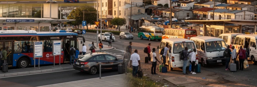
Minibus taxi networks and informal transport infrastructure
If MyCiTi represents the formal face of Cape Town transport, the minibus taxi network is its beating heart. These 15-seater vehicles, often operating outside rigid timetables and dedicated lanes, carry the majority of working-class commuters across the metropolitan area. Routes lace together townships, industrial zones and the CBD in a dense web that has evolved organically over decades, long before current planning frameworks existed. For many residents of Khayelitsha, Mitchells Plain, Gugulethu and Nyanga, minibus taxis are not just an option—they are the only practical way to get to work, school or healthcare facilities.
Yet this informal system is as complex as it is indispensable. There are few published route maps, signage is minimal, and local knowledge is crucial to understanding where to stand, what hand signals to use, and how fares are negotiated. For a newcomer, it can feel like trying to interpret a language with no written grammar. Still, once you understand the basics, you begin to see how this seemingly chaotic system fills the massive gaps left by formal transport in Cape Town’s low-income areas.
Golden arrow bus services versus taxi rank operations
Golden Arrow Bus Services, a long-established operator in Cape Town, provides scheduled bus routes that crisscross the metro, often serving the same townships and suburbs as minibus taxis. These buses typically follow fixed timetables and designated stops, offering a more regulated alternative to the flexible but informal taxi network. Fares are usually competitive with minibus taxis, though journey times can be longer due to frequent stops and adherence to defined routes. For many commuters, Golden Arrow buses offer a sense of predictability, even if they lack the speed and door-to-door convenience of taxis.
Taxi ranks, by contrast, operate as dynamic hubs where routes start and end based on passenger demand rather than strict scheduling. In places like the Cape Town Station deck, Bellville, Mitchells Plain Town Centre and Wynberg, ranks are crowded, noisy and highly organised behind the scenes, with marshals directing vehicles and ensuring that taxis leave only when full. This demand-driven model can mean short waiting times during peak hours but frustrating delays during quieter periods. From a visitor’s perspective, ranks can feel intimidating, yet they are central to everyday life for millions of Capetonians who depend on this network to navigate long distances between the city’s fragmented residential and economic zones.
Navigating taxi routes between mitchells plain and cape town CBD
The corridor between Mitchells Plain and the Cape Town CBD is one of the busiest commuter routes in the city, illustrating how crucial minibus taxis are for connecting the Cape Flats to economic opportunities. Taxis depart from Mitchells Plain Town Centre, Beacon Valley and other local nodes, heading towards town via key arteries like the N2 freeway. During morning and evening peaks, vehicles depart in quick succession, sometimes every few minutes, to meet the enormous demand. For commuters, this can mean relatively short waiting times but long, congested journeys, especially when traffic bottlenecks build up near the city entrances.
If you’re not familiar with the system, knowing where to board and how to signal for your destination is essential. Most taxis display hand-painted signs or cardboard placards in the front window indicating “Town”, “M Plain”, “Wynberg” or other major endpoints. Passengers usually pay by passing money forward to the driver, with one person in the back acting as an informal “cashier” to calculate change. For an outsider, this ritual might feel confusing at first, but you quickly see how this shared responsibility keeps costs low and journeys moving. However, language barriers, unfamiliarity with local customs and concerns about safety mean that many foreign visitors still hesitate to use these taxis, defaulting instead to Uber or MyCiTi where possible.
Safety protocols for foreign visitors using communal taxis
For foreign visitors, the question is often not whether minibus taxis are efficient—they are—but whether they are safe enough to use. The reality is nuanced. While millions of trips happen daily without incident, there are legitimate concerns about driving standards, overcrowding, and occasional taxi-related crime. If you decide to experience this cornerstone of Cape Town transport, doing so with a local guide or friend who understands the system is by far the safest approach. This is especially true in townships and on longer routes, where it can be harder to quickly change plans if you feel uncomfortable.
Practically, you should avoid travelling with visible valuables, keep your phone out of sight, and sit closer to the middle or front of the vehicle if space allows. Night-time trips in unfamiliar areas are best avoided unless you are with someone who knows the route well. Think of it as entering a busy, fast-moving marketplace: it can be vibrant and eye-opening, but you need to stay aware of your surroundings and know when to opt out. For most tourists, sticking to minibus taxis on well-known daylight routes—or joining a guided township tour that uses them—is a balanced way to experience this part of Cape Town’s mobility culture without taking unnecessary risks.
Peak hour congestion at bellville and claremont taxi ranks
Major taxi ranks like Bellville and Claremont offer a vivid lens on how Cape Town’s transport system strains under peak-hour pressure. Bellville, a key interchange for commuters from the northern suburbs and outlying townships, becomes intensely congested between 6–9 a.m. and 4–7 p.m. Taxis jostle for space, informal traders line the sidewalks, and streams of passengers weave between vehicles in search of the right route. For many workers travelling from areas like Delft, Kraaifontein or Mfuleni, Bellville is a compulsory transfer point, adding both time and stress to already long commutes.
Claremont, serving southern suburbs and parts of the Cape Flats, faces similar surges, though on a smaller scale. Here, commuters from areas like Lotus River, Grassy Park and Retreat connect to formal bus and rail services or continue by taxi to workplaces and schools. During these peak windows, taxi ranks can feel overwhelming, especially if you’re new to the city: noise levels are high, space is cramped, and pedestrian safety can be a real concern. Understanding this congestion helps explain why many middle-class residents prefer private cars or ride-hailing, while working-class commuters endure crowded conditions as a daily norm.
Ride-hailing applications: uber and bolt service disparities across suburbs
Ride-hailing platforms such as Uber and Bolt have transformed how people move around Cape Town, particularly in the City Bowl, Atlantic Seaboard and affluent southern suburbs. With just a few taps on your phone, you can request a vehicle, track its arrival, and pay cashless—an appealing alternative to navigating unfamiliar taxi ranks or waiting for buses. But like other transport modes, the availability and cost of these services vary sharply between neighbourhoods. Where wealth and tourism concentrate, supply is high and response times are short; in more marginalised townships, drivers may be scarce and cancellations more frequent.
This uneven access mirrors broader digital and economic divides. In high-income areas with strong smartphone penetration and reliable mobile data, e-hailing has become almost a default mode for night-time outings, airport transfers and cross-city trips. On the Cape Flats, where residents often share devices and face data costs that eat into tight budgets, using ride-hailing can be less straightforward. The result is a mobility ecosystem where those who already enjoy better public transport also benefit more from private tech-based solutions, reinforcing the contrast between Cape Town’s “two cities”.
Premium pricing in atlantic seaboard: camps bay to clifton routes
Nowhere is this disparity more visible than along the Atlantic Seaboard, particularly between Camps Bay and Clifton. These beachfront suburbs attract high tourist volumes and feature some of the most expensive real estate in South Africa, and ride-hailing prices often reflect that profile. Dynamic pricing—or “surge”—tends to kick in on sunny weekends, during sunset hours, and after major events when demand spikes. A short hop from Camps Bay to the V&A Waterfront can cost more than a much longer journey from the City Bowl to the southern suburbs at off-peak times.
For visitors, this premium pricing can come as a surprise, especially if you assume that all parts of Cape Town are equally affordable to navigate. Planning ahead helps: you can check estimated fares before accepting a ride and, when possible, travel just outside the peak sunset or nightlife windows to avoid the steepest charges. It’s a bit like booking a beachfront hotel versus an inland guesthouse—you pay more for convenience and scenery. While MyCiTi does serve parts of the Atlantic Seaboard, many people still opt for Uber or Bolt here due to door-to-door convenience, even if it means higher costs compared to other suburbs.
Driver availability challenges in cape flats townships
On the Cape Flats, the equation flips: ride-hailing fares may be lower on average, but driver availability is a persistent challenge. Areas like Khayelitsha, Gugulethu and Nyanga often experience longer waiting times, higher cancellation rates, or drivers refusing trips perceived as risky, especially at night. Safety concerns—both real and perceived—shape where drivers are willing to operate, how long they wait for passengers, and whether they accept cash payments. As a result, residents in these neighbourhoods cannot rely on ride-hailing as consistently as those in the City Bowl or Sea Point.
If you’re staying or visiting in these areas, it’s wise to arrange transport in advance where possible. Coordinating with a trusted local driver, using daytime travel windows, and sharing live trip details with someone you know can all enhance safety. You might notice that drivers prefer pick-ups and drop-offs on better-lit main roads rather than deep inside residential backstreets, which again reveals how infrastructure and perceived risk shape service patterns. For many township residents, ride-hailing remains an occasional supplement to minibus taxis rather than a primary mode of transport.
Metre taxi services from V&A waterfront and long street pickup points
Traditional metre taxis still play a role in Cape Town’s mobility mix, particularly at established tourist hotspots like the V&A Waterfront and along Long Street. These vehicles usually wait at designated ranks outside malls, hotels and nightlife districts, offering a visible, immediate alternative to app-based services. Fares are either calculated by meter or agreed upfront, so it’s important to confirm the price before departing, especially if you’re unfamiliar with typical rates. Compared to ride-hailing, metre taxis can sometimes be more expensive, but they provide certainty if your mobile data fails or your app struggles to find a nearby driver.
Metre taxis are subject to licensing regulations and operate within relatively formalised frameworks, though service quality can vary between operators. For visitors concerned about using minibus taxis at night but hesitant about surge pricing on Uber, a rank-based taxi from the Waterfront or Long Street can feel like a middle ground. As always, basic precautions apply: choose vehicles that appear roadworthy, confirm the driver’s name and company, and avoid unmarked cars claiming to be “taxi” services without clear identification. This segment of the industry has had to adapt to the rise of e-hailing, yet in key tourist zones it remains a familiar and trusted option.
Car rental mobility between affluent southern suburbs and peripheral townships
Hiring a car is another common way to get around Cape Town, particularly if you plan to explore the wider region, from Constantia’s wine estates to the Cape Peninsula. For residents of affluent southern suburbs such as Newlands, Rondebosch and Constantia, car ownership or rental is often a default expectation, supported by good road infrastructure, secure parking and relatively low-density environments. Having your own vehicle allows you to bypass some of the delays and limitations of public transport, making it easier to juggle work, school runs and leisure activities scattered across the metropolitan area.
However, the benefits of car rental are not evenly distributed across the city’s geography. Driving into or through peripheral townships can mean encountering narrower roads, informal trading along pavements, fewer formal parking options and, in some cases, higher risks of petty crime. Many visitors therefore choose to access these areas via guided tours or with local hosts who understand the safest routes and times of travel. From a planning perspective, this creates a stark contrast: residents in wealthier suburbs experience the city as a network optimised for private cars, while township residents face longer, multi-leg journeys by taxi and bus to reach the same destinations.
If you do rent a car, think carefully about where you’ll be parking overnight, how comfortable you feel driving after dark, and whether your itinerary regularly crosses between affluent and low-income districts. It’s not that certain areas should be avoided altogether, but that a realistic appreciation of infrastructure and security conditions helps you make informed choices. In many ways, having a car in Cape Town is like holding a master key: it unlocks easy access to beaches, mountains and wine regions, while also highlighting how many people must navigate the same distances without that key.
Contrast in transport accessibility: constantia versus langa
The contrast between Constantia, one of Cape Town’s most affluent suburbs, and Langa, one of its oldest townships, encapsulates the city’s transport inequalities. In Constantia, leafy streets connect seamlessly to wide, well-maintained roads linking residents to the M3 highway and major shopping and employment nodes. Most households own at least one car, and additional options such as Uber, Bolt and private shuttle services are readily available. Public transport exists but is often a backup rather than a lifeline.
In Langa, just a few kilometres away, the picture is very different. Many residents rely primarily on minibus taxis and Golden Arrow buses, with far fewer owning private vehicles. While Langa has some proximity advantages—located close to the N2 and not far from the CBD—the quality, reliability and safety of available transport options lag behind wealthier suburbs. Walking is common, yet pedestrian infrastructure is inconsistent, and rail services, where they once played a strong role, have become unreliable on certain lines. These contrasting realities shape not only how long it takes people to get around Cape Town, but also how they perceive their connection to the broader city.
Infrastructure investment gaps between northern suburbs and cape flats
Looking more broadly, infrastructure investment patterns reveal a clear gap between the relatively well-served northern suburbs and the sprawling Cape Flats. Areas such as Durbanville, Bellville and Edgemead benefit from upgraded intersections, consistent road maintenance, and visible traffic enforcement. They also enjoy stronger integration with formal bus and e-hailing services. By contrast, large parts of the Cape Flats still contend with aging road surfaces, limited traffic calming in residential zones, and underdeveloped transport interchanges.
This imbalance is not accidental; it reflects decades of spatial planning that prioritised certain corridors over others. When new bus lanes, railway upgrades or highway expansions are proposed, political debates frequently arise over whether resources should first address high-demand township routes or consolidate existing middle-class commuter infrastructure. The result is often a patchwork of improvements that leaves some communities feeling perennially “next in line”. For someone commuting daily from a northern suburb, delays may be an occasional annoyance. For someone from the Cape Flats, they can translate into chronic lateness, reduced job prospects and a deeper sense of exclusion from Cape Town’s economic core.
Commute duration analysis: observatory to khayelitsha daily travel times
Consider, for example, the journey between Observatory, an inner-city neighbourhood with good access to main roads and MyCiTi services, and Khayelitsha on the far eastern edge of the metro. By car outside peak hours, this trip can take roughly 30–40 minutes along the N2. But for someone relying on public transport, the commute time stretches significantly. A typical itinerary might involve a taxi or bus from Khayelitsha to a major interchange, a transfer to another taxi or train, and then a final leg into Observatory—each step adding potential delays.
During peak periods, total travel times of 60–90 minutes one way are common, especially when congestion near city entrances or at taxi ranks is factored in. That’s the equivalent of commuting from a different town, even though the straight-line distance is modest. For a worker who has to clock in by 8 a.m., this means leaving home before 6 a.m., with little room for unexpected disruptions. Meanwhile, someone living in Observatory but working in the CBD might cover their entire journey in 15–20 minutes by bus, bike or car. This stark contrast in commute durations highlights how geography and mode choice intersect to reinforce socioeconomic divides.
Pedestrian safety standards in sea point versus nyanga
Pedestrian safety is another area where Cape Town’s contrasts are visible at street level. In Sea Point, a popular coastal suburb, wide pavements, clear signage, zebra crossings and traffic lights create a relatively pedestrian-friendly environment. The Sea Point Promenade, in particular, offers a dedicated space for walking, jogging and cycling, separate from vehicular traffic. Street lighting is generally good, and a visible security presence—both private and public—contributes to a sense of safety for people moving around on foot, even after dark.
In Nyanga, one of the city’s most under-resourced townships, conditions are often the reverse. Narrow or non-existent pavements, informal trading spilling into the roadway, and high traffic volumes make walking inherently riskier. Crossings may be poorly marked, and drivers sometimes treat residential streets like through-routes, increasing the danger for children and elderly pedestrians. Night-time walking is particularly precarious due to patchy lighting and security concerns. It’s a bit like comparing a well-marked hiking trail with a rough, unsigned path: the physical act of walking may be the same, but the level of risk and stress is vastly different.
Street lighting and road maintenance quality differentials
Street lighting and road maintenance form the invisible backbone of any city’s transport experience, and Cape Town is no exception. In wealthier areas such as the City Bowl, Constantia and Tygervalley, streetlights are more consistently functional, potholes are repaired relatively quickly, and road markings remain visible. These seemingly small details add up to safer night-time driving, clearer navigation and fewer vehicle damages—benefits that residents may take for granted until they travel elsewhere in the city.
On the Cape Flats and in some townships, the picture is uneven. Broken or dim streetlights can leave long stretches of road in semi-darkness, complicating both driving and walking after dusk. Potholes and uneven surfaces are more common, forcing minibus taxi drivers to swerve or slow abruptly, contributing to longer journey times and increased accident risk. For cyclists and pedestrians, these conditions raise the everyday cost of mobility, whether through injuries, vehicle repairs or simply the decision to avoid certain routes at night. When we talk about “transport inequality” in Cape Town, these micro-level differences in basic infrastructure are as important as high-profile projects like MyCiTi or rail upgrades.
Navigating socioeconomic boundaries: transport between city bowl and outlying areas
Travelling between the City Bowl and Cape Town’s outlying areas often means crossing profound socioeconomic boundaries in the space of a single trip. Within a 30–40 minute radius of the CBD, you can move from high-rise offices and trendy cafés to informal settlements and industrial zones. Each of these spaces is stitched together by a mix of rail lines, highways, bus corridors and taxi routes, yet the quality and safety of those connections vary sharply. For many residents, daily mobility is not just about distance and time but about navigating these invisible borders in ways that feel safe and predictable.
Visitors sometimes treat the City Bowl as a self-contained bubble, using Uber or MyCiTi to move between Table Mountain, the V&A Waterfront and the Atlantic Seaboard while rarely venturing beyond. But if you’re working, volunteering or visiting friends in areas like Mitchells Plain, Philippi or Bonteheuwel, your transport decisions take on a different weight. Questions of which route to take, what time to travel, and which mode to trust become central to planning your day. Understanding the realities of rail safety, road conditions and taxi culture is key to moving confidently across these divides.
Railway corridor safety on metrorail lines to philippi and bonteheuwel
Metrorail, the regional rail operator, once played a central role in connecting Cape Town’s outlying areas to the CBD, particularly along lines serving Philippi, Bonteheuwel and other Cape Flats communities. In recent years, however, the system has been plagued by vandalism, cable theft, service disruptions and safety concerns. While some corridors are seeing gradual investment and limited recovery, others remain unreliable or partially inoperative. For commuters, this has meant shifting to more expensive or time-consuming buses and taxis, with rail’s potential as a fast, high-capacity mode largely unrealised.
Safety on and around the rail corridors is a frequent concern. Incidents of theft, harassment and even violent crime have contributed to a perception that certain lines are best avoided, especially at night or when trains are sparsely occupied. Station infrastructure in areas like Philippi and Bonteheuwel can be run-down, with inadequate lighting and limited visible security. If you’re considering using Metrorail as a visitor, it’s wise to seek up-to-date local advice, stick to busier routes and times, and avoid carrying valuables openly. For many residents, rail remains a vital yet compromised option—showing both the promise and the fragility of Cape Town’s formal public transport.
Access challenges to hout bay from imizamo yethu informal settlement
Hout Bay offers another striking example of transport contrasts, particularly between the affluent residential and tourist areas and the Imizamo Yethu informal settlement on the hillside above. The physical distance between these spaces is short, yet the mobility experience differs sharply. Visitors staying in Hout Bay’s guesthouses typically use private cars or ride-hailing services to access beaches, restaurants and the city beyond via scenic coastal roads. Roads are paved, signage is clear, and traffic volumes, while heavy at times, are manageable.
For residents of Imizamo Yethu, getting around can be more complicated. Narrow, steep internal roads, informal housing layouts and limited formal parking make vehicle access challenging. Many residents walk down to the main road to catch minibus taxis toward Wynberg, the CBD or other employment centres, often carrying shopping or work equipment. During peak hours, congestion on the single main access road can be severe, causing delays for both private and public transport. In practical terms, this means that two people leaving Hout Bay for the same workplace—one from a gated estate, one from Imizamo Yethu—may face very different journey times and stress levels despite starting just a few hundred metres apart.
Tourist-friendly routes versus daily commuter realities in mitchell’s plain
Mitchell’s Plain, one of the largest residential areas on the Cape Flats, encapsulates the gap between tourist-friendly routes and everyday commuter realities. Official tourism marketing often highlights scenic drives like Chapman’s Peak, vineyard tours in Constantia, or the cable car to Table Mountain—routes that are well-served by road infrastructure and accessible through private transport or organised tours. By contrast, the daily grind of getting from Mitchell’s Plain to industrial zones, commercial centres and the CBD rarely appears in brochures, even though it defines the lives of hundreds of thousands of people.
Commuters from Mitchell’s Plain typically rely on a mix of minibus taxis, Golden Arrow buses and, where available, limited rail services. Peak-hour congestion on the N2 and surrounding arterials can make journeys unpredictable, turning an off-peak 35-minute drive into an hour-long crawl. For many households, transport costs consume a significant share of monthly income, especially when multiple family members travel long distances for work and education. When you compare this to the smooth, curated experiences offered on tourist routes, the contrast is stark: one Cape Town is framed as a playground of beaches and vistas, while the other is a web of long commutes and crowded ranks.
Recognising these dual realities doesn’t mean you can’t enjoy Cape Town’s scenic routes; rather, it invites you to see mobility as part of the city’s social fabric. Whether you’re catching the MyCiTi from the airport, ordering an Uber in Gardens, or watching taxis queue in Mitchell’s Plain, each trip offers clues about how geography, history and investment decisions have shaped who can move easily—and who cannot—across this remarkable but deeply divided city.


