Rome captivates first-time visitors with its ancient history, timeless architecture, and vibrant street life. Yet beneath the surface of this Eternal City lies a transportation network that can perplex even seasoned travelers. The metro system operates with peculiar limitations, buses navigate restricted zones that seem to shift without warning, and ticket validation protocols remain a mystery to many. Understanding these transportation quirks isn’t merely about convenience—it’s essential for making the most of your precious time in one of Europe’s most culturally rich destinations.
Unlike London, Paris, or Madrid, Rome’s public transport infrastructure hasn’t evolved to meet modern demands with the same efficiency. The city’s archaeological treasures, buried beneath nearly every street corner, have fundamentally shaped—and constrained—how Romans and visitors alike move through the metropolis. What appears on paper as a straightforward journey can quickly transform into an exercise in patience and adaptability.
Metro line A and line B infrastructure limitations that baffle tourists
Rome’s metro system consists primarily of three lines: the orange Line A, the blue Line B, and the newer green Line C. Operating hours run from 5:30am to 11:30pm Sunday through Thursday, with extended service until 1:30am on Friday and Saturday nights. At first glance, this seems adequate for tourist needs. However, the reality proves far more complicated than any transit map suggests.
Lines A and B serve as the backbone for tourist movement, connecting major attractions and transport hubs across the city. Line A runs northwest to southeast, whilst Line B stretches northeast to south. The critical limitation that surprises most visitors is that these two lines intersect at only one point: Roma Termini station. This single interchange creates bottlenecks that ripple throughout the entire network, particularly during peak tourist season when millions descend upon the city.
Why termini station platform congestion exceeds london underground standards
Roma Termini handles an estimated 480,000 passengers daily, making it one of Europe’s busiest railway stations. The platform congestion at this sole metro interchange point often exceeds what you’d experience at major London Underground stations during rush hour. The difference lies in design philosophy and historical constraints. Whilst London’s network expanded methodically over 160 years, Rome’s metro development has been perpetually hampered by archaeological discoveries.
Every time excavation begins for a new tunnel or station, crews inevitably unearth ancient ruins, temples, or artifacts that must be carefully preserved. This reality means that expanding the metro network or widening existing platforms at Termini remains extraordinarily complex and expensive. During summer months, when temperatures inside these underground corridors can reach the 90s Fahrenheit without adequate air conditioning, the experience becomes genuinely uncomfortable for travelers carrying luggage between platforms.
The mysterious absence of metro coverage in trastevere and monti districts
First-time visitors often express bewilderment at the complete absence of metro stations in Trastevere and Monti—two of Rome’s most charming and frequently visited neighborhoods. These medieval districts, with their narrow cobblestone streets and Renaissance architecture, sit atop layers of ancient history that make underground construction virtually impossible without destroying irreplaceable heritage sites.
Trastevere, perched across the Tiber River, relies entirely on buses and trams for public transport connections. The closest metro access requires a 15-20 minute walk or a bus journey to either Piramide station on Line B or the distant Ottaviano stop on Line A. Similarly, Monti—Rome’s oldest neighborhood—remains unserved by metro, despite hosting the Colosseum and Roman Forum. This geographical gap forces visitors to rely on alternative transportation methods that many find less intuitive than simple metro navigation.
Single interchange point at termini: A critical network design flaw
From an urban planning perspective, Rome’s metro suffers from what transportation engineers call a “critical vulnerability”—the single point of failure at Termini. If you’re staying near the Vatican and wish to visit the Colosseum, you cannot simply hop on Line A and transfer smoothly. Instead, you must navigate to Termini, exit the platform, walk through crowded corridors, and locate the correct platform for Line
B, all along jostling with commuters, tourists, and luggage. Any disruption at Termini—be it a technical fault, a strike, or even a minor security alert—can cripple the entire metro network for hours. Unlike more resilient systems such as the London Underground or the Paris Metro, Rome lacks multiple interchange hubs that would allow you to reroute easily when something goes wrong.
For first-time visitors, this single interchange point often translates into unnecessary backtracking and extra time underground. A simple cross-town journey that appears to be two or three stops on the map turns into a 30–40 minute expedition via Termini. To avoid this, it’s worth planning your accommodation and daily itinerary around minimizing cross-line transfers. If you know you’ll be relying on Line A to reach the Vatican and Spanish Steps, for example, staying along that corridor can dramatically reduce your need to use Termini as a funnel.
From a design perspective, planners acknowledge that Termini is a “critical network node” with limited redundancy. However, adding new interchange points or orbital lines would require tunneling through some of the most archaeologically sensitive areas in Europe. For now, your best strategy is to treat Termini as a necessary evil rather than a central hub to bounce through all day. Travel outside peak hours when possible, give yourself extra buffer time, and avoid switching lines there more than you absolutely need to.
Escalator outages at spagna and repubblica stations: frequency and impact
Another quirk that catches visitors off guard is the frequency of escalator outages at key central stations, particularly Spagna (for the Spanish Steps and Via Condotti) and Repubblica (near Via Nazionale and several major hotels). These stations descend several levels underground, and when one or more escalators are out of service, stairways and remaining escalators quickly become choke points. For anyone with heavy luggage, strollers, or mobility issues, a simple metro ride can suddenly feel like an endurance test.
Escalator maintenance in Rome has been under scrutiny since a widely publicized incident at Repubblica in 2018, when a malfunction injured several passengers. Since then, safety checks have increased, but so have partial closures while repairs are carried out. Unlike in some Northern European cities where outages are usually brief and clearly signposted, in Rome it’s not unusual to find handwritten notices and little advance warning in apps or at street level.
How does this affect your day-to-day sightseeing? If you’re planning to visit the Spanish Steps or Trevi Fountain and have difficulty with long staircases, you may want to consider alternative stops like Barberini (when open) or Flaminio and walk from there on relatively level ground. Build a few extra minutes into your schedule whenever your route includes Spagna or Repubblica, as bottlenecks at rush hour can slow you down more than the journey itself. And if you’re traveling with suitcases to or from Termini, it’s often easier to use a taxi or car service rather than wrestling with deep escalator wells that may not all be working.
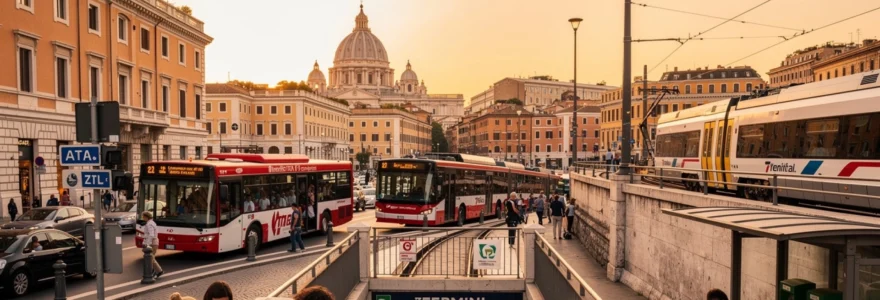
ATAC bus network peculiarities: route numbers, frequency gaps and ZTL complications
Once you step above ground, Rome’s bus network—operated mainly by ATAC—appears to fill many of the gaps left by the metro. In practice, though, visitors often find the bus system even more confusing. Routes overlap, timetables are approximate at best, and the city’s Zona a Traffico Limitato (ZTL, or Limited Traffic Zones) changes how and where buses can circulate, especially around the historic center. Understanding how to use Rome’s buses without losing time or patience can make the difference between a smooth day of sightseeing and an exhausting one.
One of the biggest surprises for first-time visitors is that the most “useful” bus lines on paper—those that connect major tourist attractions and transport hubs—also tend to be the most crowded and the most targeted by pickpockets. Meanwhile, lesser-known routes used by locals may be slower but far more comfortable and secure. Learning the personality of a few key lines before you arrive can help you choose wisely between express buses and quieter alternatives.
Express bus lines 40, 64 and H: pickpocketing hotspots versus local routes
If you ask any Roman which buses tourists should be cautious about, three numbers come up again and again: 40, 64, and H. These express bus lines connect major nodes like Termini, the Vatican, Trastevere, and central squares, making them magnets for visitors—and, unfortunately, for opportunistic thieves. Line 64, which runs between Termini and San Pietro, is infamous as a pickpocket hotspot, particularly during peak visiting hours for St. Peter’s Basilica and the Vatican Museums.
Line 40, a limited-stop express between Termini and Piazza Pia near the Vatican, often runs in articulated buses packed to the doors. In theory, it’s a convenient shortcut; in reality, it can feel like a moving sardine can, with travelers distracted by maps and phones. Line H, connecting Termini and Trastevere station, plays a similar role, shuttling visitors toward the nightlife district. In crowded conditions, even seasoned travelers can find it hard to notice nimble fingers around open bags and loose pockets.
Does that mean you should avoid these buses altogether? Not necessarily—but you should board them with the same vigilance you’d use in any major city. Keep bags zipped and in front of you, avoid back pockets for phones or wallets, and be wary of sudden jostling near doors. When possible, consider slower but less touristy alternatives, such as local routes that parallel part of Line 64 or walking a segment instead of riding one or two stops in crush conditions. Often, you’ll gain peace of mind while losing only a few extra minutes.
Navigating the limited traffic zone boundaries around piazza venezia and via del corso
One of Rome’s least intuitive quirks is the way its ZTL boundaries snake around the historic center. While ZTLs are designed to reduce congestion and pollution by restricting private vehicles, they also influence where buses can circulate and where taxis can legally drop you. Around key areas like Piazza Venezia, Via del Corso, and the streets leading to the Pantheon and Campo de’ Fiori, this can create what feels like an invisible barrier for newcomers trying to reach their hotel or a particular monument.
During core ZTL hours, many streets are closed to non-authorized vehicles but remain open to buses and some taxis. This means your bus may take a circuitous route, looping around Piazza Venezia or approaching Via del Corso from the river rather than cutting through directly. Timetables don’t always reflect these minor detours clearly, and on weekends or special event days (such as marathons or demonstrations), diversions can be announced only at the last minute in Italian.
For you as a visitor, the key is to focus on major bus stops just outside the densest ZTL areas and be prepared to walk the final stretch. For instance, buses often stop on the fringes of Piazza Venezia, from where it’s a short walk to the Capitoline Hill, the Jewish Ghetto, or Corso Vittorio Emanuele II. Rather than obsessing over getting a bus that drops you “right at” your destination, think of the ZTL as a pedestrian-first zone that you enter on foot after leaving your vehicle at the edge. This mindset shift will make Rome’s center feel less like a maze and more like a walkable open-air museum.
Night bus network N routes: coverage gaps between testaccio and vatican city
Rome’s metro shuts down relatively early by big-city standards, leaving night buses—marked with an N—as the primary public transport option after about midnight. On paper, the night bus network covers most major districts. In practice, there are noticeable gaps and awkward connections, particularly between nightlife hotspots such as Testaccio and the Vatican area. This can surprise visitors expecting a 24-hour metro culture similar to London or New York.
If you’re enjoying dinner or drinks in Testaccio and staying near the Vatican or Prati, you may find there is no simple direct night bus. Instead, you might have to ride one N-line toward the center, then transfer near Largo Argentina or Piazza Venezia, and catch another bus heading toward your accommodation. Waiting times at night can stretch to 20–30 minutes, and stops may feel poorly lit or confusing if you’re unfamiliar with the area.
How can you navigate this without stress? Before heading out for the evening, check the latest night bus routes and timetables using a journey planner, and note where you might need to change. In some cases, sharing a taxi or ride-hail from Testaccio or Trastevere back to Vatican City will be worth the extra cost, especially if you’re traveling in a small group. Consider your comfort level: Rome is generally lively late into the evening, but standing alone at an unfamiliar suburban stop for a night bus may not be the experience you want on your short break.
Real-time journey planner apps: roma mobilità versus moovit accuracy discrepancies
To make sense of Rome’s shifting network, most visitors turn to journey planner apps. The two most commonly used are the official Roma Mobilità tools and third-party apps like Moovit or Google Maps. While these apps are invaluable, you’ll quickly notice discrepancies between them—sometimes in departure times, sometimes in suggested routes, and occasionally in whether a particular bus is even shown as running. This can be frustrating when you’re standing at a stop wondering which source to trust.
Roma Mobilità’s data feeds are generally the most up to date on strikes, temporary diversions, and service suspensions. However, the interface can feel less intuitive if you’re used to sleek global apps. Moovit and Google often provide more user-friendly maps and walking directions, but they sometimes rely on scheduled data rather than true real-time updates, especially for less frequent suburban routes or night buses. The result? A bus shown as “due in 5 minutes” might actually be stuck in traffic across town—or have been cancelled without the app catching up.
A practical approach is to treat apps as guides rather than gospel. Use Roma Mobilità or the official website for big-picture information about strikes, maintenance works, and line changes, then cross-check your exact route on Moovit or Google for better walking instructions and stop names in English. When in doubt, look at the physical timetable at the stop and watch what locals are doing. If a crowd suddenly abandons a stop and walks to the next one, or checks the notice boards with concern, it may be a sign that a delay or diversion has just been announced.
Trenitalia regional trains as suburban metro alternatives: FL1, FL3 and FL5 lines
Beneath the surface of Rome’s official metro map lies another, often underused, rapid transit layer: Trenitalia’s regional FL lines. These commuter trains fan out from the city like spokes, connecting Fiumicino Airport, the Vatican area, Trastevere, and numerous suburbs. For visitors willing to think beyond the metro map, lines such as FL1, FL3, and FL5 can function as a kind of “shadow metro,” often faster and less crowded than buses or the subway.
The catch? These suburban rail services are not fully integrated into the mental map of most tourists. Station names may not immediately signal their proximity to famous sights, and signage inside the stations is geared more toward commuters than occasional visitors. Yet once you understand how the network is structured, you can bypass some of the metro’s biggest bottlenecks—especially around Termini—and reach districts like Trastevere or San Pietro with surprising ease.
FL1 leonardo express service: fiumicino airport connection versus standard regional fare structure
Most first-time visitors flying into Fiumicino Airport are funnelled toward the Leonardo Express, a dedicated non-stop train linking the airport and Termini in about 32 minutes. It’s fast, frequent, and heavily advertised—but also significantly more expensive than the alternative FL1 regional service. As of recent years, a Leonardo Express ticket costs roughly three times more than a standard regional ticket, which can surprise budget-conscious travelers.
The FL1 line, by contrast, runs from Fiumicino toward Tiburtina and beyond, stopping at key intermediate stations like Trastevere, Ostiense, and Tuscolana. For many visitors staying near Trastevere or south of the center, FL1 is not only cheaper but more convenient, avoiding an unnecessary connection at Termini. The trade-off is that FL1 does not go to Termini directly, and trains can be busier at commuting times, with fewer luggage racks than the Leonardo Express.
So which should you choose? If you’re staying near Termini and value a simple, straightforward journey with clear signage in English, Leonardo Express may be worth the premium. But if your accommodation is in Trastevere, around Piramide/Ostiense, or in the southern and eastern districts, the FL1 line can save you both money and time. Just remember that FL1 is a regular regional service: you’ll need to buy and validate a standard regional ticket, not a specific Leonardo Express fare.
Using FL3 and FL5 for san pietro, ostiense and trastevere access points
Two other suburban lines, FL3 and FL5, offer underappreciated shortcuts to some of Rome’s busiest tourist areas. FL3 connects central nodes like Ostiense and Trastevere with the northwestern suburbs, while FL5 links Termini’s eastern corridor with coastal destinations via key stops, including Roma San Pietro station. For visiting the Vatican, San Pietro station can be a smarter choice than wrestling with Line A during rush hour, as it’s a short walk from St. Peter’s Square.
If you’re staying near Trastevere, you can use the FL3 and FL5 lines to hop between Trastevere, Ostiense (close to Piramide metro and the Ostiense nightlife zone), and San Pietro without going anywhere near Termini. Think of these lines as a semi-circular bypass: instead of traveling into the center and back out again, you glide around the city’s western edge. Trains are usually less crowded than metro cars at peak tourist times, and the above-ground journey offers glimpses of neighborhoods most visitors never see.
To make the most of these lines, take a moment to study a combined metro and regional rail map, which many guidebooks and apps now include. You’ll notice that stations like Trastevere, Ostiense, and Valle Aurelia act as transfer points between Trenitalia regional trains and ATAC metro or bus services. Once you grasp these nodes, you can start to piece together journeys that feel more like a native commuter’s route than a tourist’s zigzag from landmark to landmark.
Ticket validation protocols: green machines versus on-board penalties
Whether you use FL1, FL3, FL5, or other regional trains, one rule remains non-negotiable: you must validate your paper ticket before boarding. Across Rome and the Lazio region, you’ll see small green (and sometimes yellow) machines on station platforms or near stairways. Insert your ticket to have it stamped with the date and time; from that moment, it’s valid for a limited period according to the fare rules. Skipping this simple step is one of the most common—and costly—mistakes first-time visitors make.
Unlike in some countries where inspectors rarely appear, Italian ticket checks on regional trains can be frequent and strict. If you’re found with an unvalidated ticket, even if you purchased it in good faith, inspectors are authorized to issue on-the-spot fines that far exceed the ticket price. Explaining that you didn’t understand the system usually won’t help; the policy is clearly signposted in Italian and English at most major stations, and inspectors hear the same excuses daily.
To avoid penalties, build a quick validation check into your routine: buy the ticket, locate the validation machine before you head to the platform, and double-check the printed stamp. If the machine is out of order, take a photo and seek out another machine on a different platform. In smaller stations where machines genuinely aren’t functioning, you can approach the conductor upon boarding and ask them to validate your ticket manually—but it’s much safer not to rely on this exception.
Tram system anomalies: historic tram 3 route and modern 5, 14, 19 line operations
Rome’s tram network looks modest compared to cities like Lisbon or Vienna, yet it plays a crucial role in linking neighborhoods the metro doesn’t reach. For visitors, trams offer a scenic, above-ground alternative to crowded buses and confusing one-way streets. At the same time, the system has its own quirks: partially overlapping lines, inconsistent stop names, and rolling stock that can range from vintage rattlers to sleek modern vehicles—all on the same route.
Tram 3 is perhaps the most interesting line for tourists, acting as a historic ring that skirts the edge of the ancient center. It passes relatively close to the Colosseum, San Giovanni, and the Villa Borghese area, providing a useful cross-town link that doesn’t depend on Termini. Yet many visitors overlook it because it doesn’t appear as prominently on simplified tourist maps. Think of Tram 3 as a semi-circle hugging the historic core, letting you glide past ancient walls and leafy boulevards while skipping some of the metro’s crowds.
Modern lines 5, 14, and 19 serve the eastern and northern suburbs and are less directly useful for classic sightseeing, but they can be invaluable if your accommodation lies along their routes. Line 19, for example, connects the Vatican area (near Piazza Risorgimento) with places like Piazza Bologna, passing near the MAXXI museum and the northern districts. Service frequency can be irregular outside peak hours, and delays due to traffic or parked cars on tracks are not uncommon, which can surprise visitors expecting tram-only lanes like in Northern Europe.
If you decide to use trams as part of your Rome transportation strategy, treat them as hybrid creatures: faster and more predictable than buses in many cases, but still subject to surface-level disruptions. Check stop names carefully, as they sometimes differ slightly between printed maps and onboard displays, and be prepared to walk a block or two if the tram stops are set back from the main tourist sights. As with buses and the metro, your standard BIT or time-based passes cover tram rides, making them a low-risk way to experiment with alternative routes.
Contactless payment rollout and BIT, ROMA 24H, ROMA 48H ticket confusion
Another aspect of Rome’s public transport that often surprises first-time visitors is the mix of old and new ticketing systems. On the one hand, you’ll find paper tickets, punch-validation machines, and kiosks that feel straight out of the 1990s. On the other hand, recent years have seen a gradual rollout of contactless payment at metro turnstiles and on some buses, allowing you to tap a bank card instead of buying a separate ticket. This coexistence of systems can create confusion about what you actually need—and what offers the best value.
The basic single-ride ticket, known as the BIT, is valid for 100 minutes from first validation on buses and trams and for a single metro journey. For many visitors, though, time-based passes such as ROMA 24H, ROMA 48H, and longer options can make more sense. These passes allow unlimited travel on metro, buses, and trams within their validity period, which is ideal if you plan to crisscross the city several times a day. The difficulty lies in choosing the right combination when you first land, especially if you’re not yet sure how often you’ll use public transport versus walking.
Contactless payment adds another layer: at many metro stations, you can now tap in with a compatible credit or debit card, with the system capping your daily charges automatically, similar to London’s Oyster/contactless model. However, this tap-and-go option doesn’t always integrate seamlessly across all buses and trams, and it may not be recognized by Trenitalia regional services. In addition, some international cards may encounter occasional processing hiccups, leaving tourists worried about whether their tap was registered correctly.
To keep things simple, consider this approach: if you plan a very transport-heavy day—visiting the Vatican, Colosseum, and outlying districts—buy a ROMA 24H or 48H pass and use it freely without worrying about each ride. On days when you expect to walk more and only take one or two metro or bus trips, use either BIT tickets or contactless payment on the metro if your card works reliably. Always keep at least one paper ticket or active pass as a backup in case a tap reader fails or your card is declined.
Pedestrian-only zones and cobblestone street navigation around campo de’ fiori and pantheon
Finally, one of Rome’s greatest charms—its pedestrian-friendly historic center—is also one of its most surprising transportation quirks. Around Campo de’ Fiori, the Pantheon, Piazza Navona, and nearby lanes, you’ll find extensive pedestrian-only areas where buses can’t enter and taxis have limited access. For visitors used to being dropped at the doorstep of every attraction, this can feel inconvenient at first. Yet these zones are precisely what make central Rome feel like a living museum rather than a traffic-clogged maze.
Within these pedestrian areas, your main “mode of transport” becomes your own two feet, often over uneven cobblestones that date back centuries. Suitcases with small plastic wheels, high heels, and flimsy sandals all struggle on this terrain. Add in crowds, outdoor dining terraces, and delivery scooters threading through narrow gaps, and you begin to see why moving even a few hundred meters can take longer than you’d expect. Planning footwear and luggage with Rome’s cobblestones in mind is not just a comfort issue—it’s a practical transportation decision.
How do you navigate these pedestrian-only zones effectively? First, identify a few key entry points where taxis and buses can legally drop you: Corso Vittorio Emanuele II for Campo de’ Fiori, Largo Argentina and Piazza Venezia for the Pantheon and Piazza Navona, and the Tiber embankments for the Jewish Ghetto. From these edges, think of your route as a gentle walking loop rather than a series of point-to-point transfers. In many cases, you can visit several major sights—such as the Pantheon, Piazza Navona, and Campo de’ Fiori—within a compact, car-free radius.
It helps to adjust your expectations: Rome’s center is not designed for “door-to-door” motorized transport in the modern sense. Instead, you move like a flâneur, weaving through piazzas, side streets, and fountains at a more human pace. Once you embrace this slower rhythm, the lack of direct bus or metro access to every square becomes less a frustration and more an invitation. After all, in a city where every corner might hide a Baroque church or a gelato shop, the walk between stops is half the experience.


